Pacific Ocean

|
Perusing the
Pacific The
real reason I wanted to explore Tuitui was to sit on the beach on the seaward
side of the motu and watch the Pacific Ocean crashing over
the coral.
From
our warm and sheltered spot we could both enjoy the rugged
side of this lady from the safety of dry land. Usually we don’t want to
see her like this and try to keep well away from her temper when sailing.
Sunset over the Pacific Ocean seen from the International Space
Station. (Anvil tops of thunderclouds
are also visible).
The
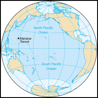
Pacific Ocean is the largest of
the Earth's
oceanic
divisions. It extends from the Arctic in
the north to Antarctica in
the south, bounded by Asia
and Australia in
the west, and the Americas in
the east. At 63.8 million square miles the Pacific covers about 46% of the
Earth's water surface and about one-third of its total surface area, making it
larger than all of the Earth's land area combined at 58 million square miles.
The equator
subdivides it into the North Pacific
Ocean and South Pacific
Ocean, with two exceptions: the Galápagos
and Gilbert
Islands, while straddling the equator, are
deemed wholly within the South Pacific.
 The Mariana
Trench in the western North Pacific is the
deepest point in the world, reaching 35,797 feet.
History: The
east side of the ocean was discovered by Spanish explorer Vasco Núñez de
Balboa in
the early 16th century. Balboa's expedition crossed the Isthmus of
Panama
and reached the Pacific Ocean in 1513. He named it Mar del Sur (South
Sea). Later, Portuguese explorer Ferdinand
Magellan
sailed the Pacific on a Spanish expedition of world circumnavigation
from 1519 to 1522. Magellan called the ocean Pacífico or "Pacific"
because, after sailing through the stormy seas off Cape
Horn,
he was surprised how calm the waters became. Although Magellan himself died in
the Philippines in
1521, Spanish navigator Juan Sebastián
Elcano
led the expedition back to Spain across the Indian
Ocean
and round the Cape of Good
Hope,
completing the first world circumnavigation in 1522.
Island nations and territories of the Pacific.
The islands entirely within the Pacific Ocean can be divided into three main groups known as Micronesia, Melanesia and Polynesia. Micronesia, which lies north of the equator and west of the International Date Line, includes the Mariana Islands in the northwest, the Caroline Islands in the centre, the Marshall Islands to the west and the islands of Kiribati in the southwest. Melanesia, to the southwest, includes New Guinea, the world's second largest island after Greenland and by far the largest of the Pacific islands. The other main Melanesian groups from north to south are the Bismarck Archipelago, the Solomon Islands, Santa Cruz, Vanuatu, Fiji and New Caledonia. The largest area, Polynesia, stretching from Hawaii in the north to New Zealand in the south, also encompasses Tuvalu, Tokelau, Samoa, Tonga and the Kermadec Islands to the west, the Cook Islands, Society Islands and Austral Islands in the centre (our current base), and the Marquesas Islands, Tuamotus, Gambier Islands and Easter Island to the east.
Not always so peaceful.....
Climate: The weather systems in the Northern and Southern hemispheres generally mirror each other. The trade winds in the southern and eastern Pacific are remarkably steady while conditions in the North Pacific are far more varied with, for example, cold winter temperatures on the east coast of Russia contrasting with the milder weather off British Columbia during the winter months. Cyclones are liable to form south of Mexico, striking Central America between June and October, as well as in southeast and east Asia from May to December, especially in August and September. In the western Pacific, monsoons in the summer months contrast with dry winds in the winter which blow over the ocean from the Asian landmass. In the equatorial Pacific, El Niño, a band of warm ocean temperatures, affects weather conditions in the western Pacific. In the far north, icing from October to May can present a hazard for shipping while persistent fog occurs from June to December. Surface water temperatures in the Pacific can vary from −1.4 °C (29.5 °F), the freezing point of sea water, in the poleward areas to about 30 °C (86 °F) near the equator.
This heron was having no luck fishing in the shallows.
We watched the daredevil chap tempt fate in the waves, take off just in time and land time and time again.
Success thankfully for our nerves a fish, now full he flew off. Phew.
ALL IN ALL MUCH MORE OF THIS LADY TO EXPLORE HOPEFULLY WHEN SHE’S IN A PEACEFUL MOOD
.
|