Long Island
|
Long Island, The
Bahamas
 We picked up the hire car at eight thirty and off we set from Clarence Town to drive to the top of the island. Long Island is an island in the Bahamas that is split by the Tropic of Cancer. Its capital is Clarence Town. Long Island is one of the Districts of the Bahamas and is known as the most scenic island in the Bahamas. The population is roughly 4,000 inhabitants.
 
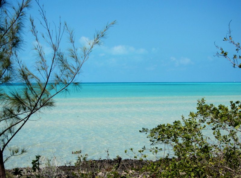
We stopped at the supermarket, freshly supplied by the once a week supply ship. A road kill victim Geography: Long Island is about eighty miles long and four miles wide at its widest point. The land area is 448 km². Long Island is situated about 265 km southeast of the Bahamian capital of Nassau, which is located on the island of New Providence. The Tropic of Cancer runs through the northern quarter of the island. The northeast side of Long Island is noted for its steep rocky headlands, while the southwest coast is noted for its broad white beaches with soft sand. The terrain ranges widely throughout the island, including white flat expanses from which salt is extracted, swamplands, beaches, and sloping (in the north) and low (in the south) hills. Long Island is particularly noted for its caves, which have played a major role in the island's history. Dean's Blue Hole is located west of Clarence Town - own blog - is the world's deepest underwater sinkhole. Long Island is surrounded by smaller bays and inlets, including the large New Found Harbor west of Deadman's Cay, at approximately the midsection of the island. There are also smaller islands off shore, including Sandy Cay.
 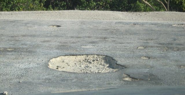  The road has several pot
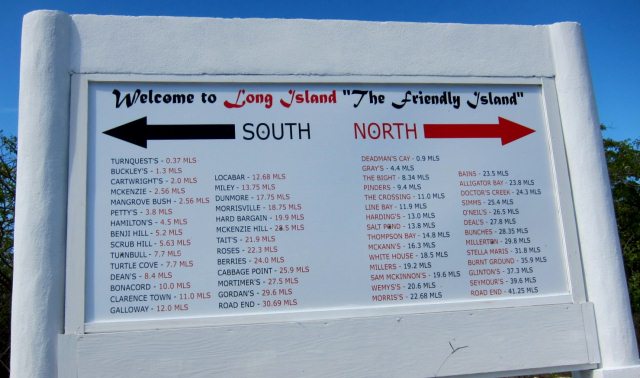
holes - not for the faint-hearted or those with a weak spleen. The road sign half way. The road in the
first of this set clearly showed us, when we went to explore it, that a small
exclusive estate had begun and was deserted, like so many of the islands we have
visited, when the money dries up or the backers go under. All along the road
were hundreds of boards advertising "acre with a view" and "Real Estate
Opportunities call now".
   Berger Paints live on. I
took these in the shade as in full sun, were quite painful
History: The island originally was called by the Arawak name "Yuma." It was rechristened "Fernandina" by Christopher Columbus on his first voyage in 1492, during which Long Island is believed to have been his third stop, following San Salvador and Rum Cay to the east. Archaeological evidence, including ceremonial stools called duhos, shows that the Lucayan Taíno tribe settled on Long Island, likely in the island's cave system. After the demise of the Lucayans, who were carried as slaves to Hispaniola and Cuba, there was no large settlement until the arrival of the Loyalists. The original Loyalists were mainly from New England and New Jersey and arrived on Long Island after fleeing the American Revolution. These families started the first farms, primarily raising cattle and sheep. By the 1790's, settlers began to arrive from the Carolinas and proceeded to set up cotton plantations. The plantations flourished for only a few years and, by the time of the abolition of slavery in 1834, most had collapsed and been abandoned. There are many ruins from this era today, the majority of which are overgrown by bush. There are also remains of some of the houses built after slavery, which are usually small and built of stone. Originally, they had thatched roofs; today, most are shingled. The descendants of these families continue to be widespread on the island.
    Settlements: Clarence Town, located in the south-central portion of the island, has a population of approximately three hundred and fifty. Nearby Deadman's Cay is the major settlement at the center of the island and is home to Deadman's Cay Airport, which offers several flights each week to Nassau and is the island's largest and busiest airport. We loved the tiny wholesaler, the name helped of course and loved Doctor's Creek.
  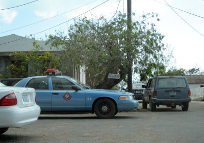  
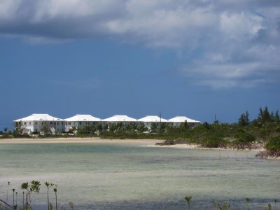
Bear really slowed down for the 'dangerous curve', clearly they haven't driven in Devon. The Police Station and jail complex and one of the schools, all in smart uniform. Mangrove Beach is the home of the island's boat-building trade, while Hamilton's is noted for its extensive cave system. Salt Pond is home of the Long Island Regatta, an annual event that draws tourists from around the world. Stella Maris, at the northern part of the island, is the center of the island's tourism industry and features several resorts. Buckley's is home to Nelson Granville MacFarlane Major High School, which frequently has the highest Bahamian GCSE scores among the nation's public schools, as well as the Long Island Library and Museum, sadly closed for the day. Other settlements include Buckley's, Hamilton's, Scrub Hill, Simms and Burnt Ground. Most of the island's settlements are named after the families that first settled in them. As a result, many (but not all) are named in the possessive form: The settlement of the Gray family, for example, is known as Gray's. One main road, originally designed for carriages, runs from Cape Santa Maria, at the northern tip of Long Island, to the southern tip at Gordon's. Transport on Long Island is generally road-based, with limited taxi service available, particularly from Stella Maris to Deadman's Cay and Clarence Town.
  One that amused Bear was this sign on the side of the road, opposite, said residence. He's in because his car is there. Don't know what he wants a hangar for, but, I reckon it's big enough for vasectomies on a Friday afternoon.
 
A roadside boutique, complete with discreet satellite dish Economy & Tourism: Part of the economy is based on tourism and farming, but fishing dominates. The inhabitants grow peas, corn, bananas, and pineapples, and they raise small livestock such as pigs, chickens, goats and sheep. Some cattle are raised for export. First island we have been to and not seen animals wandering around, no chickens, one cat and two dogs was the tally for the day. Due to the generally inhospitable soil of the Bahamas, much of the farming done on Long Island is in the pot-hole style, which involves planting in fertile holes in the limestone where good top soil collects. This method of farming contributes to the success of Long Island farmers, who are usually able to generate enough excess produce to sell their fruits and vegetables throughout the Bahamas. The churches had to have their own blog, there must be one per ten people and the 'One Careful Owner', well, I was in heaven and certainly spoilt for choice.
Tourist activities include sailing, fishing - a days deep sea fishing at $950, half day reff fishing $550 and a half day bonefishing $275 - I'll stick with our troll lines. Scuba diving, freediving, snorkeling and relaxing on beaches. Cape Santa Maria Beach, located at Stella Maris, is frequently ranked as one of the most beautiful beaches in the world. In recent years, competitive freedivers have sought out Dean's Blue Hole as a unique dive site, hosting both world records (most notably by New Zealander William Trubridge) and one world championship (in 2009). Most tourists charter an airplane or take a commercial flight from Exuma International Airport at George Town, Exuma or Nassau. International flights offered by Locair are planned and will mark the first return of regular international flights in over ten years.

ALL IN ALL A DELIGHT BUT I COULDN'T LIVE HERE A MIXTURE OF MODERN IN A QUAINT SETTING |


