Colca Canyon
|
Colca Canyon
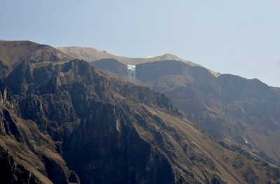
The Colca Canyon is a canyon of the Colca River in southern Peru. It is located about a hundred miles northwest of Arequipa. It is more than twice as deep as the Grand Canyon in the US at some thirteen thousand, four hundred and seventy one feet above sea level (quick - suck the Coca sweets). However, the canyon's walls are not as vertical as those of the Grand Canyon, but they are major features of the landscape. The Colca Valley is a colourful Andean valley with towns founded in Spanish Colonial times and formerly inhabited by the Collaguas and the Cabanas. The local people still maintain ancestral traditions and continue to cultivate the pre-Inca stepped terraces.

Geography: The Colca River starts high in the Andes at Condorama Crucero Alto and changes its name to Majes, and then to Camana before reaching the Pacific Ocean. Parts of the canyon are habitable, and Inca and pre-Inca terraces are still cultivated along the less precipitous canyon walls. The small town of Chivay is on the upper Colca River, where the canyon is not so deep but where many terraces are present in the canyon and continue for many kilometers downstream. As the canyon deepens downriver, a series of small villages are spread out over approximately thirty five miles between Chivay and the village of Cabanaconde. The canyon reaches its greatest depth and, in contrast, about fifteen miles to the southeast rises the twenty thousand, six hundred and thirty foot Nevado Ampato, a snow-capped extinct volcano. The valley lies in the Callalli and Huambo districts of the Caylloma Province.

These are the houses seen in the photograph above (high centre).   Attractions: The canyon is home to the Andean Condor (Vultur gryphus – own blog - and such a WOW), a species that has seen worldwide effort to preserve it. The condors can be seen at fairly close range as they fly through the canyon and are an increasingly popular attraction. 
'Cruz del Condor' is a popular tourist viewing stop, the pass where condors soar gracefully on the rising thermals occurring as the air warms. The condors are best seen in the early morning and late afternoon when they are hunting. At this point the canyon floor is three thousand, nine hundred and sixty feet below the rim of the canyon. The La Calera natural hot springs are located at Chivay, the biggest town in the Colca Canyon.
Name: The name Colca refers to small holes in the cliffs in the valley and canyon. These holes were used in Inca and pre-Inca times to store food, such as potatoes and other Andean crops. They were also used as tombs for important people.
  It seems so hard to believe hummingbirds can live up here -
but here is the Giant of them all
History: The Spanish laid out towns along the canyon and built churches there, but the towns did not thrive and have faded out of memory. In the 1980’s, the Majes Hydroelectric Project built roads and opened the area to outsiders. Access today is usually through Arequipa.
ALL IN ALL A DREAM COME TRUE TO BE HERE |