Lake Titicaca
|
Lake
Titicaca
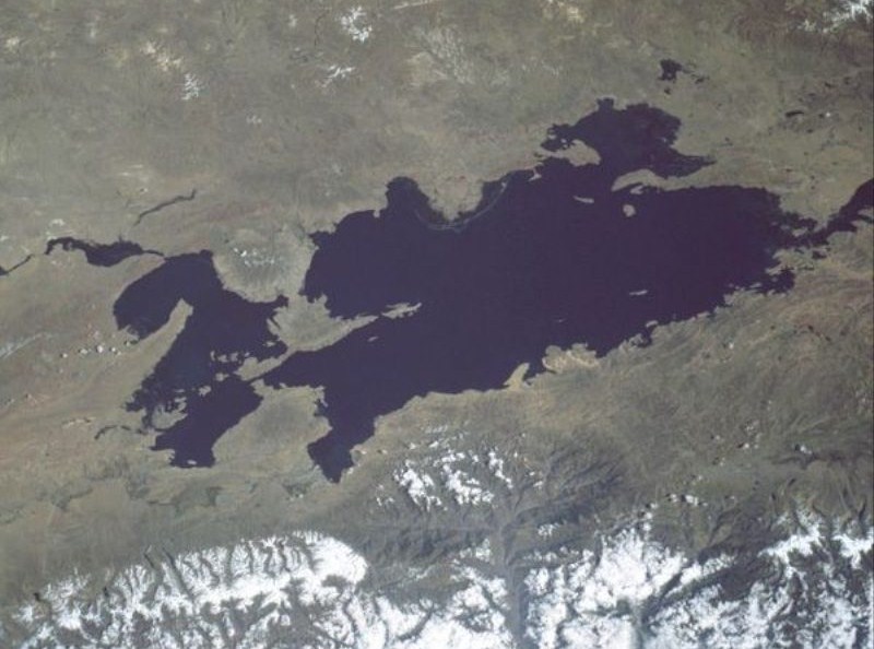
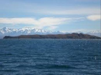
View from space, May 1985 (North is at right)
Our guide Manuel told us that the original name of the lake was Titi - Cala in Aymara literally means Puma Tongue. They believed the lake was in the shape of a puma about to pounce on a rabbit. Not meaning to get deep and meaningful but it does make you wonder how they worked that out. That brings into question how many other mysteries were known about, Easter Island, the Nazca Lines etc. etc.
Lake
Titicaca
is a lake located on the border of Peru and Bolivia. It sits twelve thousand
five hundred feet above sea level, making it one of the highest commercially
navigable lakes in the world. By volume of water, it is also the largest lake in
South America, five degrees, fifty minutes eleven South and sixty
degrees, twenty minutes nineteen West.
Overview: The lake is located at the northern end of the endorheic Altiplano basin high in the Andes. Sixty per cent - the western part of the lake lies within the Puno Region of Peru, and the eastern side is located in the Bolivian La Paz Department or forty percent.
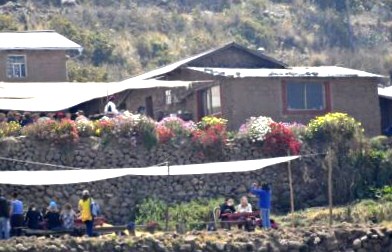
 Top of the map you can see Uros and Taquille Islands, the ones we visited.
We were up at five forty five to breakfast and be ready for pick up at quarter to seven. We were on the dock side at and off at seven thirty. Manuel told us there were sixty two known bird species on the lake, we had to get used to seeing Giant Coots and Seagulls. The lake is composed of two nearly separate sub-basins that are connected by the Strait of Tiquina which is two thousand six hundred and twenty feet across at the narrowest point. The larger sub-basin, Lago Grande (also called Lago Chucuito) has a mean depth of four hundred and forty three feet and a maximum depth of nine hundred and thirty two feet. The smaller sub-basin, Wiñaymarka (also called Lago Pequeño, "little lake") has a mean depth of thirty feet and a maximum depth of one hundred and thirty one feet. The overall average depth of the lake is three hundred and fifty one feet.
 
An excited Bear and the Freyans. Lake Titicaca is fed by rainfall and meltwater from glaciers on the sierras that abut the Altiplano. Five major river systems feed into the lake - in order of their relative flow volumes these are: Ramis, Coata, Ilave, Huancané, and Suchez. More than twenty other smaller streams empty into Titicaca and the lake has forty one islands, some of which are densely populated. Having only a single season of free circulation, the lake is monomictic, and water passes through Lago Huiñaimarca and flows out the single outlet at the Rio Desaguadero which then flows south through Bolivia to Lake Poopó. This only accounts for about 10% of the lake's water balance. Evapotranspiration, caused by strong winds and intense sunlight at altitude, balances the remaining 90% of the water input. It is nearly a closed lake.
 
Still odd to see navigation buoys. Anne and Alan proudly displaying their Troon Cruising Club Temperature:
The
cold sources and winds over the lake give it an average surface temperature of
ten to fourteen degrees Celsius. In the winter (June-September), mixing occurs
with the deeper waters, which are always between ten and eleven degrees.
Name:
The
origin of the name Titicaca is unknown. It has been translated as "Rock
Puma",
allegedly because of its resemblance to the shape of a puma hunting a
rabbit,
combining words from the local languages Quechua
and Aymara,
and as well as translated as "Crag of Lead." We liked the account from
Manuel. Locally, the lake goes by several names. Because the southeast
quarter of the lake is separate from the main body (connected only by the
Strait
of Tiquina),
the Bolivians call it Lago
Huiñaymarca (Quechua:
Wiñay Marka) and the larger
part Lago Chucuito. In Peru,
these smaller and larger parts are referred to as Lago Pequeño and Lago Grande, respectively. The signs
we saw said Lake Titikaka but most reference books say
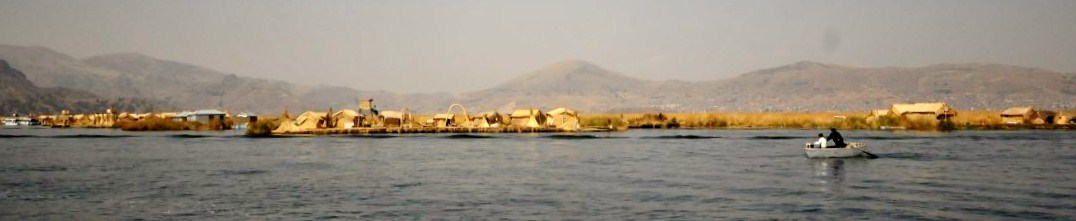
Titicaca. Islands Uros: Own Blog
As we got closer to Uros Island we could not have been prepared for what we saw
Amantaní:
is
another small island on Lake Titicaca populated by Quechua
speakers. About eight families live in six villages on the roughly circular six
square mile island. There are two mountain peaks, called Pachatata (Father
Earth) and Pachamama (Mother Earth), and ancient ruins on the top of both peaks.
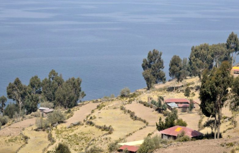
The hillsides that rise up from the lake are terraced and planted with
wheat,
potatoes
and vegetables. Most of the small fields are worked by hand. Long stone fences
divide the fields, and cattle, sheep, and alpacas
graze on the hillsides. There
are no cars on the island and no hotels. A few small stores sell basic goods,
and there is a health clinic and school. Electricity was produced by a generator
and provided limited to a couple of hours each day, but with the rising price of
the petroleum, they no longer use the generator. Most families use candles or
flashlights powered by batteries or hand-cranks. Small solar panels have
recently been installed on some homes. Some
of the families on Amantaní open their homes to tourists for overnight stays and
provide cooked meals, arranged through tour guides. The families who do so are
required to have a special room set aside for the tourists and must fit a code
by the tour companies that help them. Guests typically take food staples
(cooking oil, rice, sugar) as a gift or school supplies for the children on the
island. They hold nightly traditional dance shows for the tourists where they
offer to dress them up in their traditional clothes and participate. Taquile: Own Blog
Taquille Island as we approached and a view from the top as we walked across the island
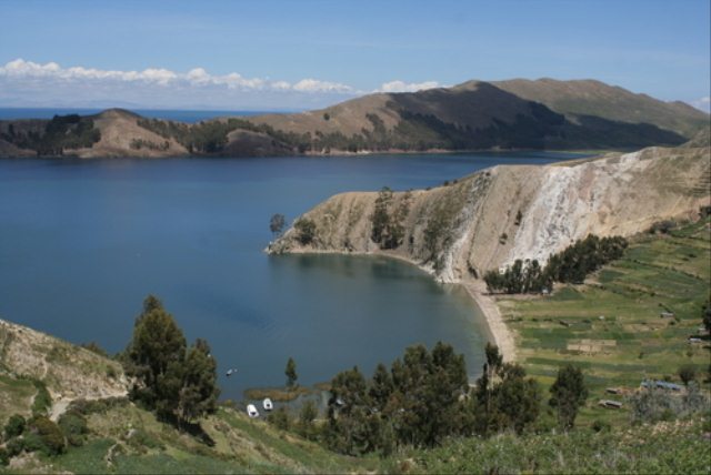
Isla del Sol: Situated on the Bolivian side of the lake with regular boat links to the Bolivian town of Copacabana, Isla del Sol ("Island of the sun") is one of the lake's largest islands. Geographically, the terrain is harsh; it is a rocky, hilly island. There are no motor vehicles or paved roads on the island. The main economic activity of the approximately eight hundred families on the island is farming, with fishing and tourism augmenting the subsistence economy. There are over one hundred and eighty ruins on the island. Most of these date to the Inca period circa the 15th century AD. Many hills on the island contain agricultural terraces, which adapt steep and rocky terrain to agriculture. Among the ruins on the island are the Sacred Rock, a labyrinth-like building called Chicana, Kasa Pata and Pilco Kaima. In the religion of the Incas, it was believed that the sun god was born here. During 1987-92 Johan Reinhard directed underwater archaeological investigations off of the Island of the Sun, recovering Inca and Tiahuanaco offerings. These artifacts are currently on display in the site museum of the village of Challapampa.
 Isla de la Luna: is situated east from the bigger Isla del Sol. According to legends that refer to Inca mythology Isla de la Luna (moon in Spanish) is where Viracocha commanded the rising of the moon. Ruins of a supposed Inca nunnery occupy the oriental shore.
 Suriqui:
lies
in the Bolivian part of lake Titicaca (in the southeastern part also known as
lake Huiñamarca). Suriqui is thought to be the last
place where the art of reed boat construction survives, at least as late as in
1998. Craftsmen from Suriqui helped Thor
Heyerdahl
in the construction of several of Transport:
A
ferry connects the 1435mm gauge railway of Peru
at Puno
with the 1000mm gauge railway of Bolivia
at Guaqui. Miscellaneous: The Bolivian Naval Force uses the lake to carry out naval exercises, maintaining an active navy despite being landlocked. The partly-salt Lake Maracaibo in Venezuela is the only body of water in South America larger than Titicaca, at about five thousand square miles. Lake Titicaca was designated a Ramsar site on the 26th of August 1998. Since 2000 Lake Titicaca has experienced constantly receding water levels. Between April and November 2009 alone the water level has sunk by eighty one centimeters and has now reached the the lowest level since 1949. This drop is caused by shortened raining seasons and the melting of glaciers feeding the tributaries of the lake.
ALL IN ALL A VERY EXCITED BEAR ONE OF MY ULTIMATE WOWS EVER |