Stacia
|
Saint Eustatius
Saint Eustatius, known affectionately to the locals as Statia or Statius is a special municipality (officially a "public body") of the Netherlands. It lies in the northern Leeward Islands portion of the West Indies, southeast of the Virgin Islands and immediately to the northwest of Saint Kitts and Nevis and to the southeast of Saba. The island is named after the legendary Christian martyr Saint Eustace. The regional capital is Oranjestad. Formerly part of the Netherlands Antilles, Saint Eustatius became a public body (often referred to as "special municipality") within the country of the Netherlands on the 10th of October 2010. The island has an area eight square miles. In 2004, the population was estimated at 2,498 inhabitants. During the 18th century the island had the sobriquet 'Rock of Gold' with a population of 8000 - the days of wealth. The official language is Dutch, however English is mostly spoken. A local English-based creole is also spoken informally. Travel to the island by air is through F.D. Roosevelt Airport.
  History: The island was seen by Christopher Columbus in 1493 and claimed by many different nations over the course of the next 150 years. In 1636, it was colonised by the chamber of Zeeland, and as of 1678, the islands of St. Eustatius, Sint Maarten and Saba fell under direct command of the Dutch West India Company, with a commander stationed on St. Eustatius to govern all three. At the time, the island was of some importance for sugar cultivation. In the 18th century, St. Estatius's geographical placement – at the fulcrum between the Leeward and Windward Islands of the Lesser Antilles, in the middle of Danish (Virgin Islands), English (Jamaica, St. Kitts, Barbados, Antigua), French (Ste. Lucie, Martinique, Guadeloupe) and Spanish (Cuba, Puerto Rico, Hispaniola) territories – its large harborage, neutrality and status from 1756 as a free port with no customs duties were all factors in it becoming a major point of transhipment of goods, and a locus for trade in contraband. The island was known as The Golden Rock and its economy flourished by ignoring the trade embargoes between the great powers. Edmund Burke said of the island in 1781 “It has no produce, no fortifications for its defense, nor martial spirit nor military regulations ... Its utility was its defense. The universality of its use, the neutrality of its nature was its security and its safeguard. Its proprietors had, in the spirit of commerce, made it an emporium for all the world. ... Its wealth was prodigious, arising from its industry and the nature of its commerce”.
  "First Salute": Since the island sold arms and ammunition to anyone willing to pay, it was one of the few places from which the rebellious Thirteen colonies could obtain weaponry. This good relationship between St. Eustatius and the United States resulted in the noted "First Salute" of the 16th November 1776, when Commander Johannes de Graaff of St. Eustatius decided to return the salute fire of the visiting American brig Andrew Doria by firing the cannons of Fort Oranje, the first international acknowledgment of the independence of the United States. The gesture provided the title for Barbara W. Tuchman's 1988 book The First Salute: A View of the American Revolution.
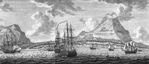 The British took the incident seriously, and protested against the continuous trade between the United States and St. Eustatius. In 1778, Lord Stormont claimed in Parliament that, "if Sint Eustatius had sunk into the sea three years before, the United Kingdom would already have dealt with George Washington". The trade between St. Eustatius and the United States was the main reason for the Fourth Anglo-Dutch War, which was disastrous for the Dutch economy. As a result of the war, St. Eustatius was taken (pillaged) by British Admiral George Brydges Rodney on the 3rd of February 1781. Commander De Graaff, who at the time did not know about the declaration of war, saw that he was facing superior forces and surrendered the island after firing two rounds as a show of resistance for the honor of Dutch Admiral Lodewijk van Bylandt, who commanded ships of the Dutch Navy which were in the harbour. Ten months later, the island was conquered by the French, allies of the Dutch in this war. The Dutch regained command over the island in 1784. This all marked the decline of the island, also it was eclipsed by other Dutch ports, such as those on the islands of Curacao and Sint Maarten, and the population gradually reduced in number.
 Jewish population: The island was home to a Jewish settlement, mainly merchants and
plantation owners. Within two days of the island being surrendered to the
British in February 1781, part of the Jewish community – all the men
– together with governor de Graaff, were forcibly deported, being given
only 24 hours notice. The Honen Dalim Synagogue, the
second oldest synagogue in the Western Hemisphere, built in 1739, and many of
the Jewish homes, were burned down by the British Admiral Rodney. The synagogue stood in ruins from 1781 until 2001, when its walls were
restored as part of the Historic
Core Restoration Project. Now funds are being sought from private
donors to construct a modern roof on the ancient ruins. There are no images
showing what the synagogue looked like when it was in use, therefore a proper
'restoration' of the structure to its former condition is not
possible. Dissolution of the Netherlands Antilles: Unlike the other member islands of the Netherlands Antilles, the people of St Eustatius did not vote to leave. In an 8th of April 2005, referendum, 77% of voters voted to remain within the Netherlands Antilles, compared to 21% who voted for closer ties with the Netherlands. However, once the other islands decided to leave, meaning that the Netherlands Antilles would become defunct, the island council opted to become a public body of the Netherlands like Saba and Bonaire.
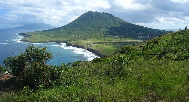 Geography: Geographically, the island is saddle-shaped, with the 602 meter-high dormant volcano Quill, (from Dutch kuil, meaning 'pit' - because of its crater) to the southeast and the smaller pair Signal Hill/Little Mountain (or Bergje) and Boven Mountain to the northwest. The Quill crater is a popular tourist attraction on the island. The bulk of the island's population lives in the "dip" between the two areas, which crosses the center of the island. The Great Hurricane of 1780 caused cataclysmic damage and the loss of over 4,000 lives on St. Eustatius. The national parks of St. Eustatius, comprising the Quill/Boven park, the Botanical Garden, and the Marine Park, are all under the control of the non profit foundation STENAPA.

ALL IN ALL NOT REALLY A HOLIDAY ISLAND |
