|
Hurricanes
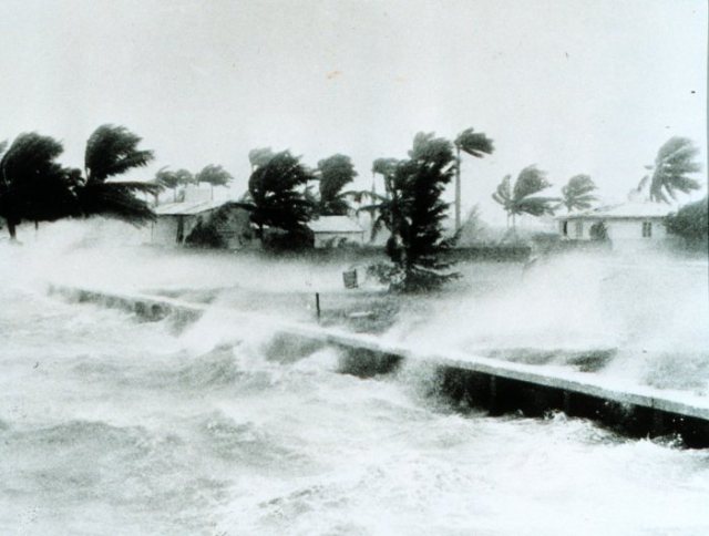
Hurricane photo from the
1800's
NOAA - The National Oceanic and
Atmospheric Administration, United States Department of Commerce - National
Weather Service is the primary source of weather data, forecasts and warnings
for the United States and its territories. The NOAA National Weather Service
operates the most advanced weather, flood warning and forecast system in the
world, helping to protect lives, property and enhance the national economy.
NOAA, is dedicated to enhancing economic security and national safety through
the prediction and research the of weather, in particular to predict hurricanes.
Through the emerging Global Earth Observation
System of Systems (GEOSS), NOAA is working with its federal partners and nearly
sixty countries to develop a global monitoring network that is as integrated as
the planet it observes.
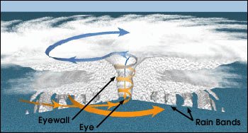
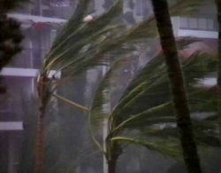
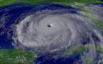
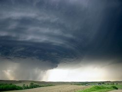
A view of a hurricane,
how they are formed and where they occur.
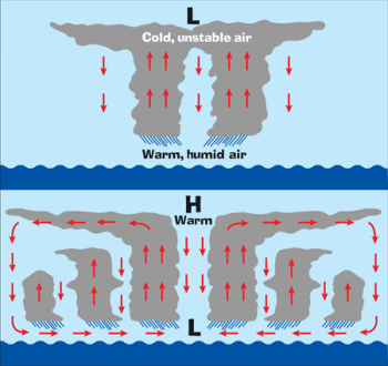
Hurricanes begin when areas of low
atmospheric pressure move off Africa and into the Atlantic, where they grow and
intensify in the moisture-laden air above the warm tropical ocean. Air moves
toward these atmospheric lows from all directions and curves to the right under
the influence of the Coriolis effect, thereby initiating rotation in the
converging windfields. When these hot, moist air masses meet, they rise up into
the atmosphere above the low pressure area, potentially establishing a
self-reinforcing feedback system that produces weather systems known to
meteorologists as tropical disturbances, tropical depressions, tropical storms,
and hurricanes.
Fortunately, fewer than 10 percent of disturbances grow into
hurricanes. Development of a fully fledged hurricane requires a rare combination
of atmospheric events. First, the tropical disturbance must produce converging
air masses. Second, the converging air must rise - but not in an area where
there are either strong winds or descending air masses aloft. Hurricane
development requires both an organized pattern of convection that is destroyed
by upper atmosphere winds, as well as unstable air masses in the upper
atmosphere that can carry rising surface air away from the upper end of the
developing storm.
If these three phenomena occur together, a self-sustaining
circulation develops in which moist surface air rises and its moisture
condenses, releasing latent heat that warms the upper atmosphere. The heated
atmosphere creates lift that extends the low pressure area upward and further
reduces its already low pressure. As winds in the upper atmosphere carry moist
air away from this growing cylinder of low pressure, dry warm air from above can
enter the centre of the cylinder, ultimately reaching the sea surface and
forming the cloud-free area known as the eye of the hurricane.
A system of
this type will continue to intensify as long as the upper-level outflow of air
exceeds low-level inflow. The relationship between inflow and outflow is
controlled by the heat content of the ocean water and the latent heat contained
in the moisture in the rising air. In other words, once formed, hurricane
circulation will continue as long as the storm is over warm water, has access to
moist air, and doesn’t drift into areas where upper-level winds can tear it
apart. The diameter of the eye can be 1.9 to 230 miles across, the average being
25-40 miles. Other names for a hurricane are cyclone, willi-willi and
typhoon. Hurricane season lasts from the 1st of June to the 30th of November.
The NOAA website is full
of fascinating data
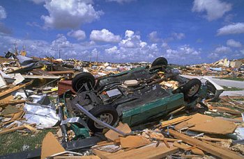
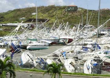
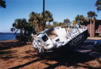
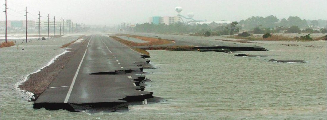
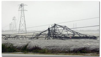
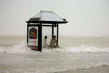
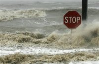
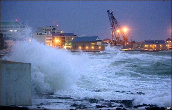
A fully formed hurricane carries three major
threats: low atmospheric pressure, high surface winds and heavy rainfall. These
threats are realized in different ways.
- Low central pressure becomes a threat when ocean
water bulges up under it and forms a storm surge when the hurricane comes
ashore.
- High surface winds can damage property directly,
but create an even more destructive force by creating high waves on the ocean
surface.
- Heavy rainfalls creating flooding increasing both
erosion and pollutant input as they run off the land.
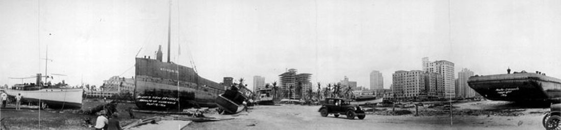
1926 "Miami"
Hurricane
Causes
Warm wet mass of air over the sea that
begin to evaporate
Water has to be 79 degrees or warmer
Combined actions
of air water, and heat produce a huge spinning system of clouds rain and wind
Effects
Rain causes floods
Thunderstorms are produced
Wind smashes
everything in its path
The most dangerous part of a hurricane is the storm
surge
Wind causes ocean waves to rise over the land, these waves can reach
30 feet in height
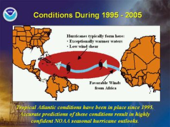
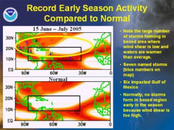
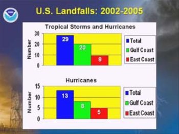
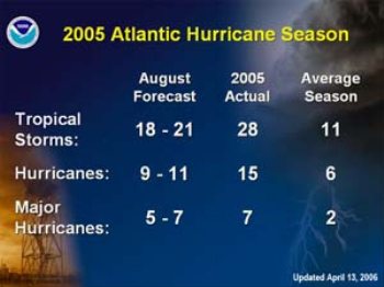
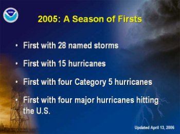
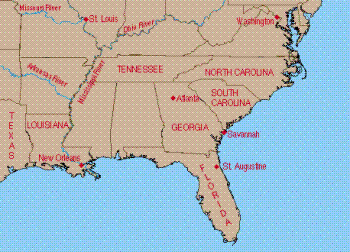
Predictions, 2005 a season of firsts. Map
showing the southern USA.
Top Ten Hurricane Disasters by cost
- 1926
"Miami"
$157 billion
- 1900
"Galveston" $99.4
billion
- 2005
Katrina
$81.0 billion this is before loss adjustment,
expected well over $160 billion.
- 1915
"Galveston" $68.0
billion
- 1992
Andrew
$55.8 billion
- 1938 "New England $39.2 billion
- 1944 "Pinar del Rio"
$38.7 billion
- 1928
"Okeechobee" $33.6 billion
- 1960
Donna $26.8 billion
- 1969
Camille
$21.2 billion
Top Ten Hurricane Disasters by loss of
life
- 1780 Great
Hurricane
27,500+
- 1998
Mitch
11,374-18,000
- 1900
"Galveston"
8,000-12,000
- 1974
Fiji
8,000-10,000
- 1930 "Dominican
Republic" 2,000-8,000
- 1963
Flora 7,186-8,000
- 1776
"Pointe-a-Pitre"
6,000+ This is where we were in
Guadeloupe
- 1775
"Newfoundland"
4,000-4,136+
- 1928
"Okeechobee" 4,075+
- 1899 "San
Ciriaco"
3,433+
Hurricane Hugo
Names.
It was clear a naming process had
to be agreed so meteorologists could identify a hurricane and also to sensitise
the general public. The practise began with the Spanish in the Americas, when
hurricanes were referred to by the name of the saint on whose feast day the
storm struck. Early in the 20th century when meteorologists began following the
paths of hurricanes, they identified them not by name, but by the lat and long
at which they were first sighted. That was not manageable for sending messages
to ships. Beginning in 1953, American meteorologists began identifying them by
the names in the phonetic alphabet then in use, Able, Baker, Charlie etc. But
that led to confusion when the International Phonetic Alphabet was adopted and
by then they decided to use women's names. That continued until 1979 when the
WMO under pressure from feminists decided to use men's names as well. 30 Names
are chosen from an alphabetical list of alternating male and female names The
National Weather Service started using men's names in 1979. There is now a
list of names on a six year cycle unless a name is retired. In the Far East that
thought of giving something so destructive a name is considered unseemly so they
have lists made up of animals, flowers, rivers etc.
2009 Atlantic Hurricane Names - Ana, Bill, Claudette,
Danny, Erika, Fred, Grace, Henri, Ida, Joaquin, Kate, Larry, Mindy, Nicholas,
Odette, Peter, Rose, Sam, Teresa, Victor and Wanda.
2010 Atlantic
Hurricane Names - Alex, Bonnie, Colin, Danielle, Earl, Fiona, Gaston,
Hermine, Igor, Julia, Karl, Lisa, Matthew, Nicole, Otto, Paula, Richard, Shary,
Tomas, Virginie and Walter.
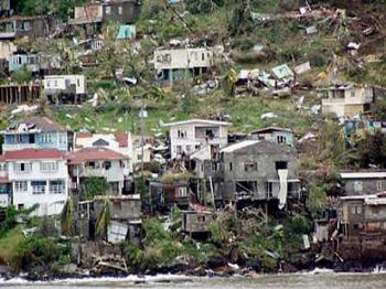
The Retirement of Hurricane Names
Hurricanes that have a severe impact on lives or the economy
are remembered generations after the devastation they caused, and some go into
weather history. The National Hurricane Centre near Miami, Florida, monitors tropical
disturbances in the Atlantic and eastern Pacific Oceans which could become a
hurricane. Whenever a hurricane has had a major impact, any country affected by
the storm can request that the name of the hurricane be "retired" by agreement
of the World Meteorological Organization (WMO). Retiring a name actually means
that it cannot be reused for at least 10 years, to facilitate historic
references, legal actions, insurance claim activities, etc. and avoid public
confusion with another storm of the same name. If that happens, a like gender
name is selected in English, Spanish or French for Atlantic Storms. There is an
exception to the retirement rule, however. Before 1979, when the first permanent
six-year storm name list began, some storm names were simply not used anymore.
For example, in 1966, "Fern" was substituted for "Frieda," and no reason was
cited.
Retired Names since 2000.
2007
Noel hit Puerto Rico, Cuba and the Bahamas. 2007
Felix hit Nicaragua and Honduras. 2007 Dean
hit Mexico and Jamaica. 2005 Wilma hit Cuba and Florida.
2005 Stan hit Mexico, Guatemala and El Salvador. 2005
Rita hit Louisiana, Texas and Florida. 2005
Katrina hit Louisiana, Mississippi, Alabama and Florida . 2005
Dennis hit Cuba and Florida. 2004 Jeanne hit
Florida and Haiti. 2004 Ivan hit Grenada, Cayman Islands, Cuba,
Alabama and Florida. 2004 Frances hit Florida. 2004
Charley hit Cuba and Florida. 2003 Juan hit
Nova Scotia. 2003 Isabel hit North Carolina, Virginia and
Maryland. 2003 Fabian hit Bermuda. 2002 Lili
hit Cuba and Louisiana. 2002 Isidore hit Cuba, Mexico and
Louisiana. 2001 Michelle hit Cuba and the Bahamas. 2001
Iris hit Belize. 2001 Allison hit Texas. 2000
Keith hit Belize and Mexico.
Measuring the Storm: The Saffir-Simpson Scale ranks
hurricanes by wind speed and damage potential. Herbert Saffir, an engineer in
Coral Gables, Florida, and Robert Simpson, then-director of the National
Hurricane Centre in Miami, created the scale about thirty-five years
ago.
They told National Geographic that they devised the scale to help relief
and public-safety agencies prepare for hurricanes and noted that it had been
known mostly only by officials but is now widely known by the general public
because of the increase in major storms.
Saffir told the magazine that he’s
“very pleased that the public is aware of the scale and can see the difference
between a Category One and a Category Five storm. That’s extremely important.”
Hurricane Wind Speeds. Barometric Pressure.
Storm Surge. Likely Damage.
Category 1
74 to 95 miles an hour. No lower than 980 millibars. 4 to 5
feet. Minimal. No significant damage to buildings. Damage will be mainly to
unanchored mobile homes, trees and shrubbery. There also will be some coastal
flooding and minor damage to piers.
Category 2 96 to
110 miles an hour. 965 to 979 millibars. 6 to 8 feet. Moderate. Damage
to some roofs, doors and windows. Considerable damage to trees, shrubbery and
mobile homes. Some flooding damage to piers and small craft. Some small craft
may break their moorings.
Category 3 111 to 130 miles
an hour. 945 to 964 millibars. 9 to 12 feet. Extensive. Some damage to
small residences and utility buildings. Mobile homes destroyed. Coastal flooding
destroys smaller structures, and larger structures damaged by floating debris.
Flooding may occur far inland.
Category 4 131 to 155
miles an hour. 920 to 944 millibars. 13 to 18 feet. Extreme. Heavy
damage to many residences, with roofs completely destroyed on small residences.
Major erosion of beaches. Flooding may occur far inland.
Category
5 Exceeding 155 miles an hour. 920 millibars. More than 18
feet. Catastrophic. Roofs completely destroyed on many residences and
larger buildings. Some buildings completely destroyed. Major flood damage to
lower floors of buildings near the shore. Massive evacuation may be required.
Flooding may occur far inland.
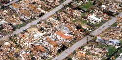
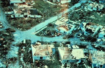
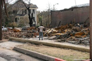
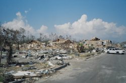
Damage caused by Hurricane
Andrew
Hurricane Andrew. The first named storm of 1992, is the
second most powerful, and the last of three Category 5 hurricanes that made U.S.
landfall during the 20th century, after the Labour Day Hurricane of 1935 and
Hurricane Camille in 1969. Andrew caused 65 deaths striking north-western
Bahamas, southern Florida (south of Miami), and southwest Louisiana around
Morgan City in August. Andrew caused $26.5 billion in damage, with most of that
damage cost in south Florida. Its central pressure ranks as fourth-lowest in
U.S. landfall records and Andrew was the costliest natural disaster in U.S.
history until surpassed by Hurricane Katrina of the 2005 season. It was also the
first of two Category 4 or higher storms to strike the United States that year
(Hurricane Iniki in the Central Pacific struck Hawaii a couple of weeks
later.
Aftermath of Hurricane Ivan
Hurricane Ivan was the strongest hurricane of the 2004
Atlantic Hurricane season. It was often dubbed in the media as Ivan the
terrible. The cyclone formed as a Cape Verde-type hurricane in early September
and became the ninth named storm, the sixth hurricane, and the fourth major
hurricane of the year. Ivan reached Category 5 strength on the Saffir-Simpson
Hurricane Scale, the strongest possible category. Ivan became the sixth most
intense Atlantic hurricane on record. At its peak in the Gulf of Mexico, Ivan
was the size of the state of Texas. It also spawned 117 tornadoes across the
eastern United States.
Hurricane Ivan Deaths/damage by country/Total
(USD) Barbados 1
death / $5 million. Cayman Islands 2 deaths / $1.85 billion. Cuba 0 deaths /
$1.2 billion. Dominican Republic 4 deaths / Unknown. Grenada 39 deaths
/ $1.1 billion. Jamaica 17 deaths / $360 million St. Lucia
0 deaths / $2.6 million. Saint Vincent and the Grenadines 0 deaths /
$40 million. Trinidad and Tobago 1 death / $4.9 million. United
States 54 deaths / $13 billion. Venezuela 3 deaths / unknown Totals:
121 / $16.442 billion.
Hurricane Rita
Hurricane Rita was the fourth-most intense Atlantic
hurricane ever recorded and the most intense tropical cyclone ever observed in
the Gulf of Mexico. Rita caused $11.3 billion in damage on the U.S. Gulf Coast
in September 2005. Rita was the seventeenth named storm, tenth hurricane, fifth
major hurricane, and third Category 5 hurricane of the historic 2005 Atlantic
hurricane season.
Rita made landfall on September 24 between Sabine Pass,
Texas and Johnsons Bayou, Louisiana, as a Category 3 hurricane on the
Saffir-Simpson Hurricane Scale. It continued on through parts of southeast
Texas. The storm surge caused extensive damage along the Louisiana and extreme
south-eastern Texas coasts and destroyed some coastal communities. The storm
killed seven people directly; many others died in evacuations and from indirect
effects.
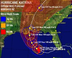
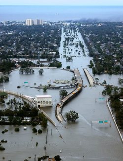
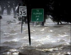
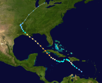
The path, the view, the flood waters and
damage of Hurricane Katrina.
Hurricane Katrina formed as Tropical
Depression Twelve over the south-eastern Bahamas on the 23rd of
August 2005 as the result of an interaction of a tropical wave and the remains
of Tropical Depression Ten. The system was upgraded to tropical storm
status on the morning of August 24 and at this point, the
storm was given the name Katrina. The tropical storm continued to move
towards Florida, and became a hurricane only two hours before it made
landfall between Hallandale
Beach and Aventura,
Florida on the morning of August 25.
The storm weakened over land, but it regained hurricane status about one hour
after entering the Gulf of Mexico. The storm rapidly
intensified after entering the Gulf,
growing from a Category 3 hurricane to a Category 5 hurricane in just nine
hours. This rapid growth was due to the storm's movement over the "unusually
warm" waters of the Loop Current, which increased wind speeds. On Saturday the
27th of August, the storm reached Category 3 intensity on the
Saffir-Simpson Hurricane Scale, becoming the third major hurricane of the season. An eyewall replacement
cycle disrupted the intensification,
but caused the storm to nearly double in size. Katrina again rapidly
intensified, attaining Category 5 status on the morning of the 28th
of August and reached its peak strength at 13:00 CDT that day, with maximum
sustained winds of 175 mph and a minimum central pressure of 902 mbar. The
pressure measurement made Katrina the fourth most intense Atlantic hurricane on
record at the time, only to be surpassed by Hurricanes
Rita and
Wilma later in the season; it was
also the strongest hurricane ever recorded in the Gulf of Mexico at the time (a
record also later broken by Rita). Katrina made its second landfall
at 06:10 CDT on Monday the 29th of August as a Category 3 hurricane
with sustained winds of 125 mph near Buras-Triumph,
Louisiana. At landfall, hurricane-force
winds extended outward 120 miles from the centre and the storm's central
pressure was 920 mbar. After moving over south-eastern Louisiana and Breton
Sound, it made its third landfall
near the Louisiana/Mississippi border with 120 mph sustained winds, still
at Category 3 intensity. Katrina maintained strength well into Mississippi,
finally losing hurricane strength more than 150 miles (240 km) inland near
Meridian, Mississippi. It was downgraded to a tropical depression near
Clarksville, Tennessee, but its remnants were last distinguishable in the
eastern Great Lakes region on the 31st August, when it was absorbed by a
frontal boundary. The resulting
extratropical storm moved rapidly to the
northeast and affected eastern Canada.
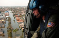 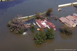 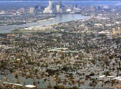 
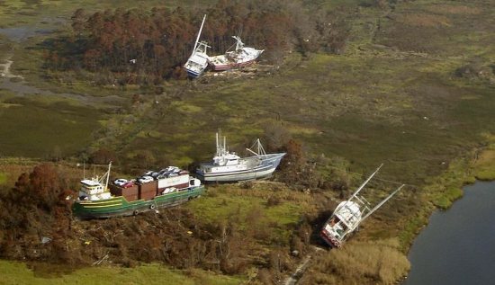
The effects of Hurricane Katrina in New Orleans were
shattering and long-lasting. Deaths by state Alabama 2, Florida 14, Georgia 2,
Kentucky 1, Louisiana 1,577*, Mississippi 238, Ohio 2, Total 1,836 Missing 705.
(*Includes out-of-state evacuees counted by Louisiana). When final figures are
known Katrina will be the most costly hurricane ever. Katrina redistributed over
a million people from the central Gulf Coast elsewhere in the US making it the
biggest dispora in the history of America. As the centre of Katrina passed east
of New Orleans on the 29th of August 2005, winds downtown were in the
Category 3 range with frequent intense gusts and tidal surge. Though the most
severe portion of Katrina missed the city, hitting nearby St.
Bernard and
Plaquemines parishes, the storm surge
caused more than 50 breaches in drainage canal levees and also in navigational
canal levees and precipitated the worst engineering disaster in the history of the United
States. By the 31st of August 2005,
eighty percent of New Orleans was flooded, with some parts under 15 feet of
water. Most of the city's levees designed and built by the US Army Corps of
Engineers broke somewhere, including the 17th Street
Canal levee, the Industrial Canal levee, and the London Avenue
Canal floodwall. These breaches were responsible for most of the flooding,
according to a June 2007 report by the American Society of Civil Engineers -
Oil refining stopped so the price of petrol increased all over the
world. Ninety percent of the residents of southeast
Louisiana were evacuated in the most successful evacuation of a
major urban area in the nation's history. Despite this, many remained (mainly
the elderly and poor). The Louisiana Superdome was used as a
designated "refuge of last resort" for those who remained in the city. The city
flooded due primarily to the failure of the federally built levee system. Many
who remained in their homes had to swim for their lives, wade through deep
water, or remain trapped in their attics or on their rooftops. The disaster had
major implications for a large segment of the population, economy and
politics of the entire US. It has prompted a Congressional
review of the Corps of Engineers and the near total failure of the federally
built flood protection system which experts agree should have protected the
city's inhabitants from Katrina's surge. Katrina has also stimulated significant
research in the academic community into urban planning, real estate finance, and
economic issues in the wake of a natural disaster. Because of the large loss of
life and property along the Gulf Coast, the name Katrina was officially retired on the 6th of
April 2006 by the WMO at the request of the U.S. government. It
was replaced by Katia on List III of the Atlantic hurricane naming
lists, which will next be used in the 2011 Atlantic hurricane
season.
Hurricane Gustav
Hurricane Gustav was the seventh tropical
cyclone , third
hurricane and second major hurricane of the 2008 Atlantic
hurricane season. Gustav caused serious damage
and casualties in Haiti, the Dominican Republic, Jamaica, the Cayman
Islands, Cuba and the United States. Gustav caused at least $8.5 billion (2008
USD) in damages. Gustav triggered the largest evacuation in United
States history. Over 3 million people fled the oncoming hurricane.
It formed on the morning of the 25th of August 2008, about 260
miles southeast of Port-au-Prince, Haiti, and rapidly
strengthened into a tropical storm that afternoon and into a hurricane early on
the 26th of August. Later that day it made landfall near the Haitian
town of Jacmel. It inundated Jamaica and ravaged Western Cuba and then
steadily moved across the Gulf of Mexico. Once into the Gulf, Gustav
gradually weakened due to increased wind shear and dry air. It weakened to a
Category 2 hurricane late on August 31, and remained at that intensity until
landfall on the morning of September the 1st near Cocodrie,
Louisiana. Weakening continued, and Gustav weakened to
a tropical storm that evening and to a tropical depression the next day as it
meandered around the south-central US. The weak system became extratropical on
the 4th of September and was absorbed by another low on September the 5th.
In total, an estimated 153 deaths had been attributed to Gustav in
the US and Caribbean. Damage in Louisiana totaled to $4.3 billion
(2008 USD) with additional damage of up to $4 billion in Cuba and
$210 million in damage in Jamaica. Deaths by country Haiti 77, Dominican Republic 8,
Jamaica 15, US 53, Total 153.
Operationally, Gustav went from a tropical depression to a
hurricane in 14 hours, tying Hurricane Humberto's record of 14 hours,
although this may be disputed in post-season analysis. Highest winds
recorded at 150 mph. Lowest pressure 941 mbar.
In the aftermath, the Canadian
government sent a C-17 airlifter, with a medical team,
from CFB Trenton to assist in the evacuation of New
Orleans, and two C-130 Hercules airlift planes from
Greenwood, Nova Scotia and from Winnipeg,
Manitoba. The UK sent HMS Iron
Duke and RFA Wave Ruler to provide emergency assistance and assess
the damage caused by Gustav. Anheuser-Busch is providing canned water to
affected residents. Russia announced it would send 4 cargo planes with
tents, construction materials, food, and essential supplies to
Cuba.
Whilst there have been no named hurricanes in June we WILL be
watching the barometer like hawks and listening to daily weather
reports.
ALL IN ALL a force to be taken very,
very seriously.
|