Date: 23-07-07 Time: 16:30:00 UTC Position: 53:53.75N 009:08.81E Name: Brunsbüttel
Vi hadde vinden med oss gjennom natta og klarte en brukbar fart. Vinden
rømte fra oss ved soloppgangen og vi gikk for motor i motstrøm. Timingen vår var
litt dårlig fordi vi kom inn til munningen av elven Elbe før tidevannet snudde -
slik at vi hadde tre knops motstrøm på det verste. Det ga seg etter tre timer og
vi avsluttet turen på stigende vann og strømmen med oss. Det var mange større
båter å se, men de holdte seg til leden for skipsfart lenger fra land. Spesielt
i dag tidlig var det mange seilbåter på vei ut fra Elbe-elven - Hamburg,
Cuxhaven, Brunsbüttel osv. De hadde strømmen med seg selvfølgelig og så ut til å
være på tur til Nederland eller Helgoland - to knøttsmå øyer som tilhører
Tyskland men er skattefrie områder. Hadde vi tenkt tanken kunne vi også stukket
innom for å fylle barskapet og dieseltankene. Ut i den sterk trafikkerte
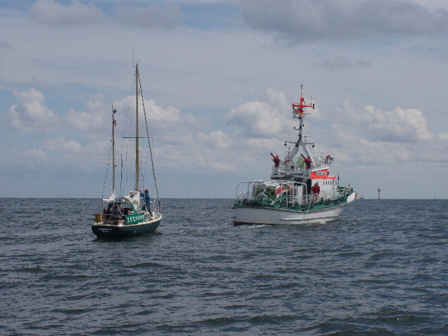
skipsleden inn til Hamburg hadde en seilbåt tydeligvis fått motorstopp - og drev
til havs med strømmen uten at seilene hjalp ham så mye. Han ble heldigvis
slept til havn av en redningsbåt. Se dagens bilde.
Skipsleden kan være fint å holde seg utenfor, og på et sted der elva bukter
seg veldig er det faktisk en snarvei mellom noen sandbanker. På kartet ser det
ut til å være vel merket og med en renne på minst 5m over en bredde på 400m. Det
ville spare ca. 10-15 minutter å ta snarveien. Etter en sjømil eller så ble jeg
oppmerksom på at vanndybden var atskillig mindre enn merket på kartet - vi var
ned i under 1m under kjølen, samt at staker manglet eller virket til å være i
andre posisjoner enn merket på kartet. En annen båt som fulgte etter oss var
tydeligvis også forvirret, og vi gikk forsiktig mot neste sjømerke. Her er det
tydelig at elveløpet har endret seg med noen sjømil siden mine kart ble til på
datamaskinen i 2003, og merkingen av dette alternativet blitt helt annerledes.
Vi kom fra opplevelsen uten problem - men det understreke at man skal enten
ha helt nye kart, eller følge etter båter i leden.
Flott med kystvakt når motoren
streiker og man driver inn i skipsleden.
Nice to have the coastguard nearby
when the motor stops and you are drifting into the shipping lanes.
English version
We had the wind with us through the night and managed a respectable speed.
The wind deserted us as the sun came up and we motored the remaining twelve
hours into Brunsbüttel. Out timing was poor as we came into the Elbe estuary -
we were too early for the ingoing tide and had three hours of up to three knots
against us before things became more pleasant and we could ride the tide up the
estuary. There were a lot of large ships around us all night and day - though
they kept to the shipping lanes further offshore and did not bother us. There
was an armada of sailboats leaving the Elbe this morning - catching the tide
out. These seemed to be mostly Germans and Dutch heading either for the Dutch
islands or the German tax-free islands of Helgoland. These islands were not
that much out of our way and I regret now not making a stop there to fill up the
wine cellar and diesel tanks. We saw an unfortunate sailboat in the shipping
lane who had clearly lost his motor - no wind either and a strong current
sweeping him further out to sea and the shipping lanes. Fortunately the
coastguard came out and towed him into harbour - see today's picture.
The main shipping route up the Elbe estuary is not a great place for a sail
boat, so we kept to the edges. At one point the estuary has a bid bend, but a
shallow and narrow channel is marked on the map as being a feasible route for
smaller vessels. 400m wide, 5m deep and marked every 1000m by a yellow stake
according to the map. I was a little suspicious when the first of the yellow
stakes was not where it should have been according to the map, and got more
worried when the 8m depth we should have been in was down to 3m. We slowed right
down, as did a Dutch boat that had been following us. Clearly both of us had the
same problem with out of date charts. We probed around carefully towards a north
cardinal mark, finding better water there. This mark did not agree with my map,
which by now said that we were aground. We followed a few other cardinal marks
which helped and we were soon out of the woods and back by the main channel. The
short-cut cost us at least half an hour extra! This was not a nice experience at
all, underlining the importance of having updated maps in places where the
topography changes - or at least keeping to the main marked leads.
|