Date: 10-03-07 Time: 23:00 UTC Position: 15:17.61N 061:23.19W Name: Roseau, Dominica
Det er forholdsvis mye vulkansk aktivitet her på Dominica, og stedet påstås
å ha verdens største kokende innsjø. Det var dette vi skulle gå til i dag. Først
må man kjøre 12 km i en taxi på bratte, smale og dårlige veier. Deretter er de
10 km til fots i regnskog på en vel vedlikeholdt sti som er bratt opp den ene
dalen, så bratt ned den neste. Stigningen fra veien til målet er ca. 600m, men
man går atskillig høyere på turen, og som sagt er det mye opp og ned. Vi brukte
tre time fram til denne kokende innsjø som er i et bratt krater som jeg tipper
er ca 80m i diameter. I midten veller det opp nær kokende vann ispedd bobler av
damp og svovelholdige gasser. Det hele er omgitt av en sky av damp som gjør
fotografering umulig. Når dampskyen blåses over observasjonspunktet stiger
lufttemperaturen og fuktighet slik at briller og linser dugger til momentant -
som å gå i et badstue. Vannet i innsjøen holder 92C. På veien dit (og tilbake)
passerer man "Desolation Valley", her bobler det opp damp og kokende vann mange
steder og temperaturen og svovelet gjør at det ikke vokser noen vegetasjon i
nærheten. Det er en slitsom tur og krever godt fottøy og en vis grad av kondis.
Vi var nokså slitne da vi kom tilbake til utgangspunktet - heldigvis hadde en
dame satt opp en enkel servering av kaldt drikke her. Her også går en elv
gjennom en trang kløft, 50m lang, mellom 1 og 3 m bred, og opp til 12m høy.
Vannet er dypt og vi svømte gjennom dette kløftet - utrolig forfriskende etter
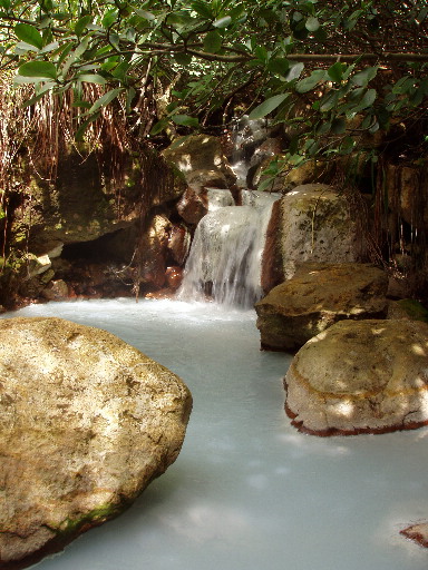
den harde fjellturen, men Rønnaug fikk kramper i begge beina! Dagens bilde - en
bekk som renner hvitt som melk av de vulkanske stoffene.
English version
Dominica has a lot of volcanic activity and can boast the world's largest
boiling lake. This was our goal for today. First there is an eight mile taxi
ride, an experience in itself on steep, narrow, and poorly maintained roads.
>From the end of the road the path is easy to follow for the six miles to the
lake, but is is very steep and rugged through the rain forest. It is not just up
either, but up and down again several times. The altitude gain is about 600m,
but more taking into account the undulations. It took us three hours to get to
the lake which is in a steep crater of about 80m i diameter I would guess. The
middle is a maelstrom of up-welling hot water and gases and the whole lake emits
a thick hot and smelly fog which makes photography impossible. When the fog gets
blown over the observation point glasses and camera lenses steam up instantly
and it is like walking into a steam bath. The water in the lake holds a
temperature of 92C. On the way to and from the lake one passes through
"Desolation Valley" where there are many places where steam, boiling water and
sulphurous gases flow through the earth's crust. Here there is no vegetation
because of the temperature and sulphur. The trip took us six hours in all, it is
pretty tough and needs good walking boots and a reasonable degree of fitness.
Back at where we started there is a narrow deep gorge with a clear river flowing
slowly through from a waterfall at the upper end to a small lake at the other.
Here one can bath in the cooling waters and swim the entire length of the gorge,
which is about 50m long, 1-4m wide and up to 12m high. The water is deep most of
the way - too deep to wade. This made a fantastic end to the trip and was
cooling on our tired legs. Rønnaug got cramp in her legs and had to spend some
time recovering before we walked the last few hundred metres down to the road.
Today's picture is of a stream which runs milky white from the volcanic
springs.
|