Day 4 - 50km past Ceduna to Mundrabilla Roadhouse
|
Sunday 5th February 2017 Distance driven 534 km (Total – 2208 km) White Well Corner – Nundroo Roadhouse - Head of the
Bight – Nullarbor Roadhouse - Bunda Cliffs – SA/WA Border Village
– Mundrabilla Roadhouse Not such an early start this morning as we had to wait until
07:20 for enough daylight – must be time to put the clocks back! We
cannot drive the van in the dark as the insurance only covers daylight
hours. A high proportion of accidents happen in the dark as the wildlife
become active and haven’t had their lesson from Tufty about road
safety. Still, we should be adjusting the time today as we expect to
cross the border into Western Australia this afternoon. We made a fuel stop at Nundroo Roadhouse – our policy
now is to top up as the opportunity arises and certainly not to let the tank
get below half-full (or empty, whichever way you want to look at it) –
and then stopped a little further along the road in the nicest rest stop we
have seen so far. It was huge, with lots of little alleyways among the
trees to park down, well away from the road. Back on the road we entered the Aboriginal lands around
Yalata, and it was interesting to see rest stops fly past with not a single
sign to tell us they were there. In fact, apart from a couple of local
signs, there was no signage along this whole stretch of road. The Yalata
Roadhouse, we read, had been closed down for refurbishment, and would be closed
for at least a year. As we drove past, it was interesting to see cars
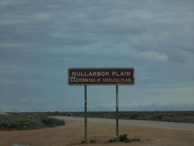
parked in front of many of the motel rooms. Around mid-morning we came across a sign marking the Eastern
end of the treeless zone – the Nullarbor Plain. Its name apparently
derives from the latin nullus arbor meaning ‘no
trees’. The area is a National Park and its dry plain is covered
with small, hardy bluebush and saltbush shrubs. They are drought
resistant and salt-tolerant. The shrubs thrive in arid conditions by
drawing moisture from the atmosphere through their leaves, and absorb the
equivalent of their weight each day.
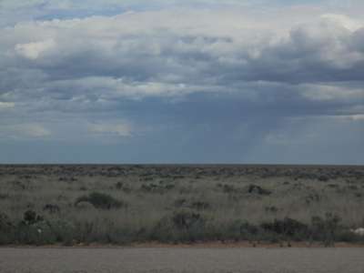
We had at last reached the beginning of the Nullarbor
Plain itself. And
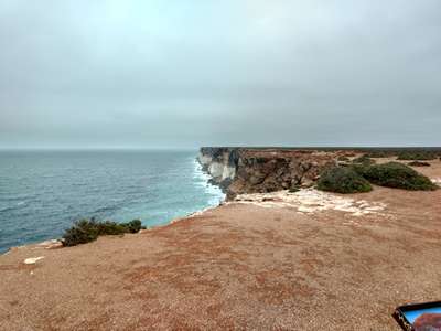
sure enough, there were no trees to be seen. But there was rain. Now the road started to run closer to the shoreline as it traced
along the top of the Bunda Cliffs. These cliffs rise 40m - 90m above the
Southern Ocean and stretch in an unbroken line 200km to the Western Australian
border. There are a number of viewpoints just off the main highway along
the way to the border, which we intended to visit today. Typically for
us, we were having unseasonably wet weather (yep, where have we heard that
before?!) and we were keeping our fingers crossed we would be able to see
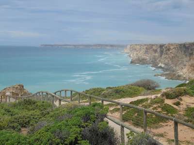
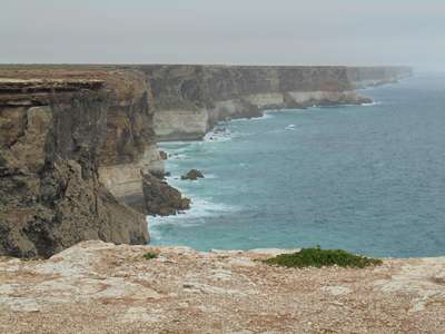
anything at all from the lookouts. Our first stop was at the Head of the Bight Lookout, which
we had all to ourselves as there are no whales to be seen at this time of the
year. Between June and October, however, it is a very popular viewing
point for Southern Right Whales which come right in to the coast to
breed. At any time of the year the view out into the Great Australian
Bight and along the Bunda Cliffs is awesome, and today was no exception,
despite the overcast weather. Breathtaking.
Looking out into the Great Australian Bight and west
towards the WA border from the Head of Bight Lookout. Fortunately the
rain had stopped and visibility was not too bad. 20,000 years ago, dry
land extended for a further 200km south of the Head of the Bight as the sea
level was 130 metres lower. Around 15,000 years ago, global warming led
to a rise in the sea level, and it has been at its current level for around
6,000 years. The cliffs are made of limestone and have three distinct
layers, which were more clearly seen when we stopped at the next lookout.
The three layers of limestone are clearly visible in the
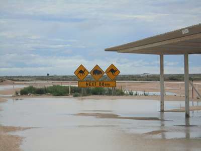
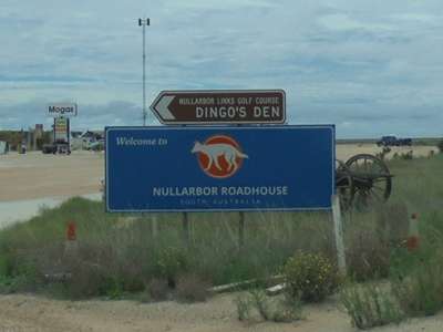
cliffs to the east, and to the west. We stopped for fuel at the Nullarbor Roadhouse, where the
evidence of the recent rainfall was all around. Here we saw a sign for
the Nullarbor Links Golf Course, which we had read about before leaving, and
then completely forgotten. You can sign up for a round of golf, get a
score card, and then hire the equipment and play a hole at a series of stops
across the Nullarbor Plain. A nice idea and we were sorry we had
forgotten to sign up.
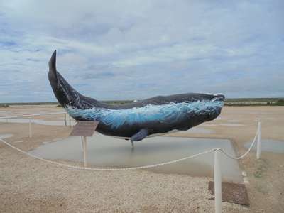
Not quite enough rain for this poor whale! Huge
puddles everywhere.
We noticed the sign for the Nullarbor Links Golf Course,
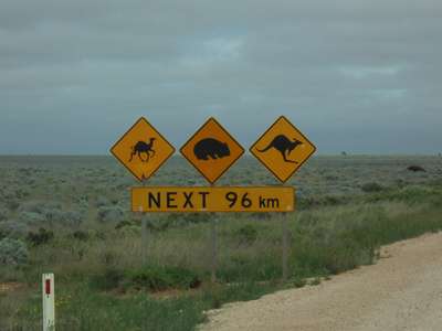
Dingo’s Den. On the road we needed to look
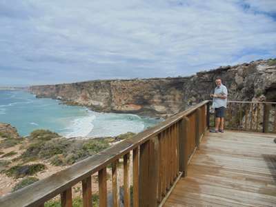
out for camels as well as wombats and kangaroos. We continued our drive along the Bunda cliffs, stopping at
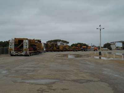
one or two more of the lookouts, and when we rejoined the highway after one
stop, there were two very wide loads coming along with two Police escort
cars. As we weren’t too keen to crawl along behind them, and there
was a big gap between the escort cars, Steve pulled out onto the highway
between them. A little further along, the lead escort car moved out of
our way to let us pass, and off we went. We thought that was the last we
had seen of them... Some time later we arrived at the SA/WA border, and pulled
into the Bordertown roadhouse just before the checkpoint to top up with
fuel. The wide loads must have passed us when we stopped at a lookout,
because they were now parked at the roadhouse. Steve filled up the tank
and I went inside to pay. When I came out, Steve was having a
conversation with a policeman. The same policeman who had been driving the
second escort car. And that policeman was not at all impressed with Steve
pulling out in front of him, even though we had not caused him to slow down at
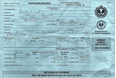
all. He clearly wanted to make his point though, and ended up giving
Steve a written warning. An authentic souvenir of our trip to SA!
The wide loads parked and waiting for WA police to escort
them across the border. Steve’s
warning. We drove the 100 metres to the checkpoint and pulled
up. A very nice young Border Patrol lady asked us if we had anything on
board we should declare. We told her what we had, and the first thing to
be confiscated was the unopened pot of honey we bought at Murphy’s
Haystacks. We are so stupid. We just didn’t think about the
border when we bought it. It seems we were not the first to be caught out
in precisely this way. She also took our potatoes which we hoped would be
okay as from Coles and washed, but apparently they have to be peeled and cooked
or frozen. Once we had the all-clear, we set off into Western
Australia, the last of the eight Australian states for us to visit. It is
an enormous state, around a third of the area of the whole country, and the
only state to stretch from the north to the south coast of the main island.
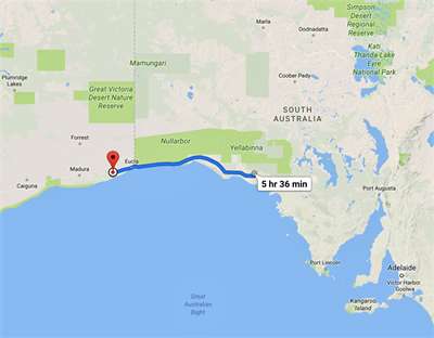
We were looking forward to exploring it. For today we satisfied ourselves with just the first 70 km
or so as the road took us through Eucla and up into the Hampton Tablelands. We
stopped for the night at Mundrabilla Roadhouse, the first time we had paid to
park so far on this trip. We thought it a good idea to plug into mains
electricity and charge the batteries up overnight, although we were fairly
confident they were fine from all the driving. And although we had been
using the on-board shower, we felt it wise to conserve water and enjoy long
showers at the campsite. At $20 for the night, it was a bargain. As we checked in at the office, we asked the guy to confirm
the time for us. WA is 2 hours behind Brisbane (3 behind Sydney) and we
had put our watches ahead by half an hour in SA to account for them being on
daylight saving (as opposed to going half an hour back during winter).
Now we were unsure if WA was on daylight saving or not. It was so funny,
because even the guy serving us didn’t seem to understand all the time
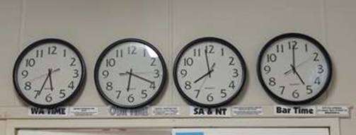
differences. On the wall they had four clocks, all telling different
times. The first was WA time, which starts at Caiguna, 300km
further along the highway to the west, across to Perth at the coast. The second was “Our time” – from the SA/WA
border to Caiguna – and where we now were. Officially, it is
Central Western Time. The third was the SA/NT time, which our watches were
currently on, and which was one and three-quarters of an hour ahead of
“Our Time”. So for us it was well into the evening, but it was still
broad daylight and early evening here. We had just gained almost 2 hours. The fourth clock, by the way, was our favourite time –
Bar Time. The sign said, “If it’s too confusing, it’s
always Beer O’clock in Mundrabilla!”
Clearly the Mundrabilla Roadhouse is used to travellers
asking what the time is!
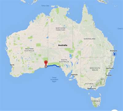
Google map showing today’s drive. Now
hugging the south coast as we cross into WA. |