Peros Banhos - Ile Diamant to Ile Coin including information on routes and anchorages

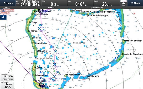
Position 05:26.867 S 071:45.874 E Date 1535 (UTC+5) Thursday 21 April 2016 Distance run 14.2nm over the ground We spent a quiet night, albeit for some of the night the wind went around to the east which put us on a lee reef but with a well set anchor and a fine set anchor alarm we slept secure. A quick check pre-dawn showed that the wind had gone around to the west again but also gave a wonderful sight of the sun just starting to illuminate the eastern horizon whilst the setting moon illuminated the western horizon both shining through breaks in the heavy clouds. Definitely no light pollution here. We had a short snorkel on the nearby reef before we set off and remarked on the large shoals of different types of fish and some good coral. There are no photographs today but a number of screen shots from the chart plotter may be of interest to those that follow.
The route from Ile Diamant to Ile Coin The route was planned using a combination of Google Earth KAP file overlays on OpenCPN and the electronic charts. We found that the registration of the chart, i.e. is the land where it says it is, was good which gave hope that some of the shallow bits were marked in the correct place. The light was not good due to an overcast sky but it was adequate to pick out the shallow bits. What we did find was that some of the shallow patches marked on the chart were not so shallow, 25m when 10m indicated on the chart, but the shallow patches that we saw on the ground were on the chart. C-Map and Navionics were very similar and would appear to have come from the same source. C-Map however states that depths within the atoll are almost entirely taken from a survey of 1837 and miscellaneous lines of soundings. Some shoal areas have been derived from incomplete satellite imagery; i.e. they used Google Earth as well perhaps. One of the features of Google Earth satellite images are clouds that obscure detail. For this area there are also darker patches which may be the shadow cast by clouds or something under the water. We steered around some of these black holes and crossed others but failed to detect anything abnormal. So no Higgs Bosoms here and apologies to CERN.
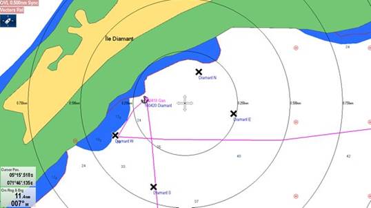
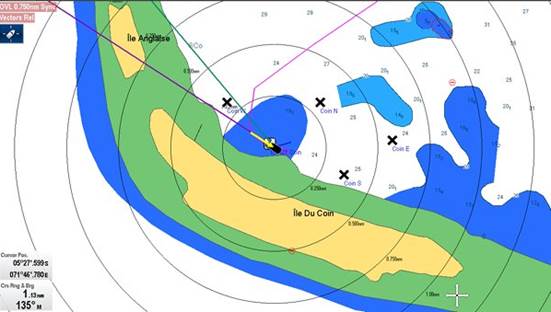
The anchorage at Ile Diamant. The black crosses are the boundary of the BIOT designated anchorage Both of these anchorages are deep for yachts and exposed to the East. Ile Diamant is exposed from North East through East to South West and Ile Coin from North through East to South East. At Ile Diamant we found sand at 13m far enough off the reef to swing safely in variable light winds. At Ile Coin having searched about and looking at the bottom on the fish finder depth sounder we dropped at 24m well off the reef onto what appeared a flat and therefore we assume sandy bottom where we held on 80m of chain.
The anchorage at Ile Coin Low water exposes a long sandy beach and a sand bank that joins Ile Coin and Ile Anglais. Both C-Map and Navionics, including the iPad version have tide stations for Peros Banhos. |


