Noumea to Kupang Day 0 - Let us try again
Position 22:08.29 S 166:13.08 E Date 1415 (UTC+11) Wednesday 30 September 2015 Distance run in 2hrs 30mins 16.8nm over the ground, 16.9nm through the water With approximately 2,800nm to go, setting off, doing 17nm and dropping the hook for the afternoon and evening may not seem like much progress but let me assure you that to us it is. Having once again finished repairs on Tuesday early Wednesday morning we moved over to the fuel dock, the photograph of this managed to find its way into yesterday’s entry, and Chloe collected our passports and took them off to Immigration and Customs to organise clearance out, again. Coffee drunk with and farewells made to Chloe we set off in a gentle 10 knots of wind on the beam and headed north west up the coast of New Caledonia with a distinct sense of déjà vu and fingers crossed that this time the furler would finally give in and behave itself. Taking the cover off the furler drive after anchoring showed that all was well and nothing had slipped; let us hope that that issue is now behind us. It certainly has taken a great deal of time and effort since it first started to play up in June off the coast of Malakula in Vanuatu. A pleasant afternoon and evening was spent at anchor in the bay at Timbea and we celebrated with an excellent pre-voyage meal of stuffed chicken breast.
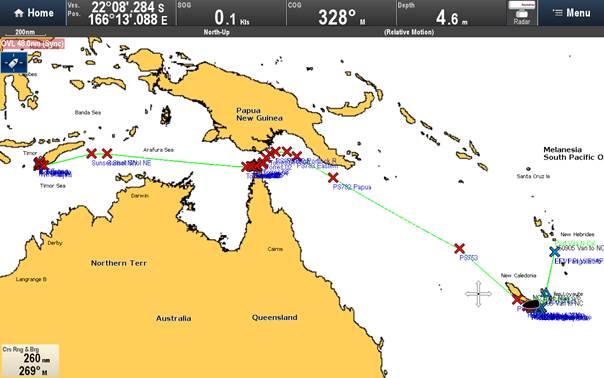
The chart plotter image of where we are and where we are going. The crosses are our waypoints, blue from Port Vila, Vanuatu and red for New Caledonia onwards. The route starts off as being 2,825nm, not dissimilar to an Atlantic crossing but with the fun of a chicane, The Torres Straits between Papua New Guinea and Northern Australia, in the middle. Destination for clearing in to Indonesia is Kupang which is 500nm east of Bali. |