Eastlands Bounteous Coastline
|
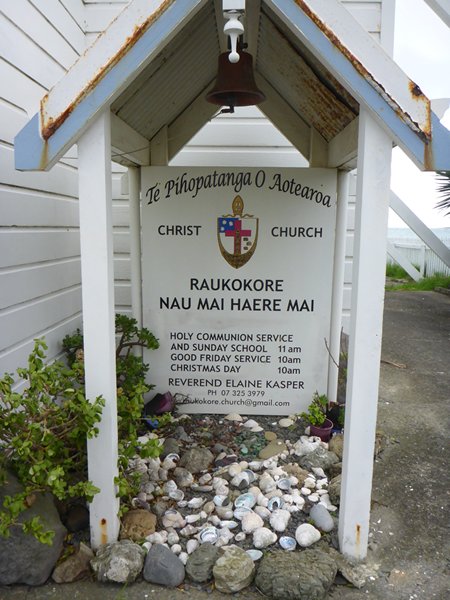
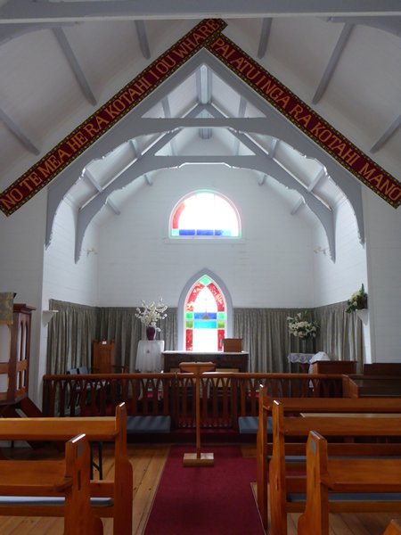
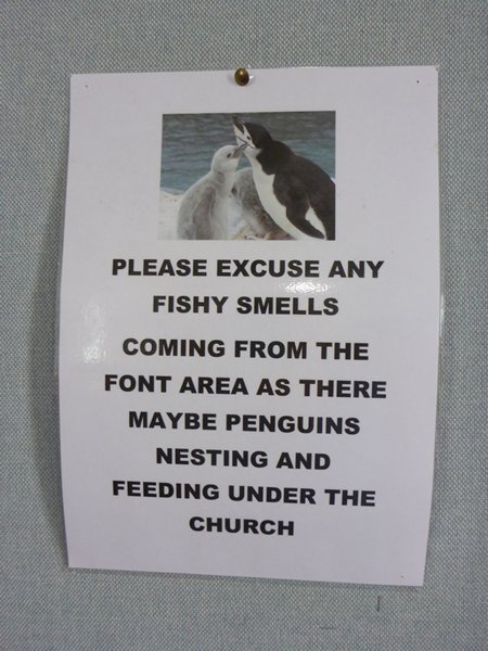
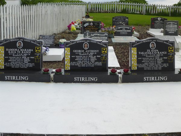
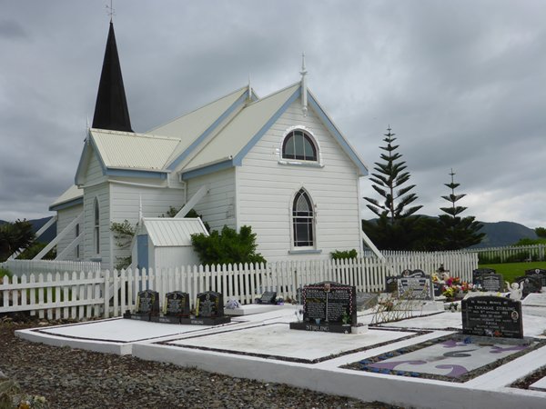
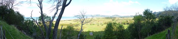
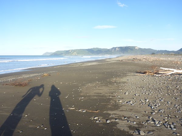
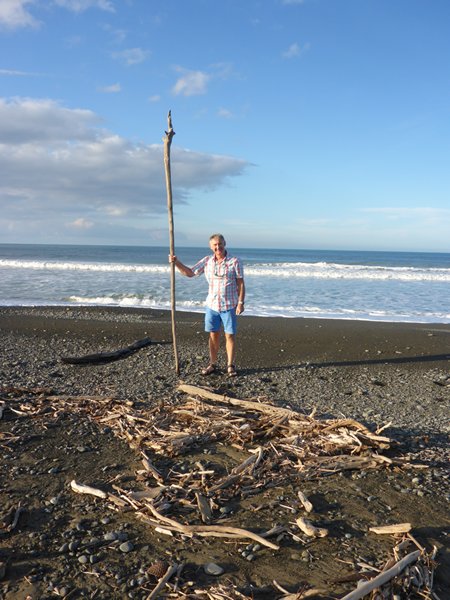
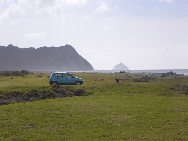
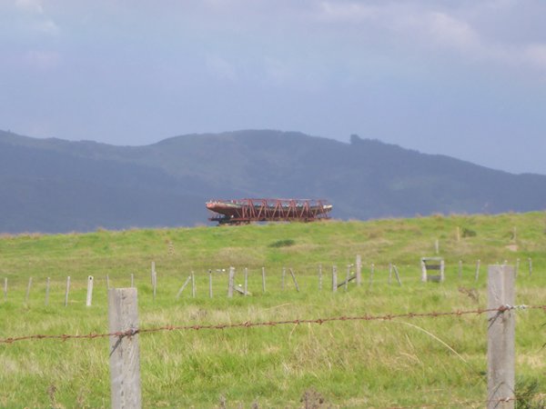
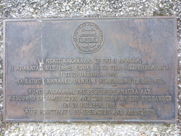
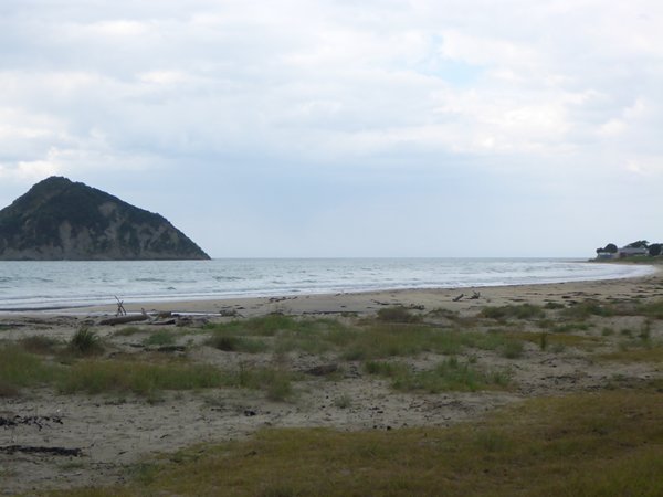
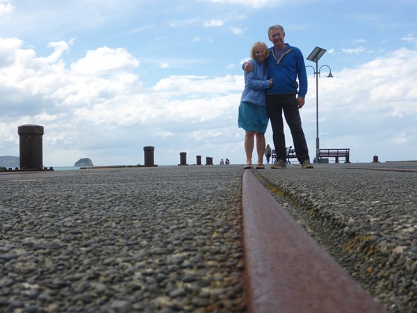
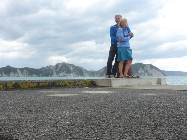
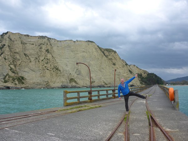
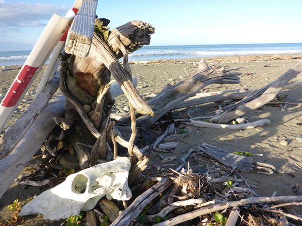
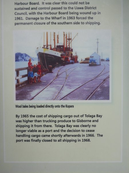
Eastwards to Eastland If you look at a map of New Zealand’s North Island the upward pointing corner of land on the right hand side is Eastland. Its coastline stretches from the shores of The Bay of Plenty to the west around the north coast from Cape Runaway to East Cape and down the Pacific coast to Gisborne on the Eastern shores. Roadwise it is served by State Highway 35 which passes through numerous historical Maori towns and villages such as Opotiki, Te Araroa, Tolaga Bay and Whangara to name just a few. Some of these towns are hundreds of years old, settled by the Tini-o-toi and Tini-o-awa tribes in the 12th century but recent excavations have found signs of much earlier inhabitations. Today the empirical evidence is of the ongoing ways of Maori living, looking after their community owned land and using the land to provide recreational activities for visitors and many kinds of small farming activities which run contrary to the intensive vast scale farming activities of their European minded neighbours. Those that haven’t integrated with urban pakeha lives that is. The fertile border of land between the shores of the Bay of Plenty and the South Pacific shores and the Raukumara Range of hills and mounts in the centre of the natural triangular land mass is where they grow maize, avocado, kiwi fruit and Manuka honey and where their sheep flocks and herds of fat and shiny Hereford and Angus cattle graze in small numbers on plenty of naturally watered pasture land. Apart from that this region is one of the most diverse we have come across for available leisure activities for visitors. Pony trekking centres, camping, hiking, backpacking, fishing and diving or just wandering around beautiful little bays and along wide tree strewn beaches with hardly another soul in sight. Harvests from the land and the sea, surf and turf and visitors. In a sense time has stood still here for the Maoris. Their most prosperous time was the 1850’s when fortunes were made sending produce by sea to the growing market in Auckland. The trade started with flax and whaling but soon large areas of native forest were being cleared for sheep production and that is where today’s livestock farms are still at work. We were on a whistlestop tour. The more we saw the more we realised how much we would like to return and spend weeks walking and learning about the area and enjoying its natural atmosphere where history is so much a part of the present day and a respect for the earth, where the people are its custodians and not its abusers, is unchanging. We stopped first in Opitiki whose name comes from the two fish pets called O-potiki-mai Tawhiti who were brought to the area from Hawaiiki by Chief Tarawa and his brother Tuwharanui. This town was a significant trading port before the building of the road. Stock would be brought to the port in wagons that were then backed a few feet into the sea so the stock could be loaded onto small boats which then floated the fearful creatures out to bigger vessels for shipment to market, this was called the ‘surf landing service’. The effect of the arrival of Pakeha from Europe along with Government forces was complex and happened at a time when there was still rivalry between different Maori Tribes. I could research a thesis on the subject but many others have already done just that so I just want to tell you about one aspect of the contact between European and Maori that was peaceful, productive and long lasting. At the pretty little Raukokore Church on the promontory beside Waihau Bay the Stirling family settled amongst the resident Maoris, who typically took up the Christian faith with honest hearts and married their visitors, living and working together in harmony as you can see from the architecture of the church and the testimony on the headstones, which was often the way before British rule took hold. Punishment for opposing the will of the British Government control was claiming community owned Maori land. One Maori chief commented that when Iwi fought Iwi the victors would then settle with the vanquished, but when Europeans were the victors they added insult to injury by stealing the land as well. I wondered what had happened to the three young men who died on the same day and were buried together, possibly an accident on the road or at sea or something else. The boom in sheep farming came to an end and many of the pakeha farmers moved away, which accounts for all the deserted churches and colonial style farm houses we saw. But the Marae (Maori meeting house and community centres) are numerous (more than 150 in Eastland) and beautifully carved and very much in use. Signs politely ask us visitors to be respectful of their homes and culture and we were but how I would have liked to learn a lot more and immerse myself in their peaceful, undemanding existence. Also explore the obvious Scottish presence in the area. The wind was rising as Tui sped up and down the many coastal hills. Our first night was at the Te Araroa Holiday Park on the Tokata Flats. The view from up the road before we descended was one of the many breath taking sights along this wild coast. We pitched the tent and then wandered past the grazing sheep to the wood strewn beach which stretched for miles with no one else in view. Amongst the arboreal flotsam were bleached bones and skulls of various sizes and recent deer tracks. My morbid curiosity was being well satisfied here! The area reminded me of the west coast of the south island around Greymouth and Hokitika, remember the “Oh dear there’s two dead deer here dear”. Both coasts face onto miles of sea, this one of course 6000 miles to South America, so I wondered if the wood came from this land or right across the ocean. I wouldn’t like to hit some of those trunks in Zoonie. We settled into the tent and sitting on the self-inflated mattress tried to tune into a radio station on our little black tranny for the 7.00pm news. Ah, success but oh dear its in Maori and we are ignorant. During the night a front went over with strong winds thrashing our little tent and then two downpours. But by the morning our tent was dry again as we packed it away, smug in the knowledge it had avoided the next downpours. An early chorus of Tui calling to eachother over the campground and Weka and Goldeneyes abounded in this charming camp. With the season at an end we had many places almost to ourselves with no queuing for loos and showers and the few other visitors made a point of having a chat. In the little kitchen four fellow campers were getting ready for the day. One of them ran a charter boat out of Waiheke Island at Auckland and he and his mates had come along to help one of them move into his newly acquired section near Westport on the south island. They were having a roundabout break on route. Outer jackets were not the only things I had failed to pack. As we planned to camp where there were kitchens I didn’t bother with saucepans, plates and cutlery, but there weren’t any here either. So we used loo paper for plates and were glad of the boiling water tank and the toaster which are provided in most camp kitchens. We did bring mugs, tea, coffee, marmite, jam and spoons and milk, butter and bread etc in our cool bag. So we were OK. Supper consisted of cheese and cucumber sandwiches, apples and red wine. Just fine. Next to us was a row of 1960’s touring caravans I recognised from my family camping days as a child and late that evening a Maori couple arrived for the night. I wondered if they were returning from work to the only place they could call home or maybe they were just on the move like us. Next morning, after a breakfast of toast, yoghurt, bananas and coffee, I noted in my little book ‘hydrangeas, lemons, walnuts and willow all grow so well here’. I could live here. Gin and Tonic with lemon and limes, nuts, corn on the cob, kindly tended bees making tasty honey, the list goes on. It was a gravel road that led to East Cape and the lighthouse. It is the most easterly point of land in NZ and on a Longitude of 178’29’20E it must be at least one of the most easterly points of mainland in the southern hemisphere, allowing for the eastern Fiji Islands. The road is described as a dramatic scenic drive and I would have liked to have done it but not in a lightly build friends’ car, so we took a left turn off the highway to the beach at Rangitukia and saw East Cape Island off the lighthouse point, but the mainland on the left of the photo masks East Cape from us. Never mind Tui was safe. Larksong filled the air and healthy shiny horses grazed this beautiful area around where the Waiapo River meets the sea. A fine Waka war canoe sat atop a hill in its cradle awaiting the next ceremonial event and racing season. I couldn’t get near enough to have a good look. As we sped on southward Mt Hikurangi at 1752 metres rose above the surrounding mountains of the range and the farming area was broadening and flattening out. We were moving away from small farms. Signs for Hurangi Forest Farms kept appearing near damaging logging operations and I wondered who owned them and on later research found they are Malaysian owned. (I’ve been reading Peter Wohlleben’s ‘The Hidden Life of Trees’ and learning how little we know of the damage our interference of any kind in forests does to the forest floor). We knew a big storm was coming, winds of over 200kph were being experienced on the west coast but it was not classified as a cyclone because it was approaching from the west across the Tasman Sea and not from the Tropics to the north.(!) There had been a tornado in Taranaki and a dairy farmer had to hang on to the machinery in his parlour or be blown away. Our road map showed a Cook landing place at Anaura Bay and reading his log and the plaque set back from the beach we learned it was a friendly greeting the local Maoris gave the gentlemen unlike the occurrence he had just experienced as the Endeavour skittered out of Poverty Bay further south in Gisborne. However not much produce was to be obtained here as the season was wrong for the local staple of kumara. Cook’s crew were always in need of water, wood and grass for the animals and any other fresh edible produce they could find. He found that the soft fleshy interior of Cabbage Trees as he named them were effective in preventing scurvy. In Maori Ti Kouka or formally Cordyline Australis, the Maoris used the scraped leaves as dressings and the tender inner shoots for milk stimulation in nursing mothers, I wonder if Cook fed them to his goats! I described the early method of getting livestock onto small boats to be taxied to the offshore vessels known as the surf landing service, well it was a precarious and dangerous procedure so in bigger ports like Hicks Bay and Tolaga Bay long jetties were built out into the surf of the Pacific to a depth where the bigger ships could tie up alongside and stock would be delivered by train along the jetty. The wealthy past that grew from this industry is evident in the size of the Hotel we stopped in for a late breakfast at Tolaga Bay where the present owners are planning to turn it into a hub of the community to include an information centre. The wealth is also reflected in the length of the recently restored pier, 660 metres long and providing a pleasant post-industrial stroll for today’s visitors, us included. We knew we were missing so much in our rush through the area but the storm was marching closer from the west and we wanted to be secure somewhere pretty soon. As it was Tui was driving through an almost solid wall of rainwater with strong sidewinds buffeting her. State Highway 35 bypassed a town called Whangara. I had seen the name on billboards fronting farming areas in the region and found they are owned by two influential Maori families. More evidence of their thriving nation both independent from but also infused with present day New Zealanders. The internationally acclaimed film ‘Whale Rider’ which we have on board Zoonie, was filmed near here and this area, partly because of its proximity to Gisborne, is now home to much creative media activity with a film festival held at Wairoa. Fifty years ago the New Zealand Maori Arts and Crafts Institute was formed by Act of Parliament and their cultural activities are going from strength to strength. The fusion with the Pakeha equivalent is fruitful for them individually and as a whole. Keisha Castle-Hughes who played Pai in the film also appeared in Game of Thrones as the warrior Obara Sand. There were road works all down this coast and from what I could see cables for fast broadband are being laid bringing the entire area into the 21st century of internet communications.
|