Caribbean Circuits
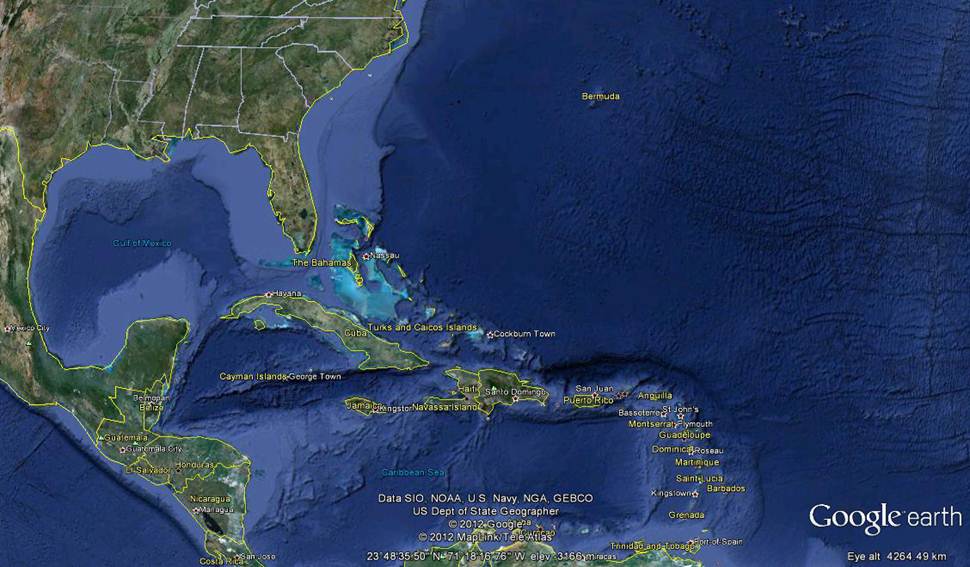
Looking back in our log we left Antigua for Bermuda in April 2011 and now we are back after about 6,000M. Would we do it again – No, it was “a bridge too far”. We could have done it if we hadn’t lost 4 weeks with repairs in New York, 2 weeks for warranty in Charleston and a few days in Annapolis for Beneteau Warranty Inspection. Then we stayed at Solomon’s Island where we hauled out the boat and went back to the UK for a 6 weeks. At least we got as far north for the beginning of summer and then moved south as the Artic Front swept down from Canada, we did get some cooler days – really freezing cold at Cape Hatteras. We decided to go this route because after Brazil we wanted to continue the adventure, most of the other RIDS boats also have wanderlust and have gone off around the world, many are now in the Pacific and 4 other friends are going next season (but we are NOT, almost certainly). We were also unsure of hurricanes, but having had a season watching, tracking and being hit by Hurricane Irene we feel more confident about leaving our boat in the Caribbean all year. So it is possible, we did it, but it’s not really practicable – here are our thoughts for future planning 1) The trip to New York doing the East Coast of the USA and sailing down the “Thorny Passage”, see Bruce van Sant’s book “A Gentleman’s Guide to Windward”, is too much in one hurricane season, unless you can spend all the time with your boat – but we all need a break sometimes. Coming down through the Bahamas in January means the weather is still cool, around 20-25 degrees and it is well over 1,200M to the BVIs against wind and current and this year the winds have been much stronger and more easterly than usual making it especially difficult. 2) Stay in the Caribbean and lift out into a cradle and go home, or stay with your boat and sail away south west if you see a Tropical Storm developing and heading your way – keep checking NOAA every day at www.nhc.noaa.gov
3) A better plan could be to split the region into 2 and do it over 2, not necessarily consecutive, seasons Plan A) Antigua to Bermuda then up to New York during mid May, before the hurricane season starts, you arrive as the weather will start getting warmer, although in May you may still need a fleece if the sun isn’t shining. By July and August it’s too hot and the murder season starts, so you should leave the city to do Long Island Sound, Marthas Vineyard (officially the apostrophe has been dropped) maybe Cape Cod, Maine and even Nova Scotia, Canada if the weather is OK and you think you can avoid the crab pots in very thick fog. Then leave to head south towards Cape Hatteras, up Delaware Bay (nothing there, just one nuclear power plant) and through the C&D Canal (all bridges are 40m clearance for cargo vessels) into Chesapeake Bay (which is really pretty). This route means you only have to go upwind and against current from Sandy Hook at New York to Cape May at Delaware Bay, only around 120M. Once down to the mouth of Chesapeake Bay you sail back to the BVIs from Hampton (across the river from Norfolk VA) heading out east to what our American friends call “I65” (longitude 65W) and then drop due south into the BVIs – this is the route taken by the Caribbean 1500 in mid November when the hurricane risk should be less, both routes work well crossing the Gulf Stream. Just don’t go around Cape Hatteras in more than 10kts of wind, it will be double or triple any wind strength when you arrive, with the Chesapeake and Gulf Stream currents fighting for supremacy at your expense. For those of you needing a mini refit Annapolis is a good place, you can even pick up a rental and do Washington at the same time. For those of you with a draft of less than 6ft and an air draft of less than 65ft you can always take the ICW from Norfolk down to Beaufort and remove Cape Hatteras and Cape Lookout from the equation. I hear it may drive you mad though, as progress is very slow with the risk of hitting shoal banks, having to cope with other vessels and waiting for bridges to lift. Plan B) Leave from Eastern Caribbean in Spring, before the hurricane season starts, and go up the way we came down, BVIs, Spanish Virgin Islands (which aren’t Spanish at all and belong to Puerto Rico), Puerto Rico (remember your ESTA validated in a US Territory direct by a commercial vessel – or better still get a B2 visa), then Dominican Republic (a MUST) and the south coast of Cuba. That way you can always head south west away from any hurricane, if you go to the Bahamas then you will find someone has put a 700M sand bank in the way and you could be cornered like the proverbial rat, except worse you would be on a lee shore. From the south coast of Cuba you go round to Hemmingway’s Marina on the north coast and then cross the 90M to Florida Keys, unless you are an American, in which case you will be taken straight back to Guantanamo Bay at the eastern end of the island “for the duration of your natural days”. Then you ease your way up the coast of Florida crossing from Miami, Fort Lauderdale, Palm Beach or even going as far north as Charleston, about 380M north of Palm Beach, and then go out to “I65” anytime after mid November and down to the BVIs. If you need to have any work done on your boat then Fort Lauderdale is a huge boating centre and you can source most products and services here, including the biggest West Marine you have ever seen. Not quite sure what you do if a hurricane comes your way when you are in Florida, as there is nowhere to run to easily, as we cannot get inland very far as we soon run out of water and come to fixed bridges with our 2,6m draft and 24m air draft. |