Too Much Excitement! Vitogo Bay 17 33.73S 177 29.43E
Aurora_b
Mike and Liz Downing
Wed 25 Jul 2012 08:21
|
With a forecast of winds going from the
southeast round to the northeast we decided it probably wasn't a
good idea to make the 50 mile passage along the north coast of Viti Levu,
between the fringing reefs and the outer barrier reef, to Lautoka (Fiji's
second largest city). The route has some twists and turns with few
markers and not having done it before, the added complication of an onshore
wind was not something we wanted, particularly as it was due to come back
round to the southeast in a couple of days. So it was a couple more days
anchored at Nananu-I-Ra island. The northeasterly didn't happen
and the wind actually dropped out completely and the sun shone. So 2
lovely sunny days with a flat sea. It would have been the ideal time to motor
along the channel. Never mind, with a south easterly of 15kts forecast
for today everything was set for the passage, that was until
04.00 this morning when the wind alarm woke us and it was blowing 20+ kts
from the south. By 08.00 it was blowing 30kts gusting to 40kts and shortly after
35kts, gusting anywhere between 40 and 50kts. The anchorage
has a long fetch to the south so although protected the seas quickly
built up causing the bows to pitch up and down in what was now a surf of
white horses and spray. Just to make it even more 'interesting', with winds
from the south the anchorage became a lee shore with not a huge
distance behind us and the reef. It was clearly not the day to go
- it was totally overcast with just too much wind,
waves, white horses - it would be impossible to see the reefs, but we did
have to move to a more protected anchorage, and one
with more clear water behind us, in case the anchor dragged in the
high winds.
Getting the anchor up in winds of that strength is
definitely not fun! It has to be a team effort. Me on the pitching bows
operating the windlass and giving sign-language directions to Liz on the helm.
It's essential to motor forward in the right direction and at just the
right speed to ease the strain on the chain so the windlass stands a chance
of bringing it on board. In 35 to 45kts of wind there's absolutely no point
in trying to shout instructions! But we got it up and got away from
the shore, heading west along the channel a few miles to what seemed
on paper a much better anchorage. However, once there the fetch seemed
almost as great and anchoring in those winds and seas with coral
potentially all around was too much of a lottery. So keeping
going west along the channel seemed the safest option, following waypoints
on the chartplotter and following our position and track on Google Earth on
the laptop. Luckily the channel is generally wider than it looks
on the chart, but it would have been nice to see the reefs either side of
us. The seas were too big and rough to see anything under the water. Even
with no sail the gusts were strong enough on the beam to heel us well over.
So it was on a further 8 miles to the next possible anchorage, but it was the
same situation and safer to keep going. It was the same
story again at the next two potential anchoring spots, until 6 hours later
when 1 mile to the west of Vatia Wharf, having travelled 31
miles! Within 10 minutes the wind changed from 25 to 30kts
from just east of south, to 6kts from the west, the seas calmed down and we
could anchor, but there didn't seem much point; with only 19 miles
to Lautoka we might as well continue. And so it was that we did
our longest ever passage within the reef in appalling conditions and didn't
see the reef once all day! At 17.30, just before reaching
Lautoka, we pulled into a deserted Vitogo Bay (pronounced
Vitongo). It's about 2 miles long and 2 miles wide and surrounded
by mangroves. Generally where there's mangroves, there's mud and where there's
mud there's no coral. The anchor was dropped right in the middle of the
bay - so loads of room all round us! At 30ft, it's the shallowest
anchorage we've found since arriving in Fiji and the lovely mud should
make it excellent holding. Having dropped down, the wind and sea
stayed down and after the noise and turmoil of wind and sea earlier in the day,
it is so quiet and peaceful here, all on our
own.
 How the chartplotter shows part of the north
coast. Green is reef and our track is in
red (we
saved our track as a course and the
software inserts lots of waypoints, the crosses,
to create
the course, many
more than we had or
needed).
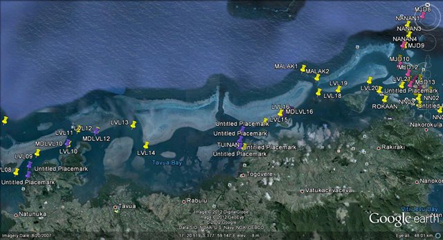 The Google Earth picture of the start
(eastern end) of the passage with the waypoints that
we actually
used.
 The western end of the passage. With
all these blocks on Google Earth pictures and
chartplotter
you build up a 3D picture of the route in
your head, but when out there it is of course all
under
the water, so completely flat, and nothing
like you imagined. On a good day you can see the
reefs under the water which is a great help,
but with our conditions we didn't see a thing - just
waves, white horses and lots of
spray!
 Peace and quiet, anchored all on our own in
the middle of Vitogo Bay, just north of
Lautoka.
|