North Island Tour: To Wellington and back to Auckland
|
Over the next three days we were on a bit of a mission, we had arranged to meet up with Sarah’s cousin’s son Ben who came out here to work and also friends Rob and Jo who were passing through on return from a south island tour. We passed by New Plymouth last time we were down here but decided this time to have a look, things to see were; The Wand, an art work on the seafront, the sea front walkway with the Te Rewa Rewa bridge, climb Paritutu rock and visit the Puke Ariki museum and the Govett-Brewster art gallery. The Wand had been removed for maintenance, the track up Paritutu rock was closed, we did walk a bit of the walkway and camped close to the Te Rewa Rewa bridge but only managed one gallery of the museum and not the art gallery, so still more to do if ever we are down this way again.
New Plymouth Coastal Walkway with Paritutu Rock next to the chimney at the end.
Te Rewa Rewa Bridge, on a clear day you can look along the bridge and frame Mount Taranaki in its arch but not today.
Govett-Brewster Art Gallery Then on toward Wellington, we decided to follow the coast route which was a bit of a mistake on a day with heavy rain and poor views, it also took a long time. With one overnight stop at a very nice and cheap motorcamp $20 for a powered site and hot showers it was probably the cheapest site we have stayed at. In Wellington you have a choice of small free sites in the city or the motel just outside, we opted for the motel which we had used before, they have excellent facilities and spaces for about 20 campervans. We met up with Ben in the afternoon and walked up Mount Victoria with him, then took a scenic drive all round the city coastline before having a meal in the Cuba Street. Thursday, Rob and Jo arrived on the ferry and we had arranged to meet them for a meal at a vegan restaurant, again on Cuba Street. Having a whole day to pass we went to the museum and then up on the cable car to the botanical gardens, real tourists!
View of Wellington from Mount Victoria
Wellington sea front
Masks had to be worn on the Cable Car Having visited the northernmost point on North Island when we first came here in 2017 we wanted to visit Cape Palliser at the southern end. This involves a long drive looping north up the Hutt valley then south east onto a no exit route along the coast. The wind was blowing and standing at the lighthouse you almost had to hold on.
Cape Palliser Lighthouse
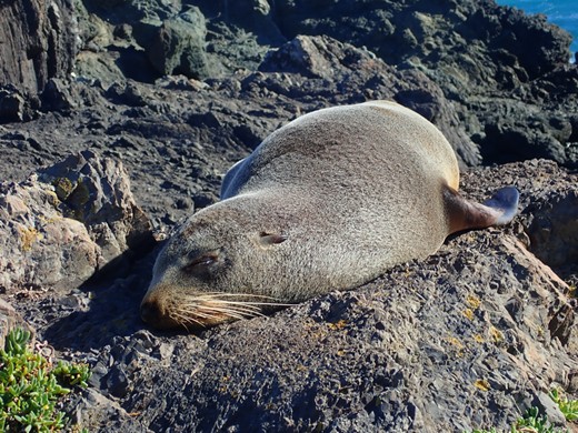
Cape Palliser is home to a fur seal colony and we spent time watching and videoing the seals and pups. Back out the route we came and fabulous views along the coast and a night spent at a campsite by Patangirua Pinnacles, an excellent example of ‘Badlands erosion’ and used for Paths of the Dead sequence in the Lord of the Rings film.
Cape Palliser coastline
Patangirua Pinnacles Continuing a lighthouse theme as we travelled north we headed out to Castle Point and Deliverance Bay. The point like many places in New Zealand was name by Captain Cook and the bay by Reverend William Colenzo who landed here after days of tacking up and down the coast waiting to enter the Cook Strait against the stormy westerly winds.
Castle Point lighthouse, the tallest on North Island with the cove to its right.
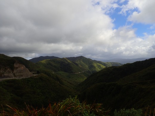
An unusual sight on the rocks leading to the lighthouse, a group of women posing with a pole. It was a freezing cold windy day! We now had three days to get back to Auckland with the campervan and wanting to avoid the main roads as much as possible we drove up the Manawatu Gorge, a scenic drive, stopping for a short walk and then a visit to the glow worm caves. The caves were a long way off the surfaced road along a single lane metalled (gravel) track, about 7km. More a ravine than cave, being daylight there were no glow worms to be seen.
Manawatu gorge scenic drive
Glow worm caves Manawatu scenic drive was compared on line to The Gentle Annie road from Taihape to Napier so we decided that we had to experience that as well, also it took us off state highway 1. Signs at the end of the road warned that it was closed for bridge repairs on weekdays from 0900 hrs and it was late on Sunday afternoon by this time. We had a choice of campsites along this route, the first was 45 minutes drive and before the roadworks while the other was an hour and a half drive, but just past the bridge repairs, so rather than making an early start to get over the bridge before work started we elected to use the second camp just after the bridge. This was a really nice DOC site, massive area with only a few other campers dotted about close to the river with good loos, all for a donation in the box.
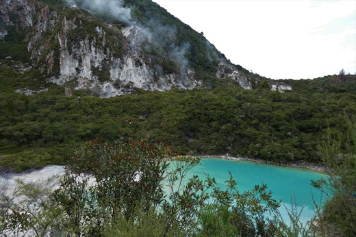
Kiripapango campsite A short stop in Napier, the Art Deco city we had been to before, and then press on passed Taupo to camp alongside Lake Rerewhakaaitu south of Rotorua and within the volcanic area. Steam is seen issuing from the ground from before Taupo all the way to Rotorua. We went to look at a lake on Rainbow mountain which is said to have bubbling mud and steam rising but you couldn’t get much of a view of the lake.
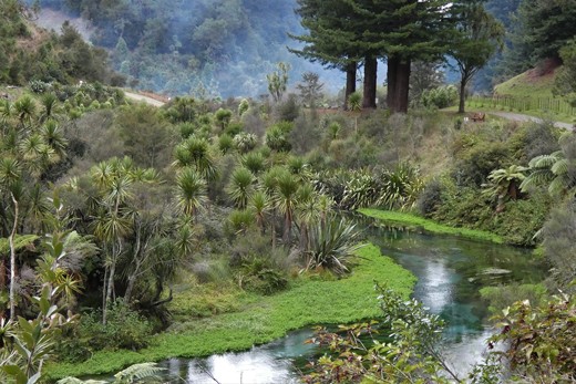
Crater lake on Rainbow Mountain We had one more scenic stop to make on our way north, this was at The Blue Springs. The spring is fed from the Mamaku Plateau and the water takes up to 100 years to filter down. The water is so pure that it is used for about 60% of new Zealand’s bottled water it is incredibly clear and a light blue in colour.
The Blue Springs Our final stop just south of Auckland gave us time to clean up the van and then to save cooking we found the only place in the area for a meal, The Ramarama Country Inn conference centre, motel and truck stop, or at least the number of trucks and vans parked up here made it look like a transport café from England. The food was also comparable in size, a massive plate of fish and chips, too big for either of us. Sent from Mail for Windows 10 |