Going North to head South, Kari Kari Peninsula: 34:49.16S,173:23.5E
|
Our planned 2 day lift out extended to 5 days due to the holiday weekend and the bad weather. After being lifted on Friday it wasn’t until Monday that the rain eased sufficiently and we were really able to start work, however we managed to get 2 coats of antifouling on during Tuesday and were ready for relaunch on Wednesday. The yard were keen to get rid of us as they had a queue of boats waiting to get in! We had a hire car over the weekend which allowed us to do the shopping we needed, including filling our gas bottles and buying a new anchor. We decided to update our anchor after we dragged it in strong winds in October and have bought a more modern design called a Rocna that is reputed to hold well. On Sunday night we drove out to Tamaterau for a meal with some local friends, Jane and Peter and Colin and Marjorie. Jane, with her first husband, Colin and Marjorie sailed to New Zealand arriving in the late 1960s and since we met them all they have been so welcoming.
Being relaunched from the Travelift As we had been able to do all the shopping we needed while in the yard we didn’t bother going back to the Town Basin marina but anchored down river in McLeod Bay for a couple of nights while we scrubbed the boatyard dirt from the decks. The yard in the rain was a filthy place and mud had been trodden everywhere. Then on the 29th of October we motored out of the river and turned north again. It was a day of some good sailing and some frustration as the wind went from almost nothing to 25knots and then back again but we persevered and covered the 50 miles to Whangamumu harbour then, a couple of days later, we made the short hop round to Bay of Islands to anchor in Waewaetorea Passage, at the northern end of Urapukapuka Island. We met up with the crews of Larus and Perigee for a walk ashore before moving on as we were a bit exposed to the swell coming through the passage.
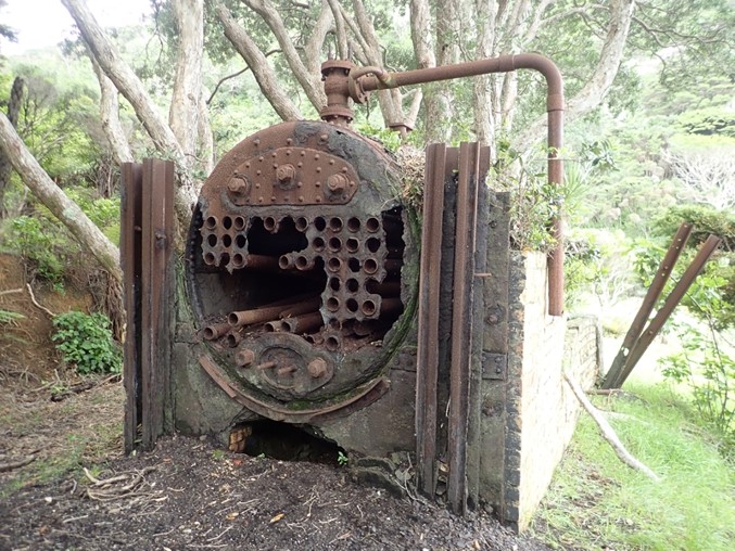
Whangamumu Harbour was the sight of a Whaling Station and the ruins are still visible. All the main walking tracks around the harbour are now closed to prevent the spread of a fungal disease in the Kauri trees so our walk was restricted
to the beach and ruins
We spent the next 2 weeks floating round Bay of Islands having some lovely sails between the islands, catching up with old friends and meeting some new people. With the start of the South Pacific cyclone season a number of crews have decided to accept the conditions that New Zealand have set to allow private boats through the otherwise closed border (mostly agreeing to spend at least $50,000 on work to the boat) and there has been a steady stream of new arrivals. Our hope now is to sail to the South Island for the summer. From the Bay of Islands on the east coast of North Island the shortest route is to go around the top of North Island and down the west coast (just under 500 miles as opposed to
about 630 miles for the east coast route) but you have to time the tide right around the top of North Island and do the miles from Cape Reinga to Nelson without stopping which requires the right weather window. To reduce the distance we came further north
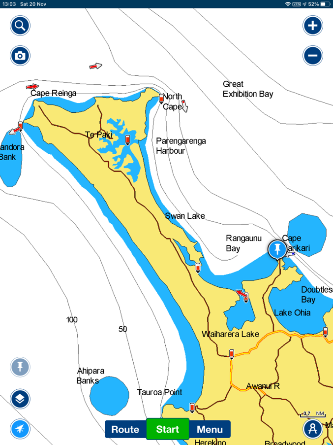
and spent 2 nights with Rebell (who are also looking to go south) in Whangaroa Harbour. We thought we would be able to leave on Tuesday next week, but the forecast has now changed and Thursday seems more likely. In the meantime we have come up to Karikari
Peninusla, just 30 miles from North Cape and hope that the weather will allow us to stay up here and explore the Far North a bit while we wait.
We walked to Dukes Nose while in Whangaroa Harbour..
with views from the top down to Serenity. Rebell and a visiting pirate ship in the bay below...
and out of the harbour entrance toward the Cavalli Islands
The Karikari Peninsula and the land north to Cape Reinga and North Cape is very low lying compared to the Bay of Islands and Whangaroa
Low lying land to our east gave us fantastic views of the sunset last night, and we also had a good view of the lunar eclipse
Its 30 miles from our anchorage behind Cape Karikari to North Cape and we need to time our passage to fit in with the tidal streams around Cape Reinga. If the weather allows we could go past North Cape and anchor in Spirits Bay, immediately to the east of Cape Reinga. The cape is highly significant to Maori as after death all Maori spirits travel to the pohutakawa tree below the light
house where they descent to the underworld (Reinga) by sliding down a root into the sea. The spirits then travel underwater to the Three Kings Islands where they climb to the highest point to bid their farewell before returning to the land of their ancestors,
Hawiaiiki-A-Nui |