Reunion 2
VulcanSpirit
Richard & Alison Brunstrom
Wed 4 Nov 2015 12:52
This Blog is about the magnificent mountain scenery of Reunion. Reunion is a volcanic island, created by three volcanos, one of which is still active. The island is young, about 2-3 million years old, and of very dramatic aspect because of the very complicated volcanic activity which has shaped it. There is a central peak, the Piton des Neiges (Snowy Peak) at 3071m, surrounded by three ‘cirques’ (bowls). These are not glacial, but rather the result of a cataclysmic eruption about 70 000 years ago which blew up the whole of the central part of the island. Many cubic kilometres (!!) of material were ejected, the central peak was reduced by about 1000m and these cirques were left. Fierce tropical weather erosion followed and continues to this day. The central rocks are a mixture of very hard and very soft, leading to some quite amazing landforms - and some of the best mountain walking available anywhere in the world. Being French, walking has been well developed with over 1000km of well maintained walking trails including three multi-day hikes supported by a network of gîtes. Reunion’s upland forests survived European arrival and are wonderful - the best we’ve seen since NZ. The key tree is the tamarind. Despite its name this is not a tamarind at all, it’s an acacia - Acacia heterophylla in fact. As this blog has pointed out previously, modern genetic analysis is revolutionising biogeography; what it has revealed on Reunion is astonishing. The Reunion tamarind originates in Australia. From there it got to Hawaii, evolving into a separate species there. From Hawaii it came 18 000 kilometres to Reunion - about as far away from Hawaii as it is possible to travel! And evolved into a third species, but one very very similar to its Hawaiian parent. All of this must have happened recently, Reunion only being suitable for colonisation in the last 2m years at most. It is presumed that migrating seabirds are responsible as the tamarind seeds are large, do not float and cannot tolerate immersion in seawater. But what a trip. Here is the tamarind forest:     As you can see this is a moist forest. The second photo shows a tamarind, while the third is a view over the high plateau tamarind forest showing the cloud gathering in the afternoon - the tops are clear until lunchtime every day, then covered in cloud right down into the cirques in the afternoon. It is this combination of tropical heat and wet cloud that has allowed the forest to develop. Note too the typical southern hemisphere tree ferns. Your correspondent is seen in the last photo above, on a boardwalk through the forest en route to the Trou de Fer (Iron Hole), one of the wonders of the island. Here it is:  Doesn’t look like much initially, just a nice waterfall. But look again; in the photos below are helicopters giving you the scale for the same waterfall as in the upper photo:   And we did the helicopter ride. Talk about unforgettable. Here we are, on the left below entering the Trou de Fer aiming for the deep basin in the shot above:   And on the right above, climbing out over the Piton des Niege aiming for the Piton de la Furnaise (Furnace Peak) which is the active volcano:   It is erupting at present so the paths to the crater are all closed. This is one of the world’s most active volcanos, with almost constant activity. Lava regularly runs into the sea, severing the coast road - but all the time it is bubbling on like this the risk of a catastrophic eruption is much diminished. There are three cirques, each very different. The Cirque de Salazie is in the west, and is by far the wettest. In the south is the Cirque de Cilaos which has a very alpine feel, while in the northwest is the Cirque de Mafate. This is the driest, and has no road access at all. Everything must go in and out on foot or by helicopter. It is a walkers’ paradise. Here is Salazie:     The first photo is looking north from the south rim, early in the morning. by lunchtime this whole bowl will be full of cloud. The high rainfall gives rise to a lot of waterfalls, including the Trou de Fer. Then Ali hiking on part of a long distance path, and finally looking up towards the col leading north to the Cirque de Mafate. The large rock on the skyline is known as Pluto, for obvious reasons. And then Cilaos: 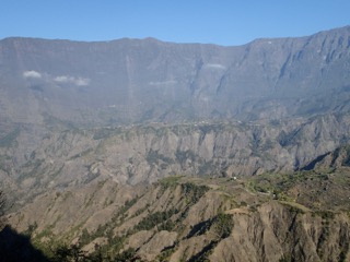   This is quite heavily populated (6000), with smallholders farming lentils in particular. The cirque was first occupied by escaped slaves who lived on the small flat areas known as Ilets - islands. Erosion here is a formidable challenge as you can see in the photos. The cirque’s rim in the background is at about 2500m. Everything here comes in along a quite exceptional road dating from only the 1930s. Before that it must have been very remote indeed. There are several tunnels. The third photo shows a delivery truck negotiating one of them. It has a clearance of only a couple of centimetres each side, and the entrance is not straight; getting himself lined up correctly took several minutes. And so to the jewel, the Cirque de Mafate. Here is is from the rim at Maïdo at over 2500m:    To get here one catches a bus at 0600hrs which arrives at the summit an hour and a bit later, for the incredible sum of 1Euro each. Public transport as it ought to be. This view disappears into cloud between 0830 and 1200hrs, every day so an early start is essential. The first photo is looking south towards the col leading over into Cilaos; the second is looking north down onto the Ilet des Orangers, seen in the early morning sunshine; the third is looking down and south onto the lovely village of Roche Platte. A precipitous path leads from the rim down into the cirque; the first photo below is taken from it. The second shows the village at Ilet des Orangers where your correspondents stayed overnight in a gîte, and the third shows the breakfast view the next morning.    The last set of photos shows a range of views taken in Mafate around the valley of the Rivière des Galets which drains down to the sea at Le Port where VS resided.   The first two are in the valley bottom, looking up into the cirque and then down onto the valley floor (note people on far bank of river by stepping stones for scale), while the remainder are views taken on the aqueduct path, a 12km level walk along the side of a cliff, airy in the extreme in places.    This whole are is just lovely, and I think almost unknown outside France. Definitely one to revisit. So that’s it for Reunion, now it’s off to South Africa. |