Saba "17:38.1N 63:15.4W"
VulcanSpirit
Richard & Alison Brunstrom
Tue 8 Mar 2011 00:17
|
Saba is an extraordinary place. The peak, Mount
Scenery, is the highest point in the Netherlands at nearly 900m and is covered
in cloud forest. The population of 1500 is indeed boosted by the presence of 500
medical students in a new university medical school - talk about an unbalanced
society.
The first photo shows the island from the leeward
western side. Note the v-shaped notch towards the right. The second picture
shows this notch. Until the 1940s the only way on to the island was via the
Ladder, a staircase path with over 800 steps that can just be seen winding
its way up from the beach towards the little building in the trees which was the
Customs House. Literally everything coming or going had to use the Ladder. A
grand piano was once carried up. Landing on the beach is hairy, and often
impossible for days at a time. There are two 'villages', Bottom which is at the
top of the path in a fertile hollow, and Windwardside which is perched on the
other side of the island on ridiculously steep slopes. The view from the east
looks more like the Faeroes than the Caribbean.
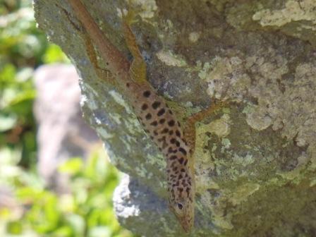
The last photo shows another nice
little lizard of unknown species because as you know it is my opinion that
a good Blog can't have enough lizard photos.
We left Saba on Sunday evening and sailed overnight
to the British Virgin Islands, arriving at 0730hrs (1130hrs UT/GMT) only to find
that it's a Bank Holiday here.
|