Blow Holes and Waterfall Dodging, Part 1 - The South Island West Coast, New Zealand
Harmonie
Don and Anne Myers
Sun 5 Apr 2009 06:46
|
42:26.988S 171:12.889E
The South Island's west coast was so
incredible it had to be broken into two parts in order
to share all the best pictures. Here's Part 1:
March 10th, the four of us piled ourselves, our
luggage and our brand new chillie bin (cooler) filled with mostly Dad-approved
food items into our highly serviceable rented Toyota Camry, and left
Blenheim behind as we headed west in search of scenery. The day was
cloudy with rain threatening, but our spirits were high because we knew we were
headed for some incredible sights and besides, rain on a designated travel day
really isn't such a bad thing.
Along the way, we stopped for lunch in the town of
Reefton, population 1,050. It was late for lunch (after 2pm) and the
restaurant's owner acted surprised to see us when we opened the door and stepped
into what appeared to be part restaurant kitchen, part family living room.
The initial quizzical look we received from the owner was slightly
reminiscent of the greeting Dorothy and her three friends received from the gate
keeper when they finally arrived at the city of Oz. However, once our
host realized that we really did want to have lunch at such an odd hour, he
recovered his manners and gestured toward the outside tables and bellowed, 'Pick
a table!'. There was a wet chill in the air and it was drizzling
fairly persistently by this time, so we asked if he had any indoor
seating. 'Oh! You want to sit inside?' asked the owner wearing only
baggy shorts, a t-shirt and a perplexed look. 'Yeah, yeah! Right
through there!' he pointed. We wove our way through the empty
outdoor tables to what looked to be a converted porch. Inside the sliding
glass door, there were a few more empty tables and one filled with a
couple from the US looking equally chilly and amused. Our host trudged
back and forth between the restaurant kitchen/family living room and the
converted porch through the outside seating area and although this seemed to be
quite an effort for him, he was certainly cheery enough about it and was
happy to provide us with a pizza, panini and Dad-approved toasty (toasted
ham and cheese sandwich). After we finished and paid the bill (with no tip
- yet another reason to love New Zealand), our happy host provided us with all
kinds of advice as to where to head next instead of proceeding
directly to our motel in Greymouth per our original plan. We
found this to be the case throughout the South Island - particularly in
out-of-the-way places like Reefton. The locals, sometimes a bit wary at
first, were generally happy to give us advice, directions or just chat about
where we were from, and most importantly, what our impressions
were of their country. It was obvious what they all thought of
their marvelous country and we always agreed.
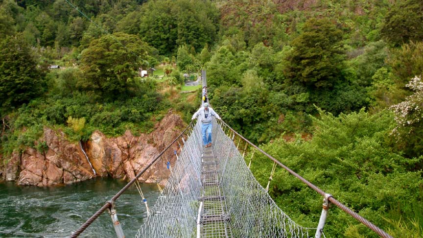
We followed our happy host's advice and drove
through the Buller Gorge to New Zealand's longest swingbridge at the
eastern end of the gorge. The gorge probably would have been gorgeous, but
the clouds covered the top half of the mountains so we couldn't see much.
The trip did give Don about three additional hours of curvy road
driving experience though, and once we got to the swingbridge we did become
acquainted with the New Zealand version of a black fly, which is smaller than
ours, but just as vicious. Dad and I were the only two brave enough to
walk across the swingbridge (picture 1 - Dad crossing the bridge), but neither
one of us went for the zip line return (although Dad said he wanted
to).
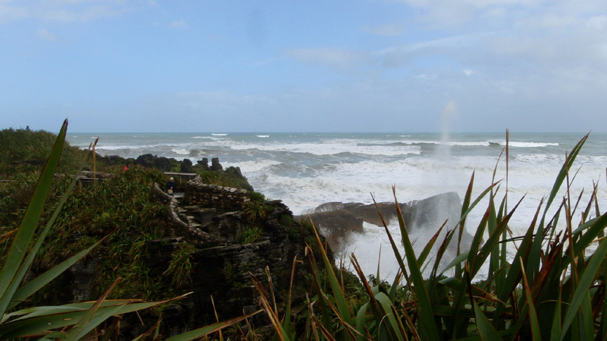
The next day was still cloudy and extremely windy,
but not rainy. We deemed it good enough for touring and set out from
Greymouth heading north along the coastal road.
Picture 2 - Our view of the wild coastal
waters. Needless to say, Don and I were glad we were land touring and
didn't have to brave the high wind and this nasty surf in the boat, or
worse, in the dinghy.
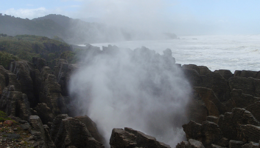
Picture 3 - Punakaiki National Park is billed as
a South Island 'must see', and after having seen it, we agreed.
These are the famous pancake rocks. They consist of limestone
and were turned into 'pancakes' through a layering-weathering process called
stylobedding. Whatever the reason for their formation, they were very
cool to see, particularly in high winds at high tide when the surf was
crashing through the arches and caverns and blow holes formed by the
rocks creating what looked like a steam and water eruption accompanied by
an earth shaking BOOM!
Picture 4 - Thar she blows! One of the many
incredible pancake rock blow holes in action.
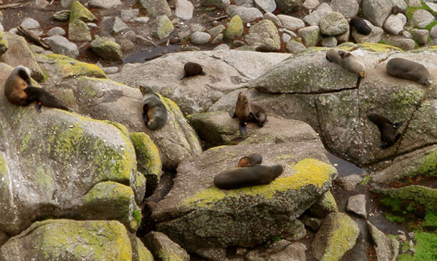
Picture 5 - After we left Punakaiki National Park,
Don drove us further north up the coast to the town of Westport. There,
just a few miles outside the town on rocks jutting out from a short peninsula,
was a fur seal colony. The pups were born in November/December and if
you look closely, you can see that some of them were still
nursing.
Picture 6 - The next day Don got
a vacation from driving and I drove (scary!) Mom and Dad the short
distance to the town of Hokitika south of Greymouth. The main attraction
in Hokitika (aside from the lovely clock tower shown in this picture) is
the jade, or greenstone as it is called in New Zealand. The native Maori
originally discovered the heaps of greenstone in the wide river beds along the
South Island's west coast. Lucky for us, New Zealand greenstone still
exists in the rivers and plenty of Maori as well as transplanted Europeans
still make a living out of carving the stuff. Not sure how much Dad
enjoyed it being the hard core engineer and car man that he is, but Mom and I
did a good job of viewing most of the jade and paua shell (a bit like abalone,
but found only in New Zealand) jewelry Hokitika had to offer. We did
find an ice cream place that ground fresh fruit into the ice cream right before
our eyes using some type of fruit squishing/ice cream mashing contraption, and
that kept all three of us amused for a little while. The town of Hokitika
was buzzing in preparation for their annual Wild Foods Festival scheduled
for the upcoming weekend. We didn't go to the festival, but apparently
it's the place to be for things like huhu grubs, whitebait, barbequed lamb's
tails, testicle stew and the more tame wild pig and venison. Not sure any
of that can be found on the Dad approved food list.
Picture 7 - On the way back to Greymouth, we
decided to take a side trip to Arthur's Pass. Dad, the navigator, found a
short cut from Hokitika to the main road that leads up to Arthur's Pass on the
map. We turned right, off the main coastal road just after crossing one of
those triple-use one lane car/railway bridges and headed for the
mountains. The short cut seemed like a really good idea until the pavement
ran out and we were riding on packed dirt. Then the curves started and the
dirt road narrowed and we started up a foothill. Mom piped up from the
backseat every so often saying exactly what I was thinking, 'Are you sure this
is right? Where are we going? Shouldn't we have hit the main road by
now? Maybe we should turn around?'. Then we saw a cyclist ahead of
us going in the opposite direction. 'Pull over and ask him how far until
we hit the main road.' my navigator instructed. I pulled over and we asked
the cyclist (there were actually two of them on a tandem bicycle - ambitious we
thought), 'How far to the main road?' 'Oh, not too far - just over this
hill and down to the valley.' answered the front half of the tandem cyclist
team. He then asked how far his tandem team had to go before hitting paved
road. We made our best guess in kilometers (generally a foreign language
for us) and then we started up again refreshed with the knowledge that we
were almost there. A long twenty minutes (or was it only an
extra long ten?) of skinny, curvy, hilly dirt road and we emerged onto
the main Arthur's Pass road. Shew! It's still up for discussion
whether our shortcut was really a shortcut or not - something to be
debated during future family dinners perhaps. After another thirty
minutes or so of moderately manageable road, we started going up. Steeply
- about a 17% grade. Wow. The scenery was unbelievable as we wound
our way up and through the mountain pass...but there was nowhere to stop until
we reached a turn-off nearly at the top called Devil's Curve. Comforting
name for a turn-off we thought. A little further up, after we passed under
a landslide protection structure and a waterfall (yup, we drove under
a waterfall) we reached another turn-off where this picture was taken. You
can see the landslide (or slip as the Kiwis call it) protection
structure to the left with what looks like the remains of a landslide on top of
it. To the right is the waterfall, diverted nicely over the road and into
the river. Why drive over a waterfall when you can drive under
it?
More on the rest of our South Island west coast
odyssey later.
Anne
|