Navigating to Palikula Bay
Lochmarin
Tue 6 Oct 2015 22:02
| 15:29.558S 167:14.884E Strong winds were forecast so we headed up the coast just a little to tuck in to a more sheltered spot. It’s a lovely bay but there are some reefs to navigate in order to get in reasonably close to the shore, if you click on [back to index/map] at the top right of this page and use the map to zoom in on the location for this blog you’ll most likely see them. We’ve noticed, since the Caribbean, that our electronic charts have become more and more unreliable. Of course, there’s the odd good area, New Zealand was fine and the Society Islands in French Polynesia were pretty accurate, only 200m offset to the North East, but mostly they are just a crude representation of the area, with a few single point depths marked that bear little resemblance to the actual place. We’ve been doing what all cruisers do: make sure we enter with the sun high and behind us and have someone on the foredeck spotting the reefs and bommies wearing polarised sunglasses. Problem is, the sun doesn’t always shine, there are overcast days, and you may have to come in with the tide, which is not always when the sun’s high. There is a solution. Many cruisers have been using Google Earth to export snap shots of the view you just had on the map (if you did as I told you!) but, rather than just a picture, these come complete with GPS information, GKAP files. These are then imported into a chart viewer (like Open CPN for example, an open source chart plotter). If you plug a USB GPS device into the computer that you’re running the viewer on you can see yourself sailing across the Google satellite view. In exactly, to within a few meters, the right place. This is wonderful, as you can most often see the reefs and bommies really clearly. Our friends Gustaf and Tina on Caminante told us about a different open source program that makes this whole operation much easier. It’s called SASplanet and the advantage with this program is that you can just browse on the satellite images, like looking around Google Earth, but everywhere you look, at the level of detail you look, gets cached on your computer so you have it accessible when you’re away from the internet sailing, i.e. when you need it. The other good thing is if you zoom in using Google Earth and find there’s clouds when they took the image you can swap to Bing's or Nokia’s satellite pictures, choosing the one that’s best. To be useful you have to have thought about where you’re going to go in advance, when you have good internet, of course. The next step is the clever one, and it’s our friends on Adina, Tom and Susie, who put us on to it. You can pop a place marker on the satellite image to show where a reef is or mark a passage through then export it and import it into your regular chart plotter. This is significant because it’s rather hard to be looking on a laptop screen in bright sunshine in the cockpit when you’re trying to navigate reefs, but the chart plotter’s designed to be used in those circumstances. So that’s how we got ourselves into Palikula safely. Here’s a snap of the chart plotter and a screen shot of the SASplanet screen for the same place, showing our track and the three way points we followed to get in. We were anchored in sand in a pool 11m deep. No sign of the reefs on the chart, but they are as clear as daylight-over-your-shoulder-half-way-up-the-mast on SASplanet. 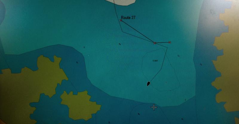 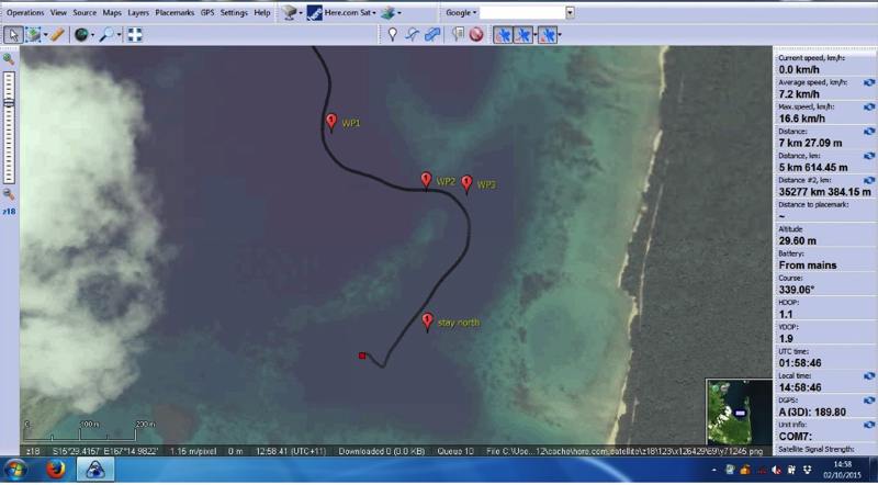 Safely in we were well out of the swell and wind and were able to watch turtles and a dugong in the bay. We went ashore, meeting the local chief, and arranged for Frank’s taxi to take us to town in a couple of days. Frank lives in the village and his taxi takes everyone who works or studies in town there and back each day. The drive to town passed through big open fields with solitary trees in them, for cattle to graze in. If the trees hadn’t had buttress roots or been banyan trees it would have easily passed for an English country scene. Frank was telling us how hard it is for most people to make cash on the Islands. One increasingly used solution is for a family member to go to New Zealand or Australia for seasonal farm work, for up to 8 months at a time. It’s hard on the worker being far from family and friends and hard on the family missing a key member but it’s a real opportunity to make a nest egg, over 5 or 6 years, to start a business with (say, buy a taxi) or build a house with. Sounds good, we thought, but there’s a catch. Frank told us that the Vanuatu agents who employ these transient workers only give the jobs to folk in their villages, or to family members. If you’re outside the circle there’s no way in. We liked our little pool we were anchored in. Scott who we met in Maupihaa (his boat’s registered in Dinosaur, Colorado - how cool is that?) was anchored nearby for company. There was lovely swimming, friendly locals, town was reachable and, if we stuck a phone out on deck, we could sometimes get 4 blobs of ‘E’ on our mobile phones, and even, occasionally, 1 blob of 3G. What more could one want from a well sheltered anchorage? |