Kosterhamnen, Sweden 58:52.926N 11:02.999E
Pelagia
Frans & Sarah Toonen
Sun 9 Jul 2017 17:00
Sunday 9 July 2017. 38nm. 4 engine hours. Passage 8 hours. Light southerly on the nose then SW6, gusting 31 knots. Sea state Moderate to Rough (waves up to 3m) across the mouth of the Oslo fiord. We left Tønsberg marina in very light airs with a forecast of 5 meters per second in the afternoon for the open sea where we were headed. This is about 10 knots (Force 3) and we were doubtful we could even sail so we expected to motor quietly to Sweden lazing around in the sun. Fuel is cheap in Norway so we sought out a fuel pontoon as we motored south from Tønsberg behind Notterøy and Tjøme islands and filled up. As we got further south it became clear the forecast was very wrong as there were strong winds and the sea was building. Nothing Pelagia can’t handle though and we were properly stowed with only cushions and shoes flying around inside. You don’t fill up your fuel and then go in heavy seas as the pitching and rolling forces it out the overflow on deck so we had a bit of leakage. The diesel had no chance to stain the teak though as the dumping waves cleaned it off a treat. Sarah was hiding under the spray hood as usual making a route through the rocks offshore. Frans was asking whether we were ‘clear under the sail’. This means the crew has to look under the headsail for other vessels which the skipper can’t see from his standing at the helm position. We were heeled over so far the sail was in the water so no chance looking under that until the wave action righted us momentarily. Although the waves were quite big and almost side on to us, the wind speed of 25-30 knots kept us charging along around 9knots with limited movement. Making good speed we were out of the rough stuff after 4 hours and inside the shelter of the Koster Islands. Here was another world of tranquil waters and boats everywhere as the west Swedish and east Norwegian yachties enjoyed their favourite holiday islands. The islands are national park and only have tiny marinas. We motored through a very narrow sound and saw smaller yachts rafted 6 deep on tiny pontoons. Just past this tiny marina we anchored in a small bay which had an underwater electric cable coming ashore from the mainland, these are clearly marked on the chart and also with a sign on the shore. We thought we anchored well clear of the cable but a passing Swedish yachtsman thought otherwise. Yachties are very opinionated and have a tendency to shout aggressively, in seems Swedish yachties are no different. This guy was sending the police on to us. We have since been trying to find out what the regulation is for anchoring near a submarine cable but have not been able to find any rules. We played safe and moved on, the bay we anchored in was clearly where all the larger yachts went and for once Pelagia had some big company. Monday was overcast but we took the dingy ashore and walked around South Koster on a trail. We did 16kms/10miles which was virtually around the whole island, clambering over boulders, rocky outcrops and some gravel trails. There are many wild flowers (Sea Holly and Honeysuckle flowering) and a good variety of trees in the forest areas. Allegedly it is a bird paradise but not in July. Very few of the houses and cabins are of any age and the housing development seems uncontrolled as much of it does not seem in keeping with the protected status of the national park. The beaches are narrow and although this is a holiday destination it is lucky the Scandinavian children like spending all day catching crabs as there’s precious little beach to play on. In every marina the children do actually spend all day on the pontoons ‘fishing’, filling buckets with tiny crabs and starfish. The next day they start all over again until they are dragged off to bed. Rocks and scrub - South Koster 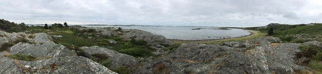 We think most of the housing development is pre-National Park status 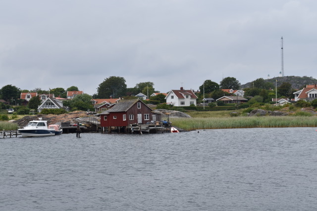 This ferry filled the channel! We had to reverse and wait for him to go alongside.  |