Sørland, Værøy 67:39.628N 012:4 2.090E
Pelagia
Frans & Sarah Toonen
Wed 24 Jun 2015 15:16
| Sunday 21st June 2015. N 2-3 then no wind for an hour then increasing N 4-5. 44.5nm in 9¾hrs, 1.5hrs motoring. A slow sail north west from Bodø in the light airs but we managed to sail most of the way. We stayed as close to the wind as Pelagia sails and this dictated our landfall was the second most southerly inhabited island of the Lofoten’s, Værøy. The island is about 7 miles long and up to a mile wide. It's like a ridge of rocky mountains with a few flat bits. 750 people live here. The guest harbour is one pontoon where, including power and water, the cost is less than £10 a night. Cheapest place we have been in all our 5 summers. It’s amazing to think that this tiny scrap of land has been inhabited for over 3000 years. They have cave paintings to prove it, Viking burial sites and some statues from Nottingham, robbed in 1430 apparently. This harbour is the largest fish producer in the Lofoton’s, cod in the winter, halibut in the summer and herring in the autumn. The cod is dried outside on wooden racks whereupon it is called ‘stockfish’. The name comes from the Dutch word for wooden poles (stok) the fish are hung from. Same routine as they’ve used for centuries, no salt is used - just gut it and hang it. The (dry and cool) climate does the rest. Their market is Italy, Spain and Nigeria where fish is eaten on Fridays for religious reasons. The per capita value of fish exported is over 1 million NOK. On Monday we tried to walk to the area where the bird cliffs are but without proper due diligence our walk can best be described as climbing to 1500’ and spending most of the day in thick freezing cloud before we reached the end of the tarmac at the secure aerial installations at the cliff top. It was handy we had the tarmac to guide us and a ditch at the road edge to sit in for our picnic slightly out of the wind. 15kms of good exercise anyway. Sarah enjoyed the flowers as at least we could see that around our feet the ground is covered in many varieties - even one orchid. Tuesday we did more research and went to the Tourist Office - one lady part time for the 8 week season - for a map. When we reached Nordland and the path deteriorated into scrambling up the scree Sarah turned back and returned by the road (still a respectable 19 kms). Frans pressed on and got in sight of the abandoned village of Mastad where he could see a nice anchorage for settled weather - come by boat tomorrow - so he also turned back and returned over the mountain (33kms so no wonder he’s the one sleeping on the sofa as I write). It’s Wednesday today and from the pontoon we can see that thick low clouds are settled on the ridge and tumbling down into the anchorage so no point moving to anchor in fog. Now we have arrived in our cruising destination we are ready for the weather to hot up. The temperature should be between 8 and 25C at this time of year. Mostly it’s 10 degrees or about 17 when the suns out depending on how strong the wind is. Very variable and it can be all seasons in one day which seems the norm. Confirmation the earth is round! We never did see any more of this ship.  Stockfish 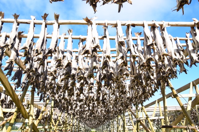 No comment  Wheatear  Sørland  |