17th Day
Ile Jeudi
Bob and Lin Griffiths
Thu 14 Mar 2013 13:24
|
12:56.53N 58:59.34W
Thursday 14 March 2013 at 1200
UTC
Distance Run last 24 hrs 149 nm
Distance Run since start 2063
nm
Distance to go 31 nm This is to a
new waypoint at the south of Barbados. There are a further 22
miles up the west coast to Port St Charles Marina.
I put a request in to Simon about the awkward sea yesterday afternoon and,
although it took him a couple of hours, he managed to produce something more
consistent later. We had a very good wind strength of 16-21 knots for most
of the day and because it was coming from a good angle we carried nearly full
sail and made good speed.
As I write this there are 26 nm to 'South Point' (our original
waypoint was at 'North Point' - the Bajans are creative in their
descriptions of headlands) and another 11 nm to Carlisle Bay. It looks
likely that we will stop in Carlisle Bay as I think it will be dark before we
could reach Port St Charles. It will certainly be after 4pm local
time so Customs and Immigratin will have gone for their flying fish
sandwiches.
Assuming we 'chuck the hook' in Carlisle Bay tonight we will sail up to
Port St Charles tomorrow to check in with Customs and Immigration.
Will update when we know more.
Just checking the knot before re-launching the 'turbine' and 30m of string
for the towed generator:-
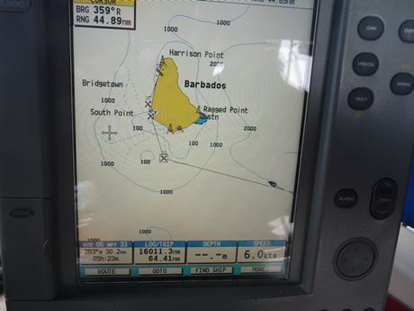
 Destination in sight on the chart plotter. Note the little boat
towards the bottom right of the screen. The waypoint some way south
of land avoids some shallower water which the pilot book advises often has rough
seas. The bottom left box shows 30 nm to the South Point. The next
box to the right shows the total miles logged in the boat (16000 nm).
Underneath this, the figure for the Trip is shown as 64 nm.
It is really 2064 nm - it resets to zero every 999 nm:-
 |