The Route
Ile Jeudi
Bob and Lin Griffiths
Wed 23 Jan 2013 18:23
|
Wednesday 23 January 2013
We hope in the next day or so to leave at last for
the Cape Verde islands. We are both frantically trying to complete all the
things that can only be done just before departure and Lin has been buying the
last of the fresh food provisions. She has washed the fruit and vegetables
on the pontoon before they are brought on board because they sometimes have
cockroach eggs on them which can hatch in the warmer weather we hope to be
moving towards. Cockroaches are not easy to remove from a
boat.
The direct track from Gran Canaria to Barbados
is 2620 nautical miles (nm's are about 10% longer than land miles).
However the route normally taken is the old trade winds route sailed by the
clippers years ago. This follows the prevailing winds around the Atlantic
which come from the north east along the west coast of Africa and
slowly turn to blow from the east as you get near the equator. The old
sailing directios were simply to 'sail south until the butter melts (no fridges
then) and then head west'.
The typical route takes sailing yachts south
west to within 100 or so miles of the Cape Verde islands before they turn
due west. This route is about 150 miles longer than the direct route but
normally quicker. It is the route taken by most yachts in the annual
Atlantic Rally for cruisers. These are fully crewed boats (except in a
handful of cases) and many 'short handed' yachts, with just couples aboard, sailing after the
ARC divert to the Cape Verde islands en route to break the passage into
two. We aim to do it this way as we know it will be tiring sailing with
just the two of us on a long passage and that is when problems can
occur.
It is 834 nm to Mindelo on Sao Vicente which is
towards the north western end of the Cape Verde island group. From there
it is about 2025 nm to the northern tip of Barbados. So the overall trip
becomes about 2860 nm's but instead of one passage of about 20 days, there are
two - one of 6-7 days and the second about 14 days.
So, if we average 5 knots then this passage will
take 7 days shortening to 6 if we average 6 knots. Although we have sailed
together for over 20 years and covered many 000's of miles this will be the
longest single passage we have undertaken so far.
A picture of the route on the chart
plotter:-
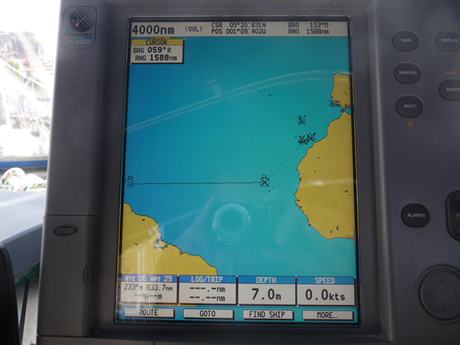 Towards the top right of the screen is the Iberian
peninsular and the crosses mark various waypoints when we were in
Portugal. South west of that is Madeira with another cluster of
waypoints.
Then just off Africa the largest cluster of crosses
are the various waypoints we took around the Canary Islands. The dotted
line leading south west from there is the route to Cape Verde islands and the
horizontal continuous line leads to a waypoint off
Barbados.
|