Another Day
Ile Jeudi
Bob and Lin Griffiths
Thu 26 Jul 2012 11:00
|
34:40.46N 13:00.16W
Thursday 26 July 2012
Distance Run in 24 Hrs, 146 Miles. Total,
249 Miles
Distance to Go 195 Miles
Well we did set sail again and turn off the engine
soon after the last update and continued sailing on into the evening.
We are still learning how to set the wind vane
properly but it does a sterling job when you get it right. It's so good
not to have to use the electronic autopilot which draws a lot of electricity and
makes some noise - right by the ear of the person trying to sleep in the aft
cabin.
The conditions became very pleasant for a while during the day:-
 At 9 in the evening we could see some heavy black
clouds ahead and to the right of us. These usually carry a lot of wind
under them and we hoped it would track north east in the same way that low
pressure areas do. This was not to be and instead it moved east across our
path. We decided to reduce sail dramatically, in case of any squalls, and
put the engine back on and disengage the vane so that we had full control should
anything unusual happen. In the event the wind did increase - nothing
serious - but the sea became very confused again and the dark
cloud brought forward sunset somewhat. We realised this was not just
a brief passing event and decided to run the engine all night with just a couple
of 'handkerchiefs' up for sail to stabilise the motion.
There was very little shipping in the night now we
are away from the shipping lanes. I saw one at 5.30 in the morning and the
AIS told me about another ship 12 miles away a little later but I couldn't see
that the ship itself.
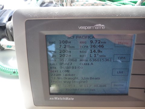
Some of the information shown on the AIS. Sorry about the
reflections. You can see it is the ship SCF PACIFICA. Her
bearing from us is 308 degrees and her range is 9.72 nautical miles from
us. The closest she is predicted to be from us (the closest point of
approach, or CPA) is 7.28 miles. The time this is expected to happen is 36
minutes and 46 seconds away. Her course over the ground (COG) is 202
deg but she is actually heading on a course of 200 deg, so there
are 2 degrees of drift caused by wind and current. Her speed over the
ground (SOG) is 14.9 knots. This is her speed through the water plus or
minus other factors such as wind or current and is broadcast from her GPS
data. Further down the screen you can see her destination is LOME (where's
that?) and she is expecting to be there on 4 August at 1 am.
 Soon after 7 this morning we reached the halfway
distance of 220 Miles. It's always good to see the distance to go on the
chart plotter becoming less than the distance run.
At 5 knots we would average 120 miles a day and we
didn't quite get there by 2pm yesterday. At 2pm today, 48 hours after we
left, we logged 262 miles so the second 24 hour run was much better.
We are still sailing in about 16 knots of
wind and we are both looking forward to a shower once things are a little
quieter. |