Exploring a fat Virgin
|
Our position is 18:30.292N 64:22.201W We managed to leave the anchorage in Anguilla not long after the planned time and without hitting any of the other anchored boats, both lit or unlit. Unfortunately the wind direction meant it was a dead run and initially the wind was quite moderate so we had full sails. In the night the wind got up quite considerably and the wave direction gave a most unpleasant roll to the boat. Sea sickness never seemed far away, but luckily never quite materialised. The good thing was that we sailed fast – the maximum off the waves was 12kn! – so daybreak saw us closing Virgin Gorda. Columbus named the island Virgin Gorda as from a distance it looks like a fat woman lying down. I thought it did but Ted said he couldn’t see it himself. Along the North coast we were just off Necker Island (owned by Richard Branson and virtually surrounded by coral reefs) when Ted looked behind and decided we would soon be hit by a powerful squall, so we quickly put 2 tucks in the main. Needless to say that squall never arrived but later, as we were reaching down the island’s West coast, we were grateful. The approach to Virgin Gorda Yacht Harbour is a channel between reefs and it is quite disconcerting to have breaking water so close, while navigating down the dogleg channel and avoiding ferry boats. Entering the marina was an interesting experience as although our new radio enables us to make contact before entry the instructions were vague and none of the pontoons were labelled. We had been promised someone on the pontoon but the first person to wave at us was only another yachtie deputed to send us in a different direction. When we came alongside the dockmaster ignored our requests as to what to do with the warp I had given him resulting in my having to jump ashore with the bow warp quite quickly. However in spite of all this we were soon tied up safely and being distracted by our neighbour, who wanted to ask about the Duogen before he left, and some fishermen in a berth opposite , who had caught an enormous wahoo. However we were soon heading for customs to clear in. Again I had used e-sea clearance and printed the form, but once again their system couldn’t deal with it so many forms needed to be completed manually, including a 5 part self carbon one, which I couldn’t press hard enough on with my roller ball to penetrate to the bottom and the official only had one biro to lend, which someone else was already using. Eventually we managed to complete everything to their satisfaction and were allowed to leave, check in to the marina, have lunch, and catch up on some sleep. The next day we hired a car and were treated to a nearly new Suzuki Vitara, as the one we’d booked wasn’t available when we got there. It was a pleasure to have something that could make it up the hills without gasping and didn’t mind the rough tracks that passed for minor roads. The island is quite small – only 10 miles long – and with 2 distinct parts with a neck in the middle. There has not really been any effort made to develop many tourist attractions so we went to the North part in the morning and hunted for some sugar plantation ruins. When located the mill had been converted into accommodation for an up-market resort and very little else remained. We also went to look at the North Sound – a popular yachting destination – and discovered that on the land side there was a large area only accessible by boat (or presumably on foot over a long and very hilly track). After lunch on the boat we headed to the South part of the island and its main attraction, The Baths. These are a most unusual formation of large granite boulders forming caves and pools with shafts casting light into them. The adjacent beach has excellent snorkelling so we were hopeful of a swim. We could have gone there in the boat as there are moorings but there is no landing of dinghies on the beach so we thought it would be easier by car than having to swim ashore! There is a small fee to enter the area and the man in the kiosk recommended taking the path to Devils Beach and then following the trail through the boulders to the other beach. This was a good option and the trail through the boulders was both interesting and, at times, slightly challenging. Unfortunately when we emerged on the beach the sea was too rough to make snorkelling or swimming enjoyable and almost immediately it started to rain heavily. Everyone took shelter in the beach bar and when the rain stopped we headed back to the car and went in search of the ruins of a copper mine instead. This proved slightly less difficult to locate than the sugar mill and at least it had an information board and was being restored by an interested preservation group. Apparently until the mid 19C it had been a rich source of copper, which was all shipped to Wales for smelting. This became uneconomic, so the mine was abandoned and the government later sold it to a Cornish company, to recover outstanding taxes. After that it seems unclear what happened as it appears various different minerals were mined on the site before it was finally closed in the 1970s. After that it was back to the boat and a much needed session of replenishing stores at the lively and well-stocked supermarket at the marina, which seemed to be used by all and sundry and not just yachtsmen. That night a heavy session on the families tax returns saw deadlines met at the expense of sleep, but hey – who needs sleep if they can satisfy HMRC! We had been debating where to go next as the forecast for the beginning of the following week was not so good. The next day while we were making up our mind we decided to sail to North Sound and explore the area that could only be reached by boat. In the event, when we got there, the area to the East, which should have offered the most shelter, seemed to be subject to the wind funnelling through and making it rather choppy so we opted for a mooring off a delightful sandy beach on Prickly Pear Island instead and went ashore for the swim we’d kept promising ourselves. There wasn’t a lot to see underwater but the return to the dinghy was enlivened by two Germans nearly starting a fight with a lot of German swearing. We concluded they’d been spending too much time in the beach bar. We’d hoped to get a meal there in the evening, but since our guide was written, it had changed hands and now only did lunches so we had a quick rum cocktail (me) and a beer (Ted) and went back to cook on board, not fancying the exposed dinghy trip to the alternative venue. Monday dawned reasonably benign, so with the warnings from the lady in the Yacht Harbour office that Anegada was too dangerous for just the two of us in the windy conditions we were experiencing, ringing in my ears, we set sail bright and early, aiming to arrive with the sun high enough to enable us to spot the coral heads as we picked our way across the reef that encircles it.
Virgin Gorga (Columbus nust have had a different view) Necker Island (Bransom's personal Virgin)
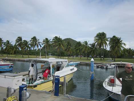
Virgin Gorda Yacht Harbour. Note the big fish haning up. Looking SW Tortola on the horizon
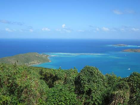
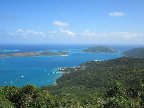
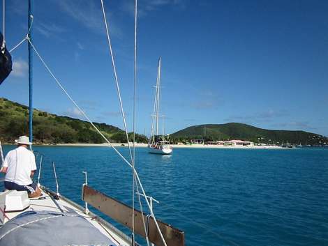
Main entrance to North Sound Looking down on North Sound
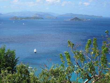
The Dog Islands with Tortola behind them The path down to Devil's Bay
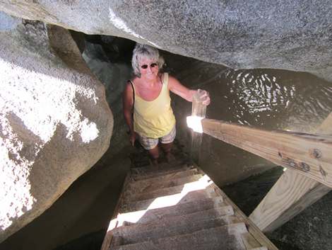
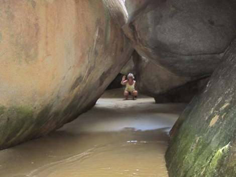
The scramble through the rocks known as the Baths
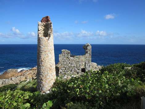
The Copper mine ruin Picking up a mooring of Prickly Pear Island. |