Up a Lazy River
Ambler Isle
V and S
Tue 21 Jun 2011 21:59
32 42N
088 06W
June 21, 2011
We slept til we naturally awoke without the alarm clock
at 5:30am. After so many early mornings, it happens. We noticed that
the river has changed. For the better. The tow boats and even their
barges are freshly painted. The river itself has very few logs and other
debris. Maybe it's been too dry for the logs on shore to be washed
down. Many red and green marker buoy cans are new. Even the day
markers on the trees are new and the mile marker numbers, too. Has the bad
economy given everyone time to spruce things up at bit?
The wildlife is also different this year. Pelicans
followed us up river the first 40 miles. We saw no alligators here.
This is the most populated alligator territory on the Tenn-Tomm
Waterway. We spotted the first ever wild boar grazing onshore. It
was dark brown, and very sleek. A few miles later we saw another boar,
this one a piglet, swimming across the river and climb up on the other
shore. Still later, we saw a couple cows grazing.
Thinking of alligators, the state of South Alabama is
granting 120 alligator hunting licenses this year. 4,000 folks registered
for the prized licences. Although we saw none, they are a huge nuisance
here. They eat family pets, menace small kids, and some places are off
limits for safe swimming. Like in Florida, they have been mismanaged to
the point of becoming dangerous. So, why only 120 licenses?
The wildlife spokesman said they might consider raising the number next
year. Not because they are a problem and need to be reduced, but because
so many folks want to hunt them. Pleas explain the science of wildlife
management in that statement.
M/V Adesso continues to stay with us.
Although we never met personally, they seem to like anchoring with another boat
nearby. Two nights ago we stopped at a poor anchorage across from Bashi
Creek. Smaller boats use the creek to anchor, but we have to drop the hook
across the river. It is very wide there, and a recommended anchorage, but
barge traffic is frequent here. We thought they might reconsider anchoring
by us when they saw our selected spot, but they came ahead and dropped anchor
nearby. Neither of us has our dinghy down, so we couldn't visit. But
after a long day, that was ok. The next day was pretty nice, too.
Hot, but nice. We again ran the boat from the fly bridge, there is a nice
breeze. We had delays at both locks so far. Hope this is not a sign
of things to come. This time Adesso went into Demopolis Yacht
Basin for a much needed rest and we continued on another 10 miles to our
favorite Rattlesnake Creek anchorage. The cicada choir was just
warming up. The wind is so still and the temperatures 98 degrees, so we
have had to run the air conditioning while the generator is on during the
evening. At bedtime, the temps have dropped to 75, and we turn
everything off. Our "elephant ears, " Breeze Boosters are place in the
port lights in our sleeping berth and we find it comfortable. The mornings
are also cool, so we try to do outdoor chores then. We
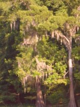
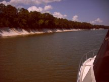
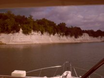
went through a section of White Cliffs lining the shoreline. Sometimes we
think they are manmade, then they seem too magnificent to be. The big
trees draped with Spanish Moss, aka Grandfathers' Beard, are everywhere.
The humidity feeds these "air plants" and makes them thrive.
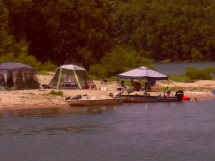
At the Heflin Lock, we met up with 3 power boats
traveling together. They'd anchored near the lock, and by the crack of
noon were raising their anchors and locking through. After we exited the
lock, they called on the VHF to see how far we were going. They were
traveling another 4 miles to the Sumner Point Recreation Area. Yes, I said
4 miles. Their day's log was 6 miles, one lock, 1 hour. We
continued on to Windham Landing Cutoff about 20 miles north. Immediately,
the sky opened up and it rained buckets. Turning on the radar to see, it
was solid green with rain clutter. The windows began to fog, and
visibility was very poor. Adjusting the radar helped, and we also used the
Garmin Chartplotter. We wiped the windows. Soon we could see, but
the rain was torrential. Gust of wind pummeled our starboard side, some as
high as 30 knots!!
We continued on to Windham and entered the creek in 14'
of water at 3:00 pm. Early day for us. We went all the
way around to the exit back on the Tenn-Tomm and found 40' there.
Returning to the shallower water, we anchored in 12', setting on the first
try. It was still raining. We mopped up the sky lounge after the
driving rain. Then sat back to watch the rain and relax.
|