Isla Serranilla
Blue Sky's Voyage
George & Michael
Sun 14 Jun 2009 15:12
|
Hello
Friends
"15:47.8N 79:51.1W"
This blog seems to have turned out as a sailors'
technical special - but we hope you find it interesting.
We had an easy passage south from Grand Cayman - we
managed to get a reasonable wind with plenty of north in it to start with and
relatively flat seas. So after 4 days at sea with 4 hour watches we were well
rested and comfortable.
The sea between Honduras / Nicaragua and Jamaica
looks superficially like a large empty bit of water. But I think you can
see from Google Earth that a lot of it is very shallow. In fact the whole sea is
dotted with shallow banks and channels with strong currents up to 5 knots. So
rather than head directly South from Grand Cayman to Providencia, we took a long
route round to the east of Thunder Knoll and the Rosalind Bank. We encountered
several ships which seemed to be taking the same route, so I guess we chose
correctly.
The Eastern edge of the Rosalind Bank (the large
bank to the NW of Serranilla) is only 7 to 11 metres deep and the seabed rises
very steeply to this edge, causing "a race which has the appearance of breakers"
according to the sailing directions. The pair of channels running SE / NW which
you can see to the W of Rosalind Bank have currents up to 5 knots setting NW.
Our neighbours in Grand Cayman - a 100ft US motor yacht - took the direct route
when heading north from Panama and had a very rough passage through here,
actually damaging the boat's stabilisers.
Anyway, having checked out the area, we also
noticed that there are a few tiny islands on some of the banks. There are some
interesting satellite photos on oceandots.com (no www prefix).
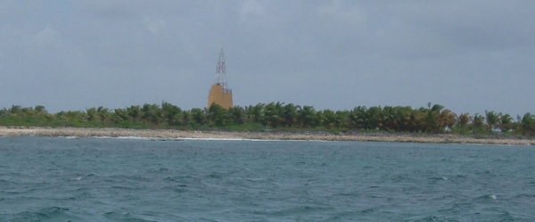
So we decided to have a look at Beacon Cay on
Serranilla Bank - the location for this blog - which is either Colombian or
an outlying US territory according to which website you look at. The sailing
directions describe it as a good anchorage, though that advice is aimed at large
ships rather than little yachts. As we approached, the Colombian troops hailed
us on the radio, though their total lack of English and our total lack of
Spanish (other than 'tres cervezas por favor') made it an unproductive
exchange.
 Sadly the skipper decided that the anchorage which
they wanted us to use was too dangerous for us to stop - a narrow entry through
reef and a shallow anchorage of unknown depth with a lee shore...
The troops were clearly very excited at the
prospect of visitors and positively anguished as we turned away and did not
stop. But since they had been dropped on the island and had no boat to escape, I
guess any visitors were welcome. The Beacon has been painted the colours of
the Colombian flag (only the top being
visible on the photo) and as you can see there are numerous coconut palms, which
were not present on the only (googleearth) photo we could find.
We've now completed our passage to Providencia and
found that their festival starts in 2 days time ! So Blue Sky is dressed overall
and the next blog will report in full.
Best Wishes
George, Michael and Garrison
|