Tangariro Alpine Crossing
Marita3
Mark & Helen Syrett
Sun 14 Dec 2014 09:19
| 39:29.258S 176:02.073E A visit to the Information Centre in Taupo to identify a Freedom site resulted in us booking up to walk the Tangariro Alpine Crossing which according to the Lonely Planet is New Zealands’s must do ‘tramp', as they call them in New Zealand. We booked our shuttle bus which meant that we had to be at Ketetahi car park at the north end of the walk fifteen minutes before the 0815 Backyard Tours shuttle which would take us to the start at Mangatepopo. We found a lovely freedom site at the south end of Lake Taupo all to ourselves except a local fisherman who came and launched his fishing boat on the adjoining slipway. The facilities that are provided for boat people are second to none with tarmac slips, wooden pontoons alongside with cleats, car parking for cars and boat trailers and all this in remote place.  This is the range, with the volcano smouldering, that we were to cross.  We set the alarm for 0630 and sure enough Mark was up five minutes before the alarm was due to go off. It was not until he had made the tea and awoken Helen did she notice that it was only 0530.She was not amused! We decided to drive the twenty minutes to the Ketetahi car park and have breakfast. On arrival we found a mass of cars etc and a lot of people milling around with shuttle buses going to and fro. We parked the Mighty and Mark walked to the top of the lane to talk to the man with the clip board and check in. He was told that because the weather was fair there would probably be in excess of 1,000 people on the mountain! When really busy they can have up 2,000 trampers with 3,000 being recorded on one exceptional day. We were kitted out as required; rucksack, walking boots, warm clothing, waterproofs, first aid kit, hat, suncream, water, food. We also took a walking pole each, the GPS and a torch—just in case!! A twenty minute drive round to the other side of the mountain and we were at Mangatepopo ready for the off but not before our driver had to gather us around and give us a Maori blessing to wish us a safe tramp over the Mountain and to ensure that the spirits would look favourably upon us. and deliver us to the other side.. The literature told us that this was to be a 19 kilometre tramp that would take between 5.25 and 7.5 hours with a summit height of nearly 2,000 metres. At 0900 we were off together with a steady stream of other people, probably with an average age of about 20-25 but a handful of ‘oldies’ to ensure we did not feel out of place. As many had started as early as 0630 the multitude were well spread out. The track had been beautifully “made” which essentially was to keep people on one route in order to prevent damage to the environment. We reached the first station after about an hour an a half and a relatively gentle climb.   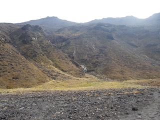 The next hour was considerably harder work as we climbed steeply and over into the volcanic south crater—an awesome sight with a flat circular floor (approx one kilometre diameter) of warm ash with snow on the eastern slope of the crater! All around us the floor was smoking and Helen accelerated across whilst Mark lingered taking photographs! 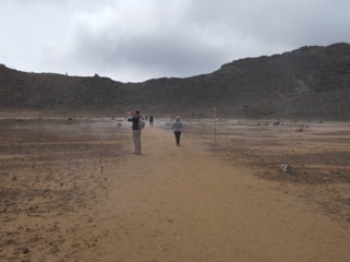  our first selfie in the snow on the edge of the smouldering crater, warm hat and sun hat —very bizarre!  Over the top of the crater at the southern end and then an even more vertical climb which became a scramble over volcanic rock and ash as we reached the summit. By this time cloud had appeared and the stupendous views that we had seen earlier in the day disappeared. The temperature dropped dramatically and those nearby started diving into their rucksacks for more clothing. There was snow around us and the smell of sulphur as the gasses leached from below the surface.  Further away, but too close for comfort, was the Ketetahi volcano that erupted unexpectedly in 2012 having been dormant for over a hundred years——it was belching smoke and certainly did not look dormant despite the sign board at the beginning of the tramp indicating that the volcanic risk was low. Visibility was now about 50 metres so we pushed on or rather slid down the volcanic ash that lay along the ten metre wide shoulder of the mountain summit and into the crater below where the emerald lakes had formed.  However having gone down into the crater we then had to climb back out——legs have a habit of recognising steep climbs approaching and they were reluctant to co-operate! We stopped for lunch for fifteen minutes sheltering from the biting wind behind a large boulder—ham roll, apple, water and a mini Mars bar. Refreshed we went over the top and the weather started to clear and the views to the south were amazing as we looked across to Lake Taupo.  After the first hour the descent became relatively straight forward but long and we had to cross the point where the larvae from the 2012 eruption had flowed.  We reached the Ketetahi car park in the sun at 1515 —a six hour tramp! Lots of people lying around waiting for their transport back to their hostels, campsites etc. The trampers came from a multitude of countries; Germany featured heavily intermingled with some Dutch, Chinese, Japanese and Kiwis but we did not meet any Brits. It was a great tramp and well worthwhile even if the leg muscles revolted at times—thank goodness for Helen Tite, pilates and keeping the core engaged! After a brew up we set off towards Napier, the art deco town of NZ. We are told that it was not possible on one of the previous blogs to read the Sotheby’s estate agents sign. It read: "Proudly presented by Renee Vorstman, artfully uniting extraordinary homes with extraordinary lives” |