Montenegro along the coast
|
Montenegro like all the former Yugoslavia countries has a
very complex history based on being invaded and occupied for many centuries.
Illyrians (Indo-European tribes), Greeks and Romans came. The Romans occupied
most of the Dalmatia coast in order to deal with the Illyrian pirates. When
the Roman Empire split into the Empires of Rome and Byzantium (Constantinople
– Istanbul) this lead to the split of the Eastern Orthodox and Roman
Catholic churches right in the future Montenegro area. With the disintegration of the Roman Empire in the fifth
century and the Age of Migration series of invasions from Central Europe and
Asia occurred. The Goths (Germans), Huns (Attila who died in 453), Avars
(Turkish tribe), and Slavs (7th century) settled here. The Slavs
were comprised of three separate groups; The Slovenes who settled in the north,
Croats in the west and Serbs in the south. Due to the mountainous country the
groups grew apart and spoke different dialects. Still under Byzantine rule they sent two Thessaloniki
missionaries, Cyril and Methodius with the task to create an alphabet for the
Slav language. St. Clement, a disciple of Cyril, devised a simplified version
known as Cyrillic. A Slav state was formed under Jovan Vladimir and his
successor, nephew Stefan Vojislav, was a great battle in 1042 that broke them
away from Byzantine rule. In the 12th century a dominant family
emerged and the House of Nemanjic ruled for two centuries. They also
established and independent Serbian Orthodox church in 1219, however coastal
towns such as Kotor and Bar were still Catholic. Over time the Serbian empire
declined, especially under Uros V (1355-71), Uros the Weak. The Ottoman Empire was growing at the time and began to
encroach into Bulgaria and Kosovo. The beginnings of Montenegro (Crna Gora)
was formed with a principality in Cetinje in 1482. During the 16th and 17th centuries the
local clans gained strength as the mountainous country provided a degree of
protection from the Ottoman rule. Danilo Petrovic gain control and created a
hereditary theocracy that united the Montenegro tribes against the Turkish
rule. In 1715 he paid a visit to Peter the Great in Russia and gained an
alliance with Orthodox Russians against the Ottomans. The connection with
Russia continued into 1785 under Petar I Petrovic Njegos who was well educated,
spoke Italian, French, German and Russian. Much of the creation of the state of Montenegro came from
Petar II Petrovic Njegos who ruled during 1830 to 1851. Six foot eight inches
tall, crack shot, Montenegros most famous poet, brought the first printing
press to the country from Russia and created governmental bodies, schools and
libraries. Post WWI Yugoslavia was created which is a recent history I
will not delve into except that Tito took control post WWI, split with Russia
and Yugoslavia became a bit more liberal and tourism increased in Montenegro.
Following Tito’s death on 4 May 1980 national sentiment and ethnic
tensions rose. Milosevic came into power, fighting began but Montenegro was
not heavily involved. It did have a large influx of refugees from Kosovo when
the NATO bombing began. In September 2006 Montenegro became an independent country.
It uses the Euro a currency and is working toward entry into the EU. Enough condensed history. What did we see. Our visit was
generally confined to the coast areas but we did go inland for a couple of day
trips. It is interesting in those trips we got a flavor of the people and the
country. Most readers will not remember but Yugoslavia was devastated by a
large earthquake in 1979. With much assistance they rebuilt many of the old
cities, in fact over-restored in some areas. The old towns (Stari Grad)of
Kotor and Budva are fully restored and have kept the city plan intact. Many local and tour books state that the roads are full of
potholes and poor. I found this is not the case in comparison to crumbling
roads in rural New England, potholes in NYC or the sliding away roads along the
California coast after heavy winter rains. I did not find of hit a pothole
driving around. There is a relatively high accident fatality rate but that
seems more related to refusal to wear seat belts and pass cars with a bit of
the Italian sense of urgency. I did find it curious that nearly all motor bike
and scooter riders wore helmets but the girlfriend hanging on was not. I was
told if they become more serious, then a helmet usually appears! We found the Garmin type GPS to be essentially useless. There
are only a few roads and the chips do not have the data current. Nearly all
the time it thought we were driving across open fields and then just gave up
and told us to drive to the town with no directions provided. It calculated
the distance to the town as the crow flies but ignored the rivers, mountains
and valleys. We were only 9 kilometers from Kotor according to Garmin but we
were 30 kilometers by road. Not an issue, there are enough road signs to get
you everywhere. Prices? Haircut and wash 8 Euros. Rental car 50 per day.
Meals ½ to 1/3 the cost of Italy or Switzerland. VAT 17%. Fuel 1.20 Euro per
liter. Taxis are higher but inline with the rest of Europe. And yes there are
still Yugo cars driving around. But most of the cars are VWs, Skodas, Fiats, and
Japanese city cars. Weather? First days were 35 degrees C and no wind. Then
rain like Houston rain. Made the boat shiny clean! Gusts of wind, enough to
part a mooring line, lucky I always want two line at the bow.
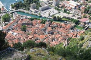
Old Town (Stari Grad) Kotor taken from the defensive wall
above.
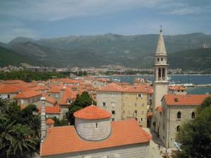
Old Town Budva taken from the Citadel. Looking into the
harbor with all the tourist shops and beaches in the background. Not a quiet
place at all.
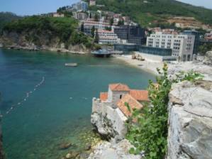
Another Budva beach shot. Clear water but stoney beaches.
Herceg Novi, town near Gulf of Kotor entrance. Mostly
vacation place with restaurants and hotels.
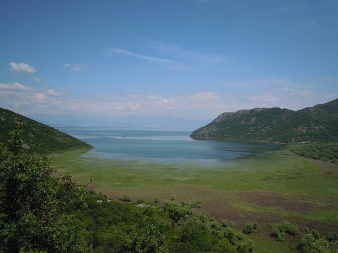
Lake Skadar, largest lake in Balkans which is shared with
Albania. Location of picture is 42013’.8N 19006’.2E
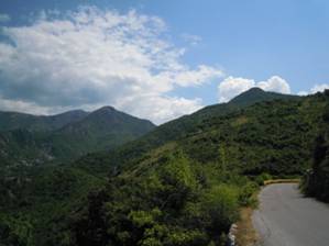
Mountains and roads near lake Skadar. Looks like California
road or even a Swiss road. By the way it is only 1.5 cars wide.
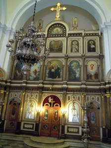
Orthodox church in Kotor
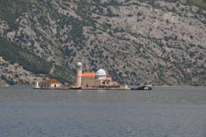
Chapel on an island in Perast in Gulf of Kotor. Annual
event is to carry rocks out to the island by boat to reinact its creation.
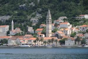
Town of Perast from the water. |