Cassini blog # 127 - Twinkle, Twinkle Little Star
Cassini's blog
Simon and Sally, Nigel and Catherine
Sun 12 May 2024 21:13
|
With the arrival of GPS (Global Positioning System) you
can tell where you are within 10 metres anytime of the day or night. With a
Smartphone in your pocket you can navigate around the globe with ease, both on
land and sea. On Cassini we have a GPS receiver linked to our chart plotter
which tells us where we are 24/7 and we can easily plot a route and get our
auto-pilot to follow it. Navigation made easy!
But what if GPS was not available? GPS is an American
government owned system and is also used by a
large number of military organisations around the world. There are alternatives
such as Elon Musk's Starlink, but this requires a large set up cost and monthly
subscription. Europe is developing its own system, Galileo but it is not yet
widely available. In time of conflict GPS could easily be interrupted or removed
altogether.
For thousands of years mariners have been using the
stars and sun to find their way across oceans. The Vikings had a very basic
sextant and could work out their latitude by looking at the sun.
Over the centuries the art and science has been
refined and as better sextants and chronometers became available navigating
by the sun and stars became more and more accurate. The process is complicated
and relies on spherical trigonometry, which I will not attempt to explain here!
But a number of large publications are required and it is very data
driven. Their is huge potential for error in every aspect and it can be
very time consuming. Just taking an accurate sight on a rolling platform is a
challenge in itself. Preparing for, taking and working out a set of evening
stars can be hours of work. So with GPS at your fingertips why would you bother?
Thankfully modern technology has come to the rescue
and there are now apps to take all the hard work out of it.
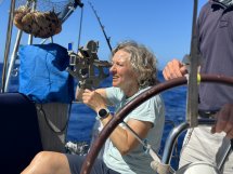
The crew on Cassini were keen to try their hand at this
ancient skill and so I got out my trusty sextant and away we went. This week,
after some basic instruction on how to use the sextant, we started with a set of
sun sights. We took a sun sight mid morning, followed by a meridian passage
sight (when the sun was at its highest in the sky). This gives you a very
accurate latitude position. This was followed by a sun sight in the afternoon
and we then had an accurate three point fix which was within a few miles of our
real position - more than adequate in the middle of an ocean.
We then did a set of evening stars with names like
Arcturus, Betelgeuse and Sirius. With the assistance of Coelman's
Celestial Navigator app we managed to find our position again within a few
miles. Apart from a sense of satisfaction, should our GPS receiver fail then we
should still be able to find the Azores!
Nigel the Navigator
|