Heavenly Bodies
Catacaos
Graham Shaw
Fri 16 Jan 2009 21:03
For the first time in three days we have seen the sun but the 'wind' column
in the log book still has far to many NE7s and NE8s in it for my liking. We
seem to consistently have 10 more knots of wind than forecast. Progress is
still good and it looks like tomorrow will be our 'Hump Day' (HD normally
refers to Wednesday being the hump of the working week as its downhill from
there, but for us it will be the day we pass the halfway mark between Cape
Verdes and Barbados).
Still no meatballs but Lorraine is doing a lasagne tonight. Its not the same
but beter than my tuna (tinned) suprise from last night.
After my previous mention of using Graham's sextant I am sure lots of you
are wondering how on earth can you determine your position using
observations of heavenly bodies like the sun, stars or the moon. Well, for
all of you who fancy a crash course in celestial navigation here goes....
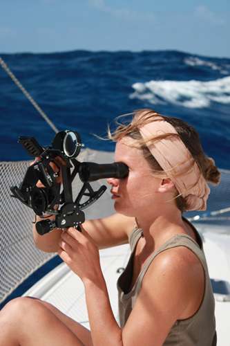
A sextant (see attached picture of Pauline using the sextant for a sun sight
today) is used to measure the angle between two objects, when used for
celestial navigation it usually measures the angle between the horizon and
the sun, planet, moon or star. As an analogy, imagine you are stood in the
street and can see a street light ahead of you. If you measure the angle
between the bottom of the street light and the top you can use a simple bit
of trigonometry (if you know the height of the light) to calculate how far
away from the street light you are. The bigger the angle, the closer you are
to it and vice versa. At this point you just know how far aware from the
bottom of the light you are, you don't know in what direction, so you are
anywhere on a circle that has the bottom of the street lamp as its centre.
The radius being the figure calculate using trigonometry.
With navigation it is very similar. When we take a sight (nautical jargon
for using the sextant to make an observation) we can use some simple
geometry (better explained with an orange, pen and paper rather than just
words) to determine how far away from the Geographic Position (GP) of the
object we are. The GP of an object is the point on the earths surface that
is directly below the object (imagine a bit of string between the centre of
the earth and that of the sun, it only goes through a single point on the
Earths surface). This GP can be found using a set of table that are
published for each year, you look up the object for that particular hour,
minute and second and the exact latitude (declination) and longitude
(Greenwhich Hour Angle) can be found. The GP of the sun moves north and
south with the seasons and it moves west completing 360 degrees every day.
So if we know how far away from a particular point we are, we know we are
somewhere on the circle with the GP as its centre and a radius calculated
using the nifty geometry we used earlier. As these circles are generally
pretty large, say we are in the north atlantic but the GP of the sun is
somewhere over Africa, it would be impractical and inaccurate to have chart
big enough to allow us to draw this circle, so we choose an 'assumed
position' and calculate (using spherical trigonometry, log tables or sight
reduction tables) what the exact angle between the horizon and the sun would
be if we were actually at our assumed position and then compare it to the
angle we got on our sextant. If the angle on the sextant is bigger than the
one calculated for the assumed position then we are closer to the GP of the
object (think of the street light again) and vice versa. If the difference
is 1 degree, then the distance is 60 nautical miles. As these circles are so
big we can assume they are a straight line when we plot them on a sensibly
scaled chart, they are drawn perpendicular to the direction of the object
observed (again this direction can be determined by calculation or tables).
Add in a few corrections for height of eye (if you take the sight from the
top of a mast you will get a larger angle than from sea-level),
semi-diameter (we measure to the bottom of the sun rather than its centre)
and refraction (the light from an object bends as it passes through the
progressively thicker air so it appears higher than it actually is) and
bob's your mother's brother!
So we now have a 'position line' on our chart and we are anywhere along that
line. If we want to know where along that line with need to cross it with
another position line which we can achieve by several means such as
'shooting' multiple stars and planets, running fixes or maybe using the
moon.
When the sun is due south it is at its highest point in the sky and so we
can relieve ourselves of all the fancy calculations and just use a bit of
addition and subtraction to calculate our latitude. This has the added
advantage of only needing to know GMT to the nearest few minutes rather than
to the second for all other observations.
I'm sure all this sounds very simple, but the hard part is getting an
accurate reading on the sextant itself. You need to judge when the boat is
at the crest of a wave and also ensure the sextant is vertical by swinging
the sextant so the image sways like a pendulum. When done well, your
position lines should have an accuracy of under a mile, on a heaving boat,
in a howling gale, with only glimpses of the sun through broken cloud, then
five miles may be more likely.
Gareth.
P.S Pauline just wants to let everyone know that she had 40kts of true wind on her watch!