North to Cape York
CARANGO AMEL 54 #035
PETER and VICKY FORBES
Thu 18 Aug 2016 05:19
First the planning. 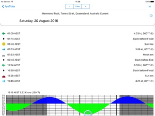 We go to our tidal ‘App’ Aye Tides and check to flows relative to the high tide near the Cape - it is an awesome Cape with a savage reputation for wind and tides as the mighty Pacific Ocean meets the immovable continents of Australia and Asia and has to force the water in between. Quite different from the waters pushing between Hurst Castle and the Isle of Wight! well similar bit on a larger scale. This shows that the Westerly flow [which is what we want] starts at the slack tide on 20th August at 0945 AEST so we must be there at about 0900 so we catch the turn to the maximum Westerly flows at 13.24 AEST. So get sailing and ‘make it accurate’!!! We go to our tidal ‘App’ Aye Tides and check to flows relative to the high tide near the Cape - it is an awesome Cape with a savage reputation for wind and tides as the mighty Pacific Ocean meets the immovable continents of Australia and Asia and has to force the water in between. Quite different from the waters pushing between Hurst Castle and the Isle of Wight! well similar bit on a larger scale. This shows that the Westerly flow [which is what we want] starts at the slack tide on 20th August at 0945 AEST so we must be there at about 0900 so we catch the turn to the maximum Westerly flows at 13.24 AEST. So get sailing and ‘make it accurate’!!!We are, in this wind, sailing almost all the time at 7 - 10 knots - one needs to be permanently alert on watch as the reefs frequently under water sometimes with marker poles and sometimes not crop up quite quickly - a trip below to make tea can put one uncomfortably close to such a reef. The Islands seem for the most part to be low coral islands with no trees or high projections.  First a ‘nespresso’ - V and William Ansell in the relax naughty corner. First a ‘nespresso’ - V and William Ansell in the relax naughty corner.Up this rather desolate coastline there are a number of shipping channels - fine but it means quite a lot of huge nay Gigantic traffic mainly, it seemed to us, coming Southbound straight at us. One cannot veer right or left or one is on a reef and the passage is often quite narrow. We choose the inland passage finding thinking that the major cargo ships would use the ‘big boys’ channel - straighter and further out to sea - but no as we have a wind gusting at up to 35 knots and often a steady 27-30 kts - they want the inland channel too.  It is difficult to show effectively by photograph how close and how large these things are. It is difficult to show effectively by photograph how close and how large these things are.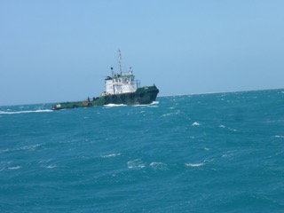  This tug has a 150m tow of a horrendous looking barge which in turn is towing a parachute on a long line to keep it straight and I guess to slow it down. This tug has a 150m tow of a horrendous looking barge which in turn is towing a parachute on a long line to keep it straight and I guess to slow it down. |