Escape Plan

Peregrina's Journey
Peter and Margie Benziger
Mon 24 Sep 2012 21:53
06:06.4N 118:00.6E
ESCAPE PLAN
Recently,
Peregrina was anchored at a small Island called Libarran - off the North East
coast of Borneo.
In Borneo,
the nautical charts we use are good on a large scale; provide some guidance on
a mid-scale and are quite dangerous to use on a small scale….such as when
anchoring off an island. Nautical charts
here come from a large variety of sources and some information may be 40+ years
old. Often the information was gathered
without accurate GPS latitude & longitude figures. And, in many cases, the bottom has changed
dramatically due to wind, waves, storms and silting so caution must be taken
very seriously.
The best way to anchor is to consider
a multitude of data before you make the decision as to where to “put the hook
down.” Aboard Peregrina, we try to watch water color, waves, the depth sounder,
the charts, the tidal range and, most important, our basic intuition. We try to get close to shore but still
maintain least 15+ feet under the keel and a good distance from any visible reef
or coral heads. The last thing we want
to do is damage our happy home by running aground!
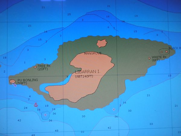
You can see that Libarron has a very
large green reef around it with the exception of the southwest corner. The water there was relatively shallow, but
not too shallow, and we figured it offered the best opportunity to get close
enough to dinghy into shore.

We approached
the island slowly but, all of a sudden, our depth meter indicated that we had
only 6 feet under the keel! We turned to
port and headed back out. When the meter registered 15 feet under the keel,
Margie dropped the anchor. We put out 60
feet of anchor rode (chain) and then put Hercules, our mighty Yanmar diesel
engine into reverse to “set the anchor.”
Once we were satisfied that the anchor held, we put out another 40 feet
of chain for a total of 100 feet. FYI - We use a huge 115 lb Bruce Anchor which
has never dragged yet. Thank you, oh
Anchor God in the Sky!
After
anchoring, we usually wait about an hour before leaving the boat just to be
sure that the anchor is holding and that, as the boat swings to the wind, she
stays in deep water. The lowest depth recorded under the keel during our swing
was 11.5 feet. We anticipated another 4.5 feet in tidal drop at low tide which
should still have given us 7 feet of water under the keel at the shallowest
point. That’s lower than we normally like but we didn’t have a lot of options
so we kept working down our anchoring “checklist.”
Next, we launched the dinghy and, as
is our practice, we made a circle around Peregrina at what we anticipated to be
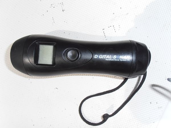
the furthest length she could swing at anchor. Normally, we do this with our
hand held digital depth sounder – one of my all-time favorite Christmas
presents from Margie. (Yes, I know I’m easy
to please!)

Unfortunately, that depth sounder had
a “digital malfunction” a few weeks ago so we had to try to gauge the depth
visually. This was very difficult as the water was not clear enough to see the
bottom well but we couldn’t see any obvious problems. Again, this was not optimum comfort level
anchoring but we could live with it.
Finally, noting the afternoon clouds
were building into dark, high cumulus thunderheads, we discussed our “Escape
Plan” which consists of preparing everything on the boat for a rapid night-time
departure if it becomes necessary. The
most important element of our plan is establishing a magnetic compass bearing
that we can follow to safety. The reason for using a magnetic compass bearing
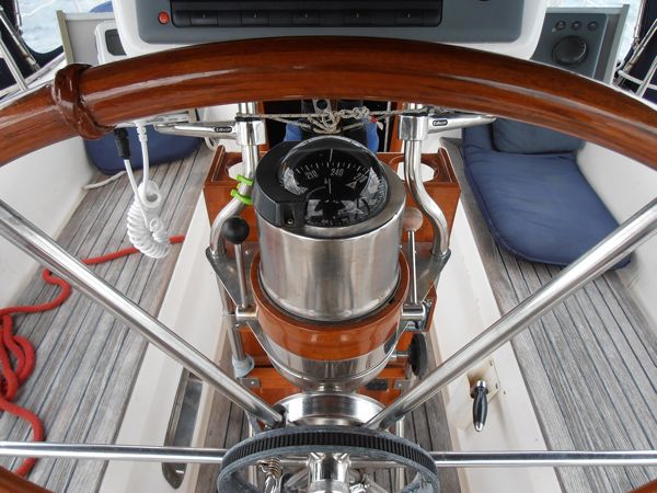
is that this information is available immediately. We have a large lighted compass right in front
of the helmsman at the wheel. We determined that our escape course was 235
degrees, which on a 360 degree scale would be southwest and we both commit that
to memory.

Modern technology is wonderful and we
have installed all the best electronic equipment possible on Peregrina but, if
we wanted to use the Raymarine Chart Plotter to follow our track out of this
anchorage or establish a “True” GPS Bearing for our escape, we have to turn on
all our navigation instruments; wait several minutes for them to warm up; wait some
more for the GPS to acquire sufficient satellites and then cycle through the
various start-up screens. Using a “Magnetic” bearing from an old-fashioned compass
is much less complicated - a “no-brainer” you might say, but that’s what you
need in an emergency.
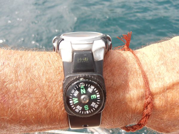
I even keep a little magnetic compass
on my watch band! I have used it on the
boat when I’m down below to check the wind direction; when I’m navigating on
dinghy trips and even when hiking in the jungle. (We’re talking deepest, darkest Borneo
here!!!)

If “Magnetic” was good enough for
Magellan …it is good enough for me!
So, back to
Libarron and the storm which started with light rain about midnight. (Why is it
ALWAYS midnight?) In our berth, we were
awakened as the rain increased as well as the wind. Next to our bed, I keep a
portable Garmin GPS – another technological marvel. I turned it on and entered a waypoint for
Peregrina’s anchor position and set up an electronic “anchor watch” which would
alert me with a buzzer if the boat dragged anchor. Then, back to a fitful sleep.
The wind
increased to about 30+ knots and the seas built up sufficiently for Peregrina
to begin hobby- horsing up and down. About 2am, we felt her strike the bottom.
When that happens, you wake up with the speed of a cannon shot and usually
pause, in disbelief, for a few seconds while asking yourself if you were
dreaming? A couple more jolts and I knew this was for real! I checked the
Garmin and saw that, while we had not dragged anchor, we were being blown in a
new direction - to the east and parallel to the shore. Apparently, there was much
shallower water in this direction that was not on the chart and that we had
missed in our dinghy trip around the boat due to the poor visibility.
The thuds
were getting frequent and the tide was still going down. We had to act fast!
One option is to just take in some anchor chain and try to pull the boat toward
the anchor, into deeper water, without using the engine. This is often the best
first choice. The danger is that, if you take in too much chain, you may
actually pull the anchor out which would mean a quick, potentially hull-crunching
trip onto the reef!
Instead, we decided
to turn on Hercules and motor back towards our anchor. We would try to get it off the bottom before
the wind blew us either backwards onto the reef or caught the bow and turned us
to starboard where we would run aground as we drifted towards the island. Margie
made her way to the foredeck to pull the anchor up. I told her to just keep the winch working and
not to stop until the anchor broke free and then we would charge out on our
compass bearing of 235 degrees.
It was raining
heavily and the wind was still over 30 knots and the seas were pounding on
Peregrina’s bow. I turned on the
decklights so that I could see Margie clearly but that meant that I lost night
vision to see any landmarks outside the boat. We were bumping the bottom
frequently at this point and I tried to use bursts of engine speed each time
Peregrina lifted free of the bottom. Slowly, we moved towards the anchor. When
it broke free of the bottom, the wind caught Peregrina’s bow and blew us towards
shore. I muscled the wheel towards 235 degree magnetic and when Margie gave me
the “thumbs up” signal which meant she could see the anchor, I pushed the
throttle forward and headed out on our Escape Plan route.
Once we got
into 30 feet of water, we dropped the hook again to wait for daylight. We set
the anchor and it held firm. Crawling
back into bed, I reset the handheld GPS with a new waypoint; checked that the
anchor dragging function was on and closed my eyes for some sleep chuckling as
I remembered Eric Stone’s famous sailing ballad, “If You Ain’t Been Aground,
You Ain’t Been Around!”