16:43.54S
179:43.78E
Friday
2nd November 2012 – Savusavu and Eastward with Dodgy Charts to a
Beautiful Anchorage
Later in the
morning of Friday 19th October the customs/immigration and health
officers boarded Arnamentia in Savusavu.
All went well, our having submitted the required entry forms on line
before departing Tonga. We had also prepared as much as possible
of the Inward Report and printed out two copies whilst we were in
Tonga. As ever, much of the information
required had already been submitted but this form wanted to know the size and
make of all our engines (inboard and outboard), the make of our dinghies, radar
and radios. It’s all stuff we’ll
have to regurgitate on an identical form for arrival in New
Zealand.
We had to meet the Bio-security man ashore the next day but that was
entirely painless apart from the fact that we had to pay him around 90 Fijian
dollars (about 2.75 Fijian dollars to the pound sterling) for clearance. Then we needed to get a taxi to the
hospital a few miles out of town to cough up another 172 Fijian dollars or so
for health inspections/services.
I’m sure it makes sense to someone and we don’t begrudge our
contribution.
As ever we dallied
longer than intended in Savusavu.
The town is small and engaging and there are plenty of cruising boats
about. We booked in to the Copra
Shed Marina and found them very helpful and the whole setup well organised. Carol undertook an advanced open water
diving course to qualify her for diving to 30m. Although she has been taken on many
dives to below 18 m – her previously qualified depth – at least should she
require medical treatment her insurance will now cover her. She had to undertake 5 dives and a
knowledge review on a variety of subjects.
One of the dives was a navigation one and as a long time orienteer she
was pleased that she didn’t get lost.
The diving in Fiji is world class and is
particularly renowned for soft coral.
These are very beautiful and harbour such wonderfully named creatures as
nudibranches (soft-bodied,
marine gastropod
molluscs)
rock mover wrasse and clown trigger fish. Photos below care of Google
Images.
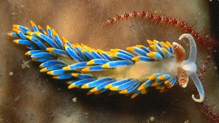
Nudibranch – actual size about 3 cm
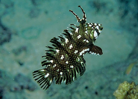
Rock Mover Wrasse – he jumps around like a lamb gambolling in a
field!

Clown Triggerfish
We took a
taxi for a day to see some of Vanua Levu island
– it was cheaper, at 120 Fijian dollars, than hiring a car and it was more
productive. Our taxi driver was
most informative and charming. We
saw a great deal of stunning countryside interspersed with somewhat ramshackle
villages and did the, by now obligatory, wander through a forest to a
waterfall. There are several high
class resorts close to the coast at various points offering chalet style
accommodation in beautiful surroundings.
We visited a couple and it seems that all are struggling to attract
punters in the current financial climate.
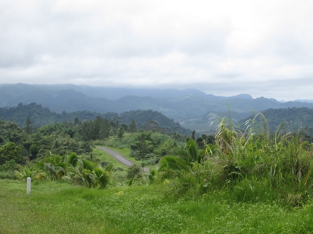
Vanau Levi Highlands looking towards Savusavu Bay
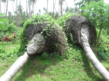
Local carvings adorning a resort garden – not dissimilar to those
sculptures found at Helligan
One day we
were both down below and heard what we thought was a very noisy dinghy motoring
past. Popping up top we were amazed
to find a small seaplane motoring by on its way to the Copra Shed where it
picked up a mooring! As you
do.
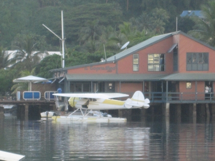
Well now – there’s a smart looking dinghy. Outside the Copra Shed Marina
buildings
The politics
of Fiji are, as we know, pretty
different. There is a military
government, the population is about half native Fijian (they own most of the
land under traditional arrangements and apparently cannot sell it) and half
Indian (descendants of the indentured workers on the cane farms of colonial days
who now do most of the productive work either in farming cane – leasing the
necessary land - or in business) and there is a debate going on (fuelled by
ministers of the Wesleyan Church) about making Fiji a Christian state despite
the fact that about half the population is Hindu. Add into that mix a growing Chinese
presence in delivering various infrastructure projects and obtaining fishing and
mineral mining rights – not to mention, perhaps, a bit of an understanding about
how voting in the UN is to work.
However, these facts seem to have little bearing on day-to-day lives of
most people. They are almost
universally relaxed and extraordinarily friendly. Life’s too short and politics is
something other people do. Keep calm and carry
on.
The charting
in Fijian waters is tricky stuff.
You do come across British Admiralty based paper charts which claim to be
WGS84 compatible. Hooray – so the
GPS will work. But, just take a
look at the source diagram on the chart.
You may be surprised to note that, WGS84 compatible or not, the latest
survey in some areas of the chart was conducted by someone like Lieut Slowpoke
RN aboard the schooner HMS Misguided in about 1830 using a sextant, dodgy
chronometer and leadline. In an
average year, one gathers, yotties hereabouts manage to chalk up 60 to 80
serious groundings on the reefs requiring urgent repair and 6 or 8 total
losses. This year has been good so
far – only 2 total losses.
There is a
most engaging and helpful Kiwi-born cove in Savusavu called Curly. He lives on a houseboat in the creek and
has spent longer than he cares to recall doing so. He specializes in producing detailed
sailing instructions and safe waypoints to get you through the reefs into
various anchorages and around the islands generally. In addition you’ll get all sorts of
advice on where to dive, snorkel and wander and with whom. This is solid gold and he charges very
little for his detailed advice and his e-mailed
notes.
We decided
to leave on the morning of Tuesday 30th October, armed with Curly’s
notes and waypoints, for a delightful anchorage called Fawn Harbour, some 35 miles away and to the
east of Savusavu. To windward,
obviously, and so Mr Perkins was going to be called upon to get us there. Gentlemen don’t beat to weather and
neither do we if we can help it. We
needed to leave by about 1000 to get to the anchorage, through a pretty twisty
passage through the reef at its entrance, by 1600 latest. Otherwise, the light was not going to be
good enough to make pilotage through the reef safe. Knowing assumption to be the mother of
all the best foul-ups, just before we dropped our mooring lines Jon zoomed in on
the anchorage in Fawn Harbour on the chart plotter. He discovered to his horror that, using
the Navionics digital charting used by it, at any resolution better than about
1:500,000, all detail in the area around Fawn Harbour disappeared. The waypoints remained but the only
charting information was in the form of a Mickey Mouse block diagram that bore
no relation to reality. It might as
well have been a blank screen. Hang
on – 1:500,000 (five hundred
thousand)? That’s
1/10th the scale of a standard 1:50,000 Ordnance Survey Landranger
map. The bog standard UK A3-sized
floppy road atlas you can buy at most UK petrol stations is typically at
about 1:300,000 – so approaching twice the scale the chart plotter was
offering. And, you think we’d going
reef-hopping using that? I think
not. Anyway, at 1:500,000 you
couldn’t make out anything of Fawn Harbour. The whole thing was obliterated by about
half a dozen waypoint symbols.
Urgent consultations with Curly followed. He very kindly lent us a 1:150,000 scale
paper chart and Jon dived off to the chandlery to buy a couple of 1:50,000 scale
paper charts to cover Fawn Harbour and some others, further east,
that we intended to visit. The
1:50,000 charts are definitely not WGS84 compatible and you have to move any GPS
derived WGS84 position about 200m (0.11 minutes) northwards and 500m (0.23
minutes) eastwards to make any sense of it. But, that’s more than do-able. We did toy with the idea of using one of
our Garmin handheld GPS sets and telling it to use the Fijian datum but, of
course, despite the fact that it recognises a hundred or more data it hasn’t
heard of that one. We also fired up
the laptop with its C-Map and Open CPN charting. This was a great deal more helpful and
zoomed in to whatever resolution made sense – its ‘Over-Zoom’ notification
telling you that your zooming in doesn’t mean that you are getting any more
detailed information than you got at the last resolution. You’ve got the same stuff but at a
magnification the half blind can read. That’s OK. Of course, the laptop screen isn’t great
for viewing in strong sunlight.
However, in the shade of the bimini it was just about readable by Jon at
the helm. So, the toolbox of choice
became waypoints on an otherwise blank screen on the chart plotter, a laptop
plus GPS for squinting at on top of the cockpit cushions and a paper chart that
didn’t understand GPS. Then there
was the really important stuff; polarized sunglasses, open eyes and a lot of
concentration, care and attention.
By the time
we’d resolved all that it was too late to leave Savusavu that day and anyway it
was very overcast. Not good for
reef-hopping. So we delayed
departure until Wednesday 31st.
That dawned clear and bright.
We left in good time and got to Fawn Harbour safely in even better time,
anchoring close to the only other yacht in the bay – a Dutch boat called Drifter
– at about 1500. Being Dutch, its
crew was likely to be extremely helpful and pleasant. So Arnold and Coby Lelijveld turned out
to be. The bay is outstandingly
beautiful and protected by a very significant reef. Nothing we will be able to do with the
camera will remotely do it justice.
End of description – sorry about
that.
No
sooner had we anchored but Arnold and Coby called by to welcome us and over a
cup of tea (real English tea is, apparently, a real treat) passed on a great
deal of useful information about how to get to the local village, Bagasau, by
dinghy (inside the inner reef at half tide or better, hug the mangroves real
tight and wind your way up a hidden creek, under the forest canopy to the
top). There was much more they had
to tell us and they offered to let us have the downloads of Google Earth which
they use to supplement the more conventional charting in Fiji. Google Earth is definitely reality and
Carol was able to get that lot the next day.