Settlers, carrots and earthquakes

Casamara
John & Susan Simpson
Fri 26 Jan 2024 09:23
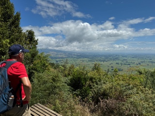
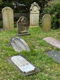
Since 3rd January we’ve been in New Zealand, exploring the North Island and getting to know the country. We picked up a rental car in Auckland and, with overnight stops over the course of three weeks, drove to Wellington at the bottom of the North Island. That’s 400 miles as the crow flies but will have been many more as we criss-crossed our way through the central backbone of mountains. All the while we marvelled at the amount of effort it must have taken for settlers to make their mark on the land. “Just imagine if you arrived here and the land you’d acquired looked like that!” John would remark every time we turned a corner to see yet more steep, tree covered slopes or dense bushland.  John looking out from the top of Mount of Kakepuku - he’s probably thinking “Imagine cutting that lot with a hand saw!" The two islands of New Zealand lie along the line of two colliding continental tectonic plates, the Indo-Australian and the Pacific. The idea that these islands straddle two different continents seems very apt as New Zealand’s population is a complex mix. We knew that New Zealand had been a British colony from 1840, but we didn’t realise that the Maori people had only arrived in these islands themselves in the 1300’s as New Zealand was the last large land mass in the world to have human inhabitants. We didn’t know that New Zealand’s government had actively recruited immigrants from South Pacific islands (particularly Tonga, Fiji and Samoa) in a bid to create a Pacific Empire. The Te Papa Museum in Wellington, the national museum of New Zealand, told fascinating stories of those who had immigrated as New Zealand developed; everything from subsistence farmers fleeing the potato famine in Ireland to wool spinners and weavers from England hoping to make a better life for themselves than was possible in newly industrialised Britain; from ex-convicts arriving from Australia to take part in the NZ gold rush of the late 1800’s to Polish orphans given a new start after World War II. New Zealand’s history is far from simple. We particularly enjoyed the story of Norsewood where we happened to stop for coffee on our road trip. The NZ government had purchased some land known as ’70 mile bush' from the Maoris and set about finding suitable immigrants to tame the difficult terrain. It was decided that the most likely candidates would be Scandinavian as they were thought to be ‘experienced farmers and woodsmen accustomed to frugal living and hardships’. A total of 752 Norwegians arrived in 1872-3, christened their new village Norsewood in honour of their home country and set about creating the community it is today. The street names reference their homeland and the Norwegian flag is still flown in the High Street. After we left Auckland we noticed that the use of Maori language on signs faded away and everything was in English. However, many of the place names are of Maori origin or have Maori meaning and we struggle a bit with the unfamiliar pronunciation. I don’t think we ever got the vowels in our first overnight stop - Te Awamutu - in the right order! Our second stop was Taupo, which was a bit more manageable. We were delighted to get back on a boat again on Lake Taupo, albeit that it was only a short trip to see modern Maori carvings in rocks on the lake shore.  There was such an outcry amongst the local population about the carving of these modern works of art that the artist (of Maori descent) carved the face of his ancestor with the eyes closed so that he wouldn’t see the uproar caused. We were quite surprised that our fourth stop turned out to be a ski resort snoozing its way through an out of season hot spell. Ohakune is on the slopes of Mount Ruapehu, the highest mountain on the North Island. It was here that Sir Edmund Hillary first became interested in climbing, after a school trip to Mount Ruapehu in 1935.  Mount Ruapehu We hired electric mountain bikes and had a fantastic time negotiating the ‘Old Coach Road’ trail. This 10 mile track used to be the only connecting route between two stretches of railway until they were finally joined together in 1908. Until 1908 passengers and goods were transferred from train to train in horse-drawn coaches along the steep, cobbled, winding track and across high, snaking viaducts. The going was hard enough with the advantage of a ‘boost’ button on the e-bike so goodness knows what it was like for the poor old horses!  On the ‘Old Coach Road’, Ohakune Ohakune was also the site of the first commercial bungee jumping business. AJ Hackett established the correct length of bungee to use by dropping sacks of potatoes from one of the old viaducts on the Old Coach Road. And on top of all that, Ohakune has the largest carrot statue in the world, a 7.5 metre high plastic model celebrating the quality of the carrots grown in its soft, volcanic soil. Moving on from carrots to grapes, we took the mountainous Taihape - Napier road across the middle of the North Island to the Hawkes Bay area, renowned for its vineyards. We were delighted to be able to visit the Unison Vineyard and friends Philip and Terry Horn who own and run it. The scale of grape growing in this region is impressive, with long straight rows of vines growing as far as the eye can see. We walked up Te Mata Peak with Philip and from our high vantage point looked down on the Craggy Range Winery where the former NZ prime minister Jacinda Ardern had been married a couple of days before.  Philip and John look down on Craggy Range Winery from Te Mata Peak. The vineyards grown on ancient gravel beds carved out by the river. Our last few days on the North Island were in Wellington, New Zealand’s capital city. We felt that its nickname ‘Windy Wellington’ was wholly justified as we clung to the railings at the viewpoint on top of Mount Victoria! In its early days Wellington streets had ropes strung along them so pedestrians could hold on to avoid being blown over. Wellington is also exceptionally hilly so we took advantage of the historic cable car to whisk us up to the top of the Botanic Gardens for a wander back down through the gardens to sea level. The Botanic Gardens were established in 1868 to assess the suitability of imported plants for growth in New Zealand and some of the conifers growing in the gardens are the predecessors of the thousands of acres of trees we saw on our travels. The scale of the timber industry is quite incredible.  These trucks with double trailers are common place on the roads, not just for logs but also for other goods. The final part of the pathway through the Botanic Gardens takes you through the Bolton Street cemetery, established in 1840 as the burial ground for the new multi-denominational population of Wellington. The intention of having a burial ground for all denominations set away from the various churches was to underpin the creation of an egalitarian society. This was somewhat undermined when, after much argument and disquiet, the cemetery was divided into three: Church of England; Jewish community; and general public! We were interested to see that the headstones in the area closest to the modern footpath showed the coming together of people of different origins in the mid to late 1800’s. The majority of the stones have English inscriptions but the one in the foreground has Chinese writing and the more ornate one (back right) has writing of a Maori or Polynesian type.  Bolton Street Cemetery, Wellington We spent several days exploring Wellington and the surrounding area on foot and by e-bike. Each day we would return to our hotel room glad of the chance to put our feet up. We’d just got back on one occasion when the TV mounted on the wall began to wobble and the contents of the room gave a little rattle. We were experiencing our first earthquake, just for a few seconds but strong enough (4.7 on the Richter scale) and lasting long enough for us to realise what it was! Those colliding tectonic plates mentioned earlier grate against each other enough to give rise to about 14,000 earthquakes a year. Thankfully, the one we felt was, as with the majority, noticeable but not dangerous.  The earthquake map nicely takes us to the next leg of our journey. We are now heading off to explore the South Island, taking the ferry from Wellington past the epicentre of the earthquake and landing in Picton on the other side of the Cook Strait. |