Lost. The final episode?
PASSEPARTOUT
Christopher & Nirit Slaney
Tue 16 Nov 2010 19:41
|
When I first learned to navigate with a sextant, my
instructor pointed out that most errors were in the simple arithmetical part,
one plus three making five, and not in the complexity of spherical geometry,
declination tables and converting minutes and seconds to decimal values. "Watch
out," he warned, "once you're at sea your I.Q. plummets."
Well these days I can report that it's on dry land where
my brain malfunctions. We got totally lost hiking on La Gomera, one of the
smaller islands in the Canaries.
The day started out well, fresh bread, good coffee, and
a map from the Officina de Tourismo. As the bus pulled out of the little town of
San Sebastian where we were tied up in the harbour, we looked forward
to a vigorous hike in the mountains and a village lunch. The plan
was to go by bus to a dot on the map called Arure, and from there follow a
trail down to the coast at a place called La Calera where we could
pick up a bus back to the harbour.
I studied the map of walking trails and remarked to
Nirit, "The Spaniards are really switched on. Look, the map says it's
compliant with satellite data WGS84, just like we use at sea." As it turned out,
this wouldn't be of any help.
Arure was a few houses, a bar and a doctor's clinic high
in the mountains. When we got off the bus it was smothered in low cloud, cool
and damp. We weren't dressed properly for this. Never mind, the walk would warm
us up and the trail would soon drop down into sunnier, drier lowlands. We
found the start of the trail, noted it was marked with stones painted in
red and white stripes, and set off.
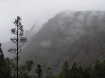
The scenery was spectacular and spooky; steep gorges
eroded from stark volcanic rocks. We made our way carefully down through
vegetation which was constantly changing from woodland, to succulent aloes,
dripping moss and even date palms. When the clouds cleared we could see the
ocean and so had a good reference as to how far we'd come, and how far
was still ahead.
After a couple of hours we could see the first houses
and small farms of La Calera. We stopped and ate a snack. It rained and we
were soaked. The sun reappeared to help us dry out while a perfect rainbow
formed over the end of the valley.
Eventually we arrived in La Calera where we knew
a side road would connect us to the main road a the bus stop. We
stopped and chatted with some German hikers who were coming from the
opposite direction. The lead German spoke English and told us to keep to
the left, "You can't miss it." We carried on down what should have been the
last few hundred meters and hit the beach. It was a wild place, huge black rocks
and crashing waves. Where was the trail?
Nirit and Roni hung back while I went forward to
explore. The beach looked a lot like the place in the movie "Shutter Island"
where Leonardo DiCaprio finds a cliff face cave overrun with rats and
a woman who was either an escaped asylum inmate of an apparition of the wife his
character had murdered. But no trail.
Retracing our steps we found a small house with a young
woman sitting in the doorway. In answer to our request for directions she told
us the only way was to walk back up to Arure and go over the mountain. We
decided she didn't know what she was talking about. After all, she didn't
look or sound local, just a visitor like ourselves. Either that or she was
a witch who could take on the appearance of a young woman in order to mislead
stray travelers. You can't be too careful or too paranoid.
Still retracing our steps and playing back in our minds
the conversation with the German hiker, we arrived back in the village of La
Calera just as a young man was parking his pickup truck. Nirit asked
him directions to the main road and he also pointed up they mountain
we'd just spent three hours descending. Dreading that I already knew the
answer to my next question, I asked him in my atrocious Spanish, "Senor, el
nombre questo pueblo?
"Taguluche," he replied, confirming what had just
dawned on me. Taguluche, not La Calera. Taguluche, at the bottom of a different
valley and miles away from where we’d intended.
"Autobus?" This from the ever optimistic
Nirit.
"No senora, no autobus aqui."
Would he give us a ride? No, he was done for the day.
Adios
There was nothing for it but to climb back up to Arure.
I asked Nirit and Roni if they were up for it and they agreed we didn't
have much choice. With three hours of daylight left, the rain had
returned and the temperature was falling. We were about to be victims
of the common mistakes people make when they go unprepared into the mountains.
We forgo the mountain track in favour of a tarmac road,
even though I could see it would add several kilometers to the ascent. We were
making good time but I started to look around for some decent shelter in
case we would have to spend the night in the open. We came upon some houses
but there was no one around, just a solitary barking dog. We plodded
on.
After one and a half hours of this a miracle occurred.
Down the road came a green and white taxi. We flagged him down. Yes, he was free
and he'd take us to Arure. A quick check of the now sodden timetable, with a bit
of luck we could make it in time to catch the bus we'd been aiming
for.
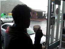
The taxi dropped us off with enough time to spare for a
reviving cup of coffee before the bus arrived. We'd made a classic mistake in
orientation; using map, physical marks and sense of direction believing we
were in one place when all along we'd been somewhere else. Our first
misstep had been the minute we set foot on the route; it was the wrong trail
from the get go. A handheld GPS which could have put us right had been left
behind on the yacht along with rain wear and binoculars. We asked
the German hiker the wrong question and refused to listen to the girl
in the doorway.
|