The beginning
(Mile Zero) of the ICW is deemed to be mid channel outside the marina in
Norfolk where we were berthed on Saturday and Sunday. Gone is the need
for the sophisticated electronics and huge admiralty charts Melv has been
relying on until now, and in truth I think he is feeling a bit bereft.
The navigation book we are now using (I wouldn’t give it the distinction
of “map” let alone “chart”) has an illustration of the
next eight or nine miles of the route showing each red and green buoy (or booie as the American’s pronounce
it….goodness knows how they get from “buoy” to
“booie”) and marks off each mile, in much the same way
you see the signs on the hard shoulder of the motorway. Next to the
illustration is a table listing all the buoys and any bridges and you are
supposed to tick them as you pass, with an indication of the time, in order to
keep track of exactly where you are. Although so very simple I have been
able to assume the role of Navigator, it is
useful because there are so few landmarks or distinguishing features to
determine your whereabouts.
From
first light we watched a flotilla of craft go past the marina and into the
ICW. We weren’t going particularly early because, according to the
ICW reference book, the first lifting bridge didn’t open until 8.30 am
(after the commuter rush, presumably). We duly set off and found three or
four yachts in front of us. Once we were all through the bridge which
only opened on the hour, the flotilla was in effect complete; as it was unlikely
other (motoring) would catch us up.
 The bridges went well but our first lock (The Great Lock, no less)
was a fiasco. I was detailed to stand on the bow and tie the boat to the
so-called dolphins set into the above-head-height wall of the lock whilst we
all waited for it to open on the half hour.
The bridges went well but our first lock (The Great Lock, no less)
was a fiasco. I was detailed to stand on the bow and tie the boat to the
so-called dolphins set into the above-head-height wall of the lock whilst we
all waited for it to open on the half hour.
I
wasn’t at all confident about this manoeuvre – and I did tell
Captain Bligh as much. The gentle glide in behind the yacht in front did
NOT go well, to the extent the lock master came out of his office and offered
to take the rope on the other side of the lock. I was berated because of
my unreasonable reluctance to lean out over the rail and put my head, arms and
upper torso between the moving boat and the concrete wall in order to affix a
rope.
Immediately
after the lock was the Great Swing Bridge (see photographs). If you think
it doesn’t deserve its name take a look at the mechanism for lifting it
up.
 Unfortunately we weren’t able to take the Dismal Swamp route
as it was too shallow for the likes of Zarafina. Indeed the depth of the
ICW in general is problematic for a yacht with a 6ft draft. Keeping
between the red and green buoys is vital as they mark the deep (and official)
channel, but even so the channel is prone to silting up and shoaling and so one
eye has to be permanently on the electronic depth indicator. Going aground in
tidal waters it is often just a question of waiting for the tide to come back
in to lift the boat off, but on the ICW you don’t even have that
option. A sailor we met in Deltaville, who had sailed the ICW five times,
strongly recommended we took out membership of Boat US because that would
entitle us to free tows. He told us the cost of towing can run into the
hundreds of dollars as you are paying on an hourly basis from when the tow boat
leaves its home port. We took his advice and although it cost a little
more because we didn’t have a US residence, we may yet find it was $165
well spent.
Unfortunately we weren’t able to take the Dismal Swamp route
as it was too shallow for the likes of Zarafina. Indeed the depth of the
ICW in general is problematic for a yacht with a 6ft draft. Keeping
between the red and green buoys is vital as they mark the deep (and official)
channel, but even so the channel is prone to silting up and shoaling and so one
eye has to be permanently on the electronic depth indicator. Going aground in
tidal waters it is often just a question of waiting for the tide to come back
in to lift the boat off, but on the ICW you don’t even have that
option. A sailor we met in Deltaville, who had sailed the ICW five times,
strongly recommended we took out membership of Boat US because that would
entitle us to free tows. He told us the cost of towing can run into the
hundreds of dollars as you are paying on an hourly basis from when the tow boat
leaves its home port. We took his advice and although it cost a little
more because we didn’t have a US residence, we may yet find it was $165
well spent.
 The navy boatyards ran for miles and miles but eventually we were
into open country. There were no banks to the canal as we passed.
The trees grew right at the water’s edge and whether the result of
climate change or what, we saw perfectly formed trees now sticking out of the
water, some distance from the shore. The trees eventually die and leave
what look like bare telegraph poles behind, or uproot entirely to add to the
vegetation debris at the water’s edge. Branches, logs and entire
trees float out into the channel and present a real hazard to boats.
Sometimes you see the end of a log, but it doesn’t move and is
(presumably) an entire trunk embedded in the silt.
The navy boatyards ran for miles and miles but eventually we were
into open country. There were no banks to the canal as we passed.
The trees grew right at the water’s edge and whether the result of
climate change or what, we saw perfectly formed trees now sticking out of the
water, some distance from the shore. The trees eventually die and leave
what look like bare telegraph poles behind, or uproot entirely to add to the
vegetation debris at the water’s edge. Branches, logs and entire
trees float out into the channel and present a real hazard to boats.
Sometimes you see the end of a log, but it doesn’t move and is
(presumably) an entire trunk embedded in the silt.
The
trees are only just turning here and the temperature in Norfolk touched
70....yeeeessss!
 We weren’t intending to be over ambitious, partly because we
couldn’t predict the delays we might experience at the lifting bridges
and partly because the first marina was too far to reach in a day anyway.
Our plan was to anchor overnight at 30 miles, do the 20 miles to the marina on
Tuesday and then a long day’s motor across comparatively open water on
Wednesday. There were three anchorages shown at the 30 mile mark, but
with the proviso the depth had to be checked (one
also mentioned looking out for water skiers but we didn’t think that
would apply in November). We were going for the second of
these when we noticed the other yachts in front peeling off and heading for a
derelict marina opposite the first of the recommended anchorages. We
gingerly left the comparative safety of the channel to explore the possibility
of anchoring and almost immediately touched the bottom. Melv did a U-turn
and went back to try the first site. As we approached the sailors on the
yachts hailed us and suggested we tie up next to them, which is what we did and
how we ended up with three other yachts at the least
luxurious marina on the ICW. Later that evening two Canadian yachts
joined us.
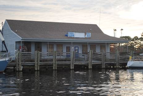
We weren’t intending to be over ambitious, partly because we
couldn’t predict the delays we might experience at the lifting bridges
and partly because the first marina was too far to reach in a day anyway.
Our plan was to anchor overnight at 30 miles, do the 20 miles to the marina on
Tuesday and then a long day’s motor across comparatively open water on
Wednesday. There were three anchorages shown at the 30 mile mark, but
with the proviso the depth had to be checked (one
also mentioned looking out for water skiers but we didn’t think that
would apply in November). We were going for the second of
these when we noticed the other yachts in front peeling off and heading for a
derelict marina opposite the first of the recommended anchorages. We
gingerly left the comparative safety of the channel to explore the possibility
of anchoring and almost immediately touched the bottom. Melv did a U-turn
and went back to try the first site. As we approached the sailors on the
yachts hailed us and suggested we tie up next to them, which is what we did and
how we ended up with three other yachts at the least
luxurious marina on the ICW. Later that evening two Canadian yachts
joined us.