Day 25 - Bermuda to Guernsey (arrival)
Stravaig'n the Blue
Sat 18 Jun 2022 22:35
Position: 49:25.35 N 002:32.7 W - Moulin Huet Bay, SE Guernsey Position timestamp: Saturday 18 June 2022 02:50 (UTC+1) Distance travelled in last 12.8 hours: 77 NM (average speed 6.0 knots) Reduction in distance to destination: 75 NM Shortest distance to destination: zero (we are here) We dropped the sails when the wind disappeared at about 6pm. The flood tide didn’t really kick in until about 7pm but from then until near midnight we averaged 8 knots on the incredibly flat water. This shot was taken at 8:15pm. 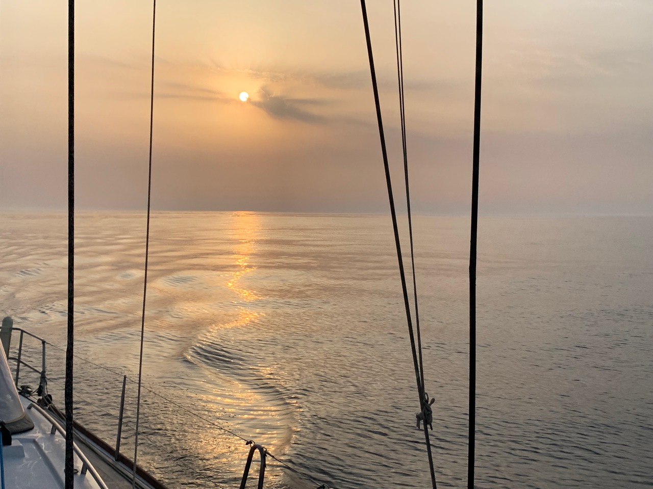 From midnight, with the ebb against us, progress was slower but it did mean that I managed a full off-watch sleep between 11pm and 2am, Linda having managed a few hours' sleep between 8pm and 11pm. (We were very disciplined and didn’t allow the fact that we were almost there to disrupt our watch system.) At 2am we were 2 miles from Moulin Huet Bay. It was at that point I remembered we were no longer in the Bahamas, anchoring in depths of 3 metres and with so little difference between high and low water that there was no need to take tidal range into account when calculating how much chain to let out. The tidal range in Guernsey can be more than 10 metres, so not something that can be ignored. Our chosen anchoring area’s chart datum (lowest depth) was between 4 and 5 metres and, at 3am there would be 2 metres of tide on top. Therefore we’d be looking to anchor in 6 to 7 metres, requiring 25 to 30 metres of chain. However, the following morning, at high water, there would be almost 9 metres of tide on top of chart datum, so a depth of 13 to 14 metres, requiring 50 to 55 metres of chain. Good to know. Moulin Huet Bay is quite wide, quarter of a mile side to side, but there’s a massive rock right in the middle of it. The half moon was partially obscured by clouds so wasn’t much help. Our chartplotter was showing two other boats in the bay and we could see their anchor lights. We had to approach reasonably fast because of the 3 knot current running east to west across the entrance and then adjust quickly as we got beyond the entrance and the current switched direction as it swirled around the bay and out. In the dark, with nothing but the cries of the seabirds on the cliffs that surround the bay, it was quite eerie. We came to a stop as we reached our chosen spot in just under 7 metres and, as Linda gently reversed the boat, I paid out 30 metres of chain. After I put a nylon snubber on the chain to take the load of the windlass, Linda increased the revs progressively to 1800 and we established that our holding was good. I then paid out another 30 metres of chain to take account of the next high tide. The time: 02:50, 584:45 hours and 3498 miles after leaving Bermuda. 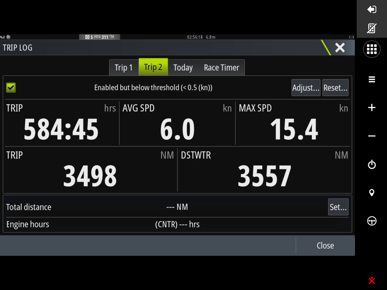 We’d averaged 6.0 knots and at some point had managed 15.4. That latter figure is highly suspicious. While it was tempting not to set a wakeup alarm, we knew we had to be off reasonably early to ensure we had the tide with us on the last few miles to Saint Peter Port. However, setting the alarm for 8am did mean five hours of uninterrupted sleep, two more than either of us had had in the last 24 days. Throughout Friday, the French maritime authorities had been broadcasting warnings gale force winds from the north-east from noon on Saturday until early on Monday. By 8am this morning the wind was certainly up. After a swift breakfast, so swift it didn’t include a coffee, we upped anchor and headed out of the bay, leaving behind one of the two boats, a blue water Oyster I think, that had been there the night before.  The last time we were in Guernsey we had the Victoria marina, the marina for visiting yachts, to ourselves. It was May 2020 and we were the first boat to turn up post lock down. We were given permission to stay but the regulations were changed shortly after our arrival and visiting yachts were only allowed to stop to take on water and fuel before having to move on. What a difference two years makes! This morning the inner marina was full with two, sometimes three, boats rafted together at each berth. There had been a local maritime festival yesterday that had attracted boats from France, the UK and the other Channel Islands and many were now extending their stay given the gale warnings. In the main harbour, before the inner marina, there’s a raft of anchored pontoons for visiting vessels to use when the inner marina is full. The raft is connected to the harbour by a bridging pontoon so that you can walk ashore as and when you please. Given how busy it was in the marina, we weren’t surprised to be told our only option was the raft and, given the gale force north-easterly forecast, we weren’t that surprised to be told that the bridging pontoon had been disconnected. Saint Peter Port harbour is well protected from most wind directions, the exception being north-easterlies which result in surge within the main harbour. The raft is anchored to the seabed at various points but there’s over 10 metres of slack in the anchor lines to deal with the rise and fall of the tides. With 30 or so boats tied up to the raft, in big winds and surge, the raft moves about a lot, especially at low water. Trying to keep the raft fixed to the harbour with the bridging pontoon is a lost cause. Luckily, the marina staff are more than happy to provide a ferry service ashore and back in their dories. So, shortly after tying up, we made it to dry land! Top priorities were a local SIM card for internet access (which is why this post has some photos) and fresh fruit and green vegetables. After paying an eye-watering $19/Gb for mobile internet access in Bermuda it was a joy to be paying only 71 cents/ GB here, a tad under what we were paying in the Bahamas. And just as well. 10 hours after buying the SIM card and paying for 35Gb (£20), we have used over 10Gb as our phones upload the many photos and videos we’ve taken to the cloud and our devices back themselves up and synchronise. Over the next day or so I will add some of these photos to the blog entries and tidy up a couple of mis-postings. The photos will include that Albacore we landed and some of Nereid, the 28 ft Pearson whose wake we crossed on two occasions. The entry formalities here are astonishingly simple, no matter your nationality or where you arrive from. When the marina dory meets you to guide you to your berth, you get a welcome pack containing a visitor’s guide to the island and a Bailiwick of Guernsey Report of Arrival of a Pleasure Craft form. This one page form requires some basic boat details, where you’ve arrived from and where you are going, and crew passport details. The skipper keeps one copy and posts the other into one of the yellow post boxes located around the marina. And that’s it unless the Customs Authorities, on processing the form, decide they need more information. But I’ve never heard of that happening. Everywhere else we’ve been manages to make an industry out of clearing in. The wind has been increasing throughout the day and is touching 25 knots in the gusts. But there’s more to come. This scary screenshot of windy.com shows the forecast situation tomorrow (Sunday) at 1pm. It shows 41 knot gusts at Saint Peter Port (top, middle). The problem system is the low (L1002) at the bottom of the screenshot, just above the north-west corner of Spain. Gusts here are around 60 knots. Many thanks to Tim for alerting us to this problem and thank goodness we had sufficient fuel to motor the last few days. Being caught in that would have been no fun. 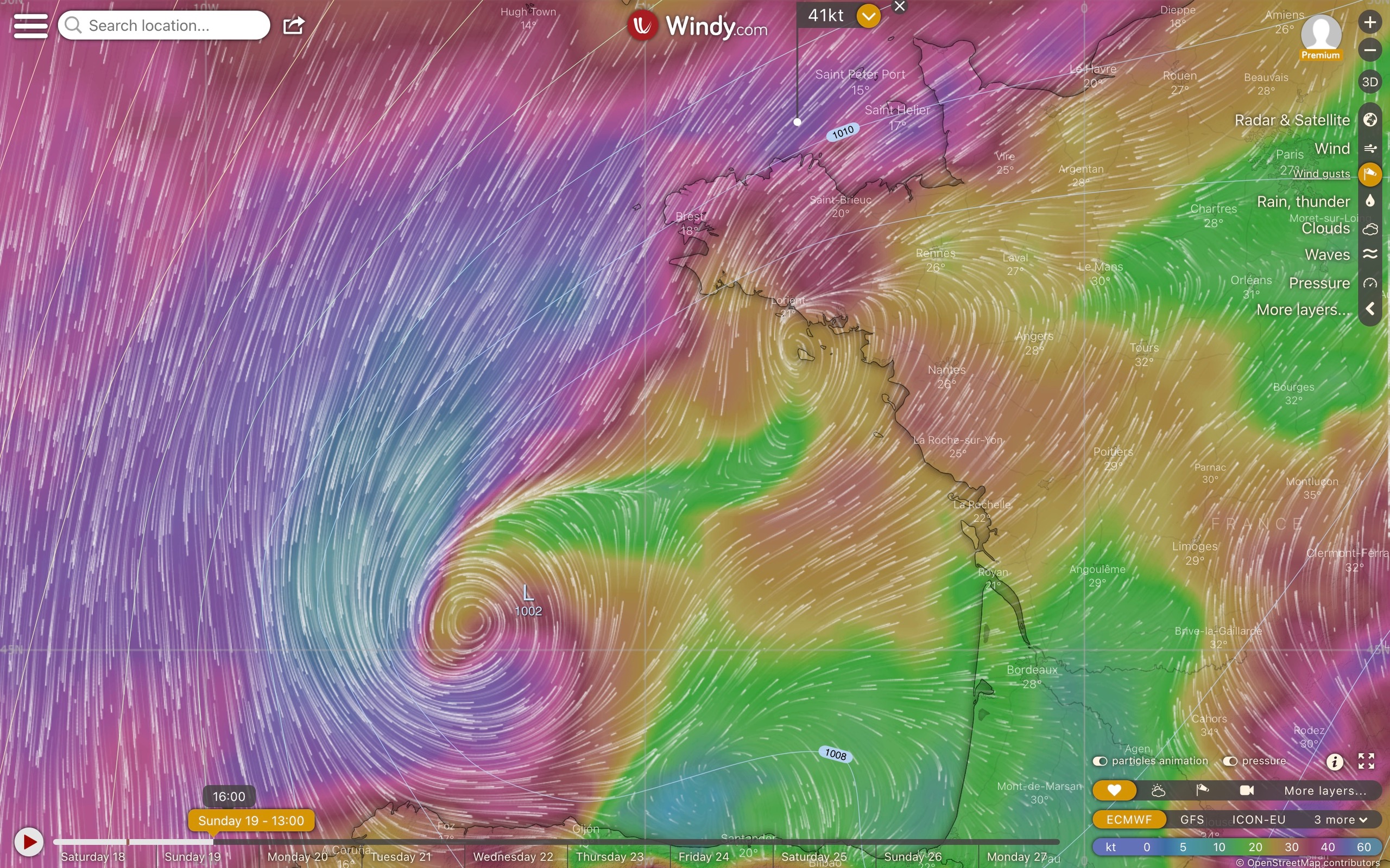 It is ironic. We had expected a perfectly calm first night in the marina but here we are, on the pontoon raft, being buffeted by the wind and the building surge. But I’m fairly certain neither will prevent us from having a very sound sleep. All is well. Allan
|