The Doldrums 09:12S 110:24W
Seaflute
Sat 22 Apr 2017 21:24
At the time of writing this blog, we are six days into our trans Pacific
passage. All crew are well and Sea Flute is performing impeccably as usual.
We are enjoying fine sailing conditions at last. Our route from the
Galapagos to the Marquesas takes us to ten and a half degrees of latitude
below the equator and more than forty degrees of longitude to the west. Most
of you will be familiar with the term "in the Doldrums" but some of you may
not realise it describes a band of weather just north and south of the
equator where there is generally no wind. The Bain of old mariners, who had
no option other than to wallow around for weeks on end praying for a breath
of wind to shift them south and into more favourable conditions. There are
many stories of sailors going insane during the wait and it was not uncommon
for many vessels to run out of water and provisions. These days we
fortunately have the option of an "iron sail" commonly known as an engine.
The dilemma as always is how far to travel off route to find a band of wind
and also how much fuel we can sacrifice and still retain enough for the
remainder of the voyage. The direct bearing of the Marquesas to the
Galapagos is around two hundred and sixty degrees. If we plotted a straight
line on our chart commonly known as a rhumb line and plotted waypoints along
it, and sailed this course, ironically we would end up sailing much further
than we need to. This is due to the way standard Admiralty charts are made.
If you imagine the globe as an orange, then cut the orange peel in equal
segments from top to bottom, then laid them out flat, this is the view of
the world used by cartographers and is known as a Mercator projection.
Obviously points on the extremes of the northern and southern hemispheres
are much closer together than they appear on the chart. If you draw a
straight line on this chart and then reconstruct the "globe" as our orange
demonstrates; this straight line becomes hugely distorted. To overcome these
anomalies we use a special planning chart which covers the south pacific and
is distorted to show the real distances and bearings between points. This is
called a "great circle" chart and by drawing straight lines between points
and then recording the latitude at the intersections between lines of
longitude, these points can then be transcribed onto a Mercator chart to
give you a great circle route. The prescribed route looks very curved, but
is actually the shortest distance.
The route we have chosen for Sea flute entails taking a route directy south
west until we are six and a half degrees south and then sailing the great
circle route from here to the Marquesas. At an average speed of seven and a
half knots we planned our passage to take twenty one days. We anticipated
motoring for the first three days solidly which would use half of our
available fuel for the whole trip. In practice we found light wind at four
and a half degrees which has then gradually increased the further south we
travelled. The bonus is we have more fuel in reserve for the latter stages
of the passage which are also predicted to have lighter winds. We continue
to download grib files (predictions of wind speed and direction to overlay
on our chart plotter) daily and adjust our course to take maximum advantage
of the wind available on our route. The subscription we have for wind
prediction uses weather information from multiple sources and has so far
proven to be fairly accurate.
So having completed fourteen hundred miles we are settled into our offshore
routine. Rachael is now confidently standing a watch which gives everyone
more rest time. Lindy has found her sea legs at last, so no more Stugeron!
This also means she can stay awake the whole day!! The days on passage pass
fairly quickly and our crew are kept busy with cleaning and maintenance in
between sleeping and cooking. The importance of staying alert whilst on
watch was brought home last night when two yachts appeared on our radar less
than ten miles either side of us. The other equally important job of the
watch is to spot wildlife as it passes and alert the rest of the crew who
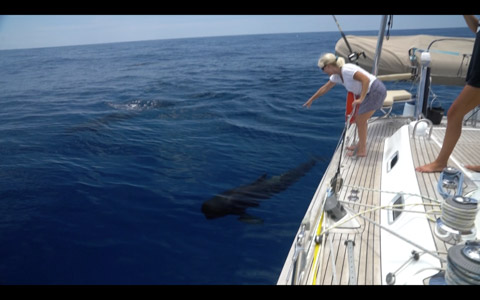
are always keen to see something interesting. We were totally spoilt on our
second day out. Lindy spotted a pod of whales just off our port side.
Fortunately we were motoring so it was easy to stop the yacht and move
slightly closer to them. A large pod of around eight Sperm Whales were
moving slowly along the surface and all around them were up to sixty pilot
whales. What was then amazing is that the Pilot Whales began to come towards
us in pairs to have a look at the yacht. They swam along our sides so close
you could have touched them. They were obviously very intrigued and rolled
onto their sides as they passed to get a look at what was above the
waterline and these strange creatures gawking at them and in Lindy's case
squealing with excitement. After an hour or so of watching this incredible
sight we reluctantly decided we should get going. We had only motored
another hour and the call "Whale ahoy" came again. This time a much larger
group of sperm whales were stationery in the water, half of them had their
noses pointing skyward. At this point, Tom could not resist getting his
snorkelling gear on and launching himself into the ocean. He slowly
positioned himself to be in their track but unfortunately for him they
obviously sensed him there and stopped for a while to evaluate this strange
sea creature in their way and dived under him just too far away to get any
photographs.
One of the high points of our day is the morning radio net. The net
facilitator calls up the fleet on the SSB radio at fifteen hundred UTC
(currently nine o'clock in the morning local but will change as we pass over
date lines as we progress west). Each vessel reports their position to the
nearest minute of latitude and longitude and the wind speed and direction.
As the fleet is now spread over around eight hundred miles, we can get a
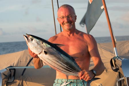
good picture of the wind patterns along the route. It's also an opportunity
to brag about who has caught the biggest fish, spotted the most wildlife and
most importantly who has had the fastest run in the previous twenty four
hours. We held the honours yesterday with a run of two hundred and eight
miles. This is also the record for the fleet so far, but I'm certain one of
the larger Oysters will smash this when they get into the trades proper.
There is obviously an element of competition amongst the owners and skippers
who all take pride in believing they can drive their charges the fastest,
however, we are also very mindful that with over three thousand miles of
ocean sailing, which itself will take its toll, we must not overstress our
rigs. Already we have four yachts sailing without mainsails, three have
broken mainsail furling foils and the fourth a broken gooseneck pin. They
now have the misfortune of sailing the remainder of the passage at a much
slower speed.
Our land fall in the marquesas must be Nuka Hiva which is the administration
centre for the islands and the only place we can check in. Unfortunately we
will pass several beautiful remote islands upwind of Nuka Hiva which are
difficult to get back to sailing upwind. If one were more relaxed about
this, one may choose to stop at Fatu Hiva the Eastern most island with a
stunning sheltered anchorage and very welcoming people who don't see many
cruisers, however this would be illegal, so we couldn't possibly..could we?
Anyway, I must get back to my skipper duties of bollocking the crew for
using too much water, leaving lights on and not cleaning enough. Life must
have been so much easier when keel hauling and flogging were permitted.
Bye for now.
Skipper Peds