Cruising the archipelago of the Canaries
|
The evening we arrived at La Gomera, we had a super meal
in a restaurant, recommended by a chap who had lived in We had hoped to meet with
Next morning we hired a car and drove around the island, mainly on elevated roads in the mountains, with their fair share of hairpin bends. Perhaps La Gomera doesn’t have as many tunnels as does
The scenery is just stunning with the most indescribably
beautiful mountains and ravines. From almost everywhere on the island, there is
a wonderful view. We drove through the national park and the dense forestation, some 600+metres above sea level. “More a cloud forest than a rain forest” said Philip and he spoke the truth. The predominant trees in the forest are related to the laurel and with their evergreen leaves, stay green all the year. There is a shortage of water here, so the moisture which supports this forest must come from the clouds, not that there were any around during our stay here. Sadly there is an aging population here as most of the young people leave, looking for an easier way of life than toiling the soil. A considerable number of terraces have been built, to assist the agricultural way of life and although many are cultivated, with grape-vines and plantations of bananas, as well as other crops, most of the terraces have either been left fallow or perhaps are now just neglected. There are a couple of other ARC boats here in this marina at San Sabastian, as well as one or two that are planning to cross the Atlantic independently. Everyone is very friendly and it is impossible to set foot on the pontoon without chatting to someone else who is also on a boat here. Monday is a fiesta, a Saints day and all the shops are
closed except the local supermarket which remained open until We had lunch on board and then left San Sabastian to travel to an anchorage near Valle Gran Rey, about 14 miles down the coast. The passage was not very pleasant with wind over tide and we were punching unto a force 6. We saw the small marina of Puerto de Santiago, after having traveled about half way to our destination. We hoped to shelter there for the night but we were not permitted to stay so we continued on to our anchorage, just outside of the marina of Puerto de Vueltas. There were already a few sailing boats at anchor and we joined them, putting out a kedge anchor in addition to the main anchor, so that the boat would face the swell, rather than the wind. While we were at anchor, during the hours of darkness, a monohull, also anchored here, sank to the bottom of the sea. The Spanish equivalent of the RNLI made a search during the night but returned in the morning to continue to locate the sunken vessel. We subsequently received a Navtex “Uncharted dangerous wreck, 8 metres long, showing a mast at low tide”. We spent an uncomfortable night here and left by
We arrived at the marina of Puerto de la Estaca around
Next morning, Dick went ashore and formalized our arrival and arranged for us to hire a car for the day. A chap arrived from the aeropuerto and drove us back there, to collect the car. At first it seemed as if there was a problem with the power steering but the “city” button had been left depressed by the previous user. I have to say that subsequently, we were very glad of the power steering. We traveled to the main town of
From there we drove upwards, across the mountain ridge towards the lighthouse at Punto Orchilla. It was a very scarey ride. Not only were the roads narrow and winding, in many places there was nothing between us and the sea below. We passed through the forest which was not as dense as in La Gomera and mainly consisted of pine trees. In a couple of places, the pines had been cleared and on a plateau, almond trees were growing. We could see where trees had been felled, chopped into logs and left, piled by the side of the road. Some of the more recently felled piles of logs, still had branches with pines needles attached. Just below, on the edge of the forest, a lot of fig trees were growing. There were so many that one has to believe that they are grown commercially. The last five kilometers of the road to the lighthouse was unmetalled. In fact, the ash and clinker, probably courtesy of the volcano, was possibly flattened, to make the road. Punta Orchilla, at the western tip of El Hierro, even until the 15th century, was considered to be the limit of the known world and from 1634 until 1884, when Greenwich was internationally recognized as prime meridian, Punta Orchilla held this status, along with several others at that time. When we arrived at the lighthouse, set within lava flow,
it was closed and in the process of being renovated for use as a restaurant and
museum. We had braved those sheer drops, to come here, to collect a certificate
stating that we had visited the most western part of
It seems that the certificate is now issued from an office in Valverde. The map given to us by the tourist office at the aeropuerto was not the latest issue and was out of date. No certificate but then, what would we have done with it even if we had obtained one? We chose the inner road for our return journey, rather than the coast road, fearing that the coast road might be even more frightening than the road across the mountain ridge. Passing through cloud at 1330 metres did nothing to relieve the fear factor caused by the sheer drops and clinker built road. Then, at last, the road was once again metalled and there were barriers on the side of the still winding road. Finally, we returned to the marina just after I am so pleased that we use big, round fenders. When the tide goes out, the fenders fall below the lip on the quay which is indented around 40cm, for the length of the wall. If we still used the cylindrical fenders supplied with the boat, we would have no protection from the concrete wall, as they would disappear into the gap. At 18.30 we ceased to be the only visiting boat here, when a French couple on a sailing monohull arrived and tied up alongside, ten metres in front of us. They will have to use their dinghy to reach one of the ladders, if they want to get ashore. Even at spring high tide, without a ladder, the wall of the quay is too high to access the dockside for all but the most agile. We left
Puerto de la Estaca at 8am. I was lucky to be on watch at We eventually switched on the engines just 9 miles from
Santa Cruz de la Palma, in an attempt to arrive before it became dark. We tied
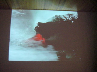
up alongside the reception pontoon at Next morning, we moved the boat from the reception pontoon to a hammerhead. Philip kindly hosed the salt from the boat, Dick went ashore to complete the entry formalities and then we were off again, in a hire car, exploring another volcanic island. The highest point on We visited the two volcanos on the southern tip of the island and walked around the edge of the crater created in the 17th century. The volcano which erupted in 1971 was close by. Saturday morning we left the marina soon after sunrise to
make passage to San Miguel, on Within two hours we were sailing and although the sea was big and uncomfortable, we were traveling at speeds up to 10knots. Mid afternoon Dick spotted six pilot whales but didn’t have time to call us as they only surfaced as we were passing them. As we came into the lee of
We tied up alongside having covered 77nautical miles in eleven hours. The berth was more comfortable than when we were last here as we were moored stern to the quay rather than alongside. Unfortunately, one of the lazy lines twisted round the starboard propeller while we were trying to berth, so Dick had to dive under the boat next morning, to free the line. In many marinas it is a health hazard to have to enter the water but the water here is very clean and clear.
Below:- Lighthouse at the end of the world Pictures of the volcano 1971
|