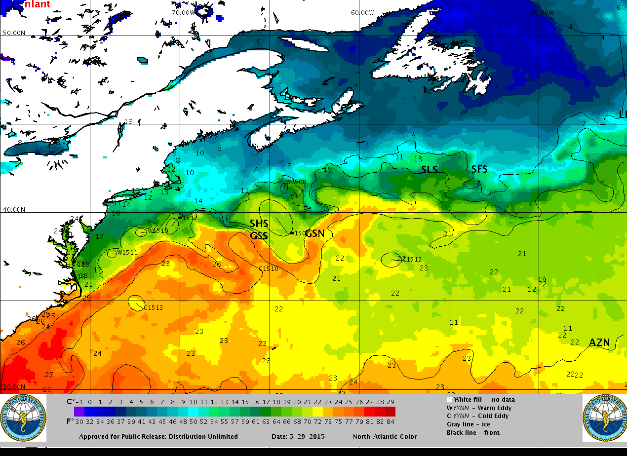
Gulf Stream
Blue Raven
Sat 30 May 2015 19:52
+1 310 465 7901
brian {CHANGE TO AT} blueraven {DOT} co {DOT} nz
-------- Original message --------
From: Commanders' Weather
Date:30/05/2015 07:36 (GMT-05:00)
To: brian {CHANGE TO AT} blueraven {DOT} co {DOT} nz
Subject: weather
To: Brian Russell and the crew on SY “Blue Raven”
From: Commanders’ Weather Corp, tel 603-882-6789
Route: Hampton, VA to Bermuda
Departure: Sun aftn, May 31, 2015
Prepared: 0730edt Saturday, May 30, 2015
Summary….
1) High pressure near 38n/49w (generally between Bermuda and the Azores)
a) the high is ridging W towards the eastern US
2) The high will edge a little SE on Sun
a) it will still be nosing W towards the Mid Atlantic States
3) Cold front will be over the New England and extending to a low over PA
a) the front will sag SE but stall well N of you
b) it will probably not get S of 39n (if that)
4) SSW wind early Sun will back and become SSE to SE for a time during the afternoon
a) flow increases to 10-15 kts and likely 12-16 kts for several hours during the evening
b) so, will have some head winds afternoon and the 1st part of Sun night
5) The wind then clocks and diminishes during Sun night
6) On Mon, weak low over the NE US
a) front will extend from this low down the eastern seaboard
b) the front will be moving E
7) High pressure remains well out in the Atlantic
8) Mostly a light S flow Mon
9) By Tues morning, the cold front will stretch from Cape Cod to just off North Carolina and then down to the Florida Panhandle
a) again, movement will be E
10) S flow will prevail
a) still a little uncertain whether the wind varies from SSE to SSW (basically, in the 160-200 area – leaning more to the S and SSW
11) Lightest conditions likely later Wed and Wed night
12) The front gets closer on Thurs, but think it stalls/fizzles to the NW of Bermuda
a) so, think you arrive without any fronts to deal with
13) May have a few showers or a t-storm Thurs as some activity develops out ahead of the frontal boundary
Routing…Hampton to 35 45n/74 30w (entering stream) to 35 10n/73 50w (exiting) to around 35n/70 35w to Bermuda -
Some estimated positions below
Wind forecasts
Wind directions are TRUE, wind speed in KTS, and time is UTC
Sun, May 31
08: 200-220/ 7-12
14: 140-160/10-15 departure around this time
20: 150-170/11-16
Weather…Partly cloudy
Seas 3-5 ft – ESE swell
Mon, June 1
02: 170-190/ 9-14
08: 180-200/ 7-12 nr 36n/73 55w
14: 170-190/ 6-12
20: 170-190/ 8-13
Weather…Partly cloudy
Seas 3-4 ft - ESE swell
Tues, June 2
02: 170-190/ 9-14
08: 170-200/ 8-13 nr 35n/70 35w
14: 180-200/ 8-13
20: 180-200/ 9-14
Weather…Variable clouds
Seas 2-4 ft – SE swell
Wed, June 3
02: 180-200/ 9-14
08: 170-190/ 7-12 nr 33 50n/67 50w
14: 170-190/ 7-12
20: 170-200/ 5-9
Weather…Partly cloudy
Seas 2-4 ft
Thurs, June 4
02: 180-200/ 5-9
08: 180-200/ 5-9 nearing Bermuda
14: 160-180/ 7-12 Bermuda
20: 180-200/ 7-12 Bermuda
Weather…Variable clouds. A few showers or a passing t-storm. Most activity afternoon
Seas 3-4 ft – SE swell
Best regards, George Caras
Commanders' Weather Corporation
Tel: 603-882-6789
Email: info {CHANGE TO AT} commandersweather {DOT} com
Website: commandersweather.com
Normal hours of operation: 5am to 5pm US eastern time, 7 days a week