26th April 2009 8'10.20N 98'20.49E
Well, back in Yacht Haven Phuket after a season of long, strange trips
all over the Eastern Andaman Sea, much entertaining of mates, many
adventures and damn near 2000 sea miles; though with the satphone off most of
the time, so no auto position update. And trips into the Thai interior, rain
forests and wild elephants, moon bears, exploring the Laos hinterland, voyages up and down the
Mekong, Pi Mai New Year festival in Luang
Prabang, and much, much more. None of which made it to a blog..
And I don’t intend to write in retrospect here. So instead, a short (published)
article about one of the lesser known aspects of Phang Nga Bay:
The Hidden
Corner of Phang
Nga Bay
Phang Nga
Bay is rightly regarded as
one of the most beautiful cruising grounds in the world. Tucked up into the far
North East corner of Phang Nga Bays lies a superbly sheltered, visually stunning
but seldom visited anchorage. Hardly anyone goes there – no tourist boats racing
hong-to-hong, seemingly no yachts - we have always been the only boat there -
the only other traffic the few, remarkably few, local fishermen in their long
tails. Far up Klong Bo Saen in Thanboke Khranee National Park, slap on the
border between Phang Nga and Krabi provinces, surrounded by lovely mangrove
rivers, sheltered by spectacular limestone karsts, lies this near perfect
anchorage, alive with bird life and in fish-teeming water; but no people – or
very few – all in all, a great place to get way, way away from it
all.
Getting there is not a massive challenge, there
being a 4/5mtr+ channel all the way up, though wandering off course can
occasionally create some heart-stopping readings from the depth gauge – those of
a nervous disposition would probably feel more comfortable going up and down at
mid-tide or better.
And so, the route: head north from the top of Ko
Yoi Yai up past Ko Chong Lat, keeping to the east of the bizarrely flat – for
Phang Nga Bay – sand island of Ko Mak, making to pass between the two imposing
100mtr+ limestone rocks, which have a very passable resemblance to the Pillars
of Hercules, transported to SE Asia. Passing between these, follow the charted
sweep of the channel north, then north east, then east towards the prominent
limestone karsk panorama appearing in front of you in the distant mangroves. The
channel is 5-10 mtrs all the way up the klong; but don’t be tempted to cut the
corner eastwards, that way lies not only shallows but some nasty, sharp-toothed
rocks below the surface, just waiting to spoil your whole day.
Follow the channel east for about 5 miles and you
arrive at a fork in the klong; the north branch, either side of a small islet,
takes you to the charming and totally unspoilt Muslim village of Bo Thor. For our anchorage keep to the
east fork and after some 200 mtr you arrive at an obvious anchorage at the
confluence of branches of the mangrove, protected on all sides by towering
limestone karsts. A more peaceful, contemplative place to spend a day and a
night would be hard to find.
Dinghy and/or kayak exploration of the mangroves
is an absolute must – this being the largest area of natural mangrove in
Thailand. It is possible to take a shallow draft
vessel all the way up the north fork of the klong to Bo Thor village, where
limited provisions and simple, but tasty Muslim Thai food is on offer from the
very hospitable locals, but by dinghy would probably be safer; and easier on the
nerves.
A must-see, however, lies in the other direction,
about a mile to the east: Tam Pee Hua Toe, the Cave of the Big Headed Ghost,
accessible only by dinghy or kayak. In this cathedral cave, full of strangely
shaped stalagmites and stalactites, is found the largest collection of ancient
wall paintings in southern Thailand – dozens of human and animal representations
from over 3000 years ago cover the walls and ceiling, including the eponymous
Big Headed Ghost. A few eco-tourist canoe trips come down from a road head a
mile or so further east – where there is a simple restaurant - but more often
you will be the only visitors to this and the many other caves to be found in
the mangroves. Something of a spooky, ethereal experience…..
So why do so few people come here? Well, it’s a
long way from anywhere by land, and the closer tourist attractions of
‘Jambon
Island’ and the like have a
greater pull, and of course better marketing. But a fundamental reason for its
neglect, I suspect, is that few people apart from the locals even know that this
peaceful verdant paradise exists. It’s certainly in neither of the bibles, those
guides written for Rough and Lonely people; nor the Pilot. You really do have to
go looking for it to find it in a sailing or motor boat, and with the depth
gauge sometimes unwinding at an alarming rate before your eyes at the entrance,
turning back can seem much more prudent an option. But it is only 10 miles north of Ko Yoi, it is 4 or 5 metres all the way up even at
low tide, and it is worth it when you
get there. Just don’t tell everybody….
Barry
Latchford,
20th March 2009
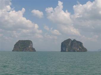
The ‘Pillars of Hercules’

Arkouda in the anchorage, facing east
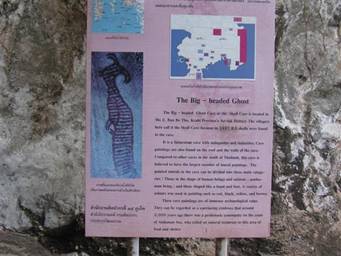
The cave of the Big Headed Ghost