A Man, a PLan, a Canal
|
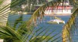
Panama. It’s not just a palindrome, indeed it’s not even just a canal, rather, with over 1700 miles of coastline, Panama is a major cruising destination in its own right. However all that was still 250 miles away, and for now the wind blew hard in Providencia. Fortunately Catalina harbour is very safe and sheltered in the prevailing N-NE winds so we felt happy to leave the boat during the day securely anchored in 6ft of water while we explored the island.
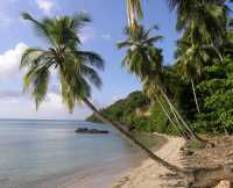
Some days we took walks around the island, finding deserted beaches and quiet restaurants. There is no mass tourism here, (that’s on Providencia’s sister island, San Andres, 60 miles further south) so generally only local people use the beaches and thus of course they are empty during the week.
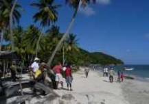
One Saturday all the weather bound cruisers went to the far end of the island (all of 6 miles away!) to join in a local beach party. Apparently these are monthly events designed to preserve and encourage local culture.
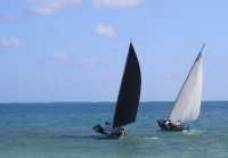
There was traditional sailboat racing with 6 crew per boat, all hiking hard. Bare back horse racing on the beach and a “Battle of the Bands”. Combining all this with lots of food and drink made it a fun day for everyone.
Eventually the wind began to moderate, and we left Providencia under just the genoa. Although Panama was over 250 miles away, we still had to judge our speed carefully as we wanted to arrive in daylight; so we didn’t increase sail even when the wind dropped. We arrived on a Sunday afternoon, but didn’t clear in until Monday morning, although that didn’t stop the Port Captain charging us an extra USD40 for overtime (in cash, no receipt).
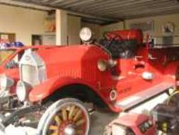
We had arrived in Bocas del Toro, a town at the entrance to a large lagoon in NW Panama, and somewhere that several people had told us we just had to visit. It was not much to look at as we arrived, but once we got ashore we saw its appeal. It was bustling with backpackers and surfers but especially with ex pat Americans buying land and houses. All the buildings are wood and so, since the town has twice been destroyed by fire, despite its age (note the wooden spoked wheels!), the local Fire Brigade made sure their fire engine was kept in immaculate condition.
We did some boat maintenance and office work for a week while we stayed at anchor in a west wind, which felt very strange after nearly a year of constant easterlies. But as Christmas approached we decided to celebrate in one of Bocas’ two marinas. And since we knew Eclipse would be safe, we could leave it to travel inland. Bocas was very hot and humid, and we’d quickly discovered that it has two seasons. The tourist brochures describe them as the Dry and Green seasons. We thought it more accurate to call them “Wet and Very Wet”!
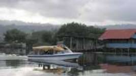
Bocas is on a peninsula and although there are cars in town and even an airstrip, to get to the rest of Panama one first takes a 20 minute water taxi ride on a very bouncy lake boat, which is not really designed for open water (Oh for a power cat!) to the terminus at Almirante. One of the least scenic places we’ve been to! And looking much the worse in the persistent rain.
I’ve written before about the differences between rich and poor. Panama is a prosperous country for most. But for many, especially the indigenous Indians, it is still a subsistence farming/fishing way of life, with only shacks for houses and no proper sanitation. We learnt that the general rule before swimming off a beach is to count the outhouses lining the shore.
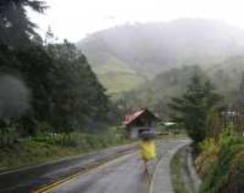
As always we were keen to get into the hills and thus find cooler weather. A five hour bus ride took us to David (Dav-eed), Panama’s third city, somewhere we found dry, cool and prosperous, a total contrast to Almirante. After a night there and another two hour bus ride, we arrived in Cerro Punta which is at 6000 ft and where we found the cold we had been looking for. Unfortunately we also found more rain.
Despite that we enjoyed the cool and also the novelty of wearing sweatshirts for the first time in three months. On the spur of the moment we rashly decided to walk the Volcan Baru trail to Boquete the next town, not just 10 miles away, but also the other side of the volcano. Had we planned it better we would have sent our overnight bags on ahead, instead we had to carry them.
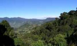
We got a lift in 4x4 taxi to the trail head and ranger station. Usually a 4x4 is bought as a status symbol. Here they are essential as the track was very rough. Large exposed concrete drain pipes were laid across the streams and big boulders littered the path making even walking difficult. The track climbed more and more steeply, at least a 1:4 gradient, but fortunately, as we got higher, the weather cleared and we had a great view looking back across the valley.
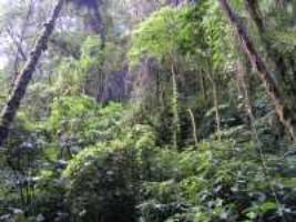
So we paid our 5USD park fee, were shown the puma footprints left from the night before and at 8.30am started off. As always we were lulled into a false sense of security. “This isn’t too bad” we told each other. But the path got gradually steeper and muddier. Slipping and sliding we fought our way ever upward through the jungle.
It made us realise just how tough it was for the early explorers. We had a path to follow and knew where we were going. Furthermore, we knew the noise in the distance was made by howler monkeys rather than by some man eating beast. Above all, we were pretty confident that we’d survive the day. One hundred years ago at least one-third of the settlers died of yellow fever or malaria.
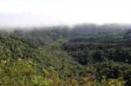
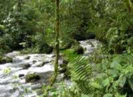
We keep hearing that the rain forests are destroyed and that all the jungles are cut down. Well, to us it still seemed very green and lush as we climbed the pass to 8000ft. Eventually, after several hours walking; we reached the midway point and the viewing spot.
In theory you can see the Caribbean from here, but it was too cloudy for us. We did hear more howler monkeys though, and could also see that we still had a very long way to go…
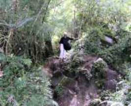
After a short lunch stop we started the descent. At times it seemed almost sheer and for about a mile it was a real scramble. We were so glad we weren’t doing the hike in the other direction!
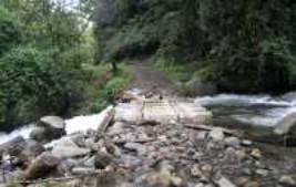
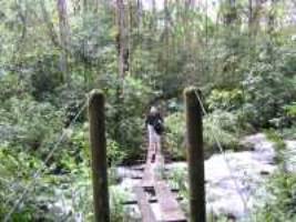
We kept re-crossing the river, sometimes over stepping stones, occasionally over rickety hanging bridges.
For the last couple of miles the trail levelled out and the going became soft rather than boggy. Then at 2pm we reached what we thought was the end of the trail. Farm buildings appeared and we began walking along a dirt road. “Boquete must be just round the next bend – after all the last sign said Boquete 3Km” Half an hour later we passed another sign
“Boquete 4km” We’d now been carrying our bags and walking/scrambling steadily for nearly 6 hours and the prospect of another couple of hours of the same was daunting. But we had no alternative except to carry on until at long last we reached the ranger station. No phone, so no taxi. “Only 40 minutes walk downhill to Boquete,” the ranger said. Two hours later we got a lift in the back of a pickup carrying carrots. Five miles further on we were dropped at the outskirts of Boquete. From there a 5 minute taxi ride took us to a cheap hotel. Next day we didn’t move. Then it was back to the boat and Christmas dinner in the marina restaurant. On the 27th we got our Zarpe (clearance papers) from the Port Captain and headed off east towards the canal and the San Blas.
Providencia to Bocas del Toro |