Where the Hell is Roatan?
Eclipse
Fri 3 Dec 2004 20:36
|
Asks the front
of the T shirts. The answer on the back is "between Utila
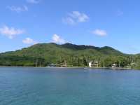
and Guanaja". The real answer of course is that they all comprise the Bay Islands, about 30 miles off the N coast of Honduras, and about 120 miles east of the Rio Dulce, Guatemala, where we had spent the hurricane season. Unfortunately sailing east along the Honduran coast is renowned as one of the worst sails in the Caribbean as it is to windward, in trade winds accelerated by the high mountains of the Honduran shore and against an adverse current. Furthermore there are no good harbours apart from those in the Bay Islands. So we weren't looking forward to the next 300 miles, especially since we hadn't been sailing for 6 months. Thus we were quite happy (if a little bored) to mainly motor sail in a light northerly wind from Livingston, Guatemala, to Puerto Este at the east end of the western-most Bay Island of Utila. This is a safe harbour with an easy entrance so we sailed, rather than motored in. Before setting out we had heard mixed reports about the Bay Islands. One cruiser we met said it was the most beautiful place he'd ever seen. Others said it was just a hippie/backpacker hangout, and that Roatan in particular was dangerous and thievery was rife. But all agreed that the mosquitoes and especially the sandflies were voracious. We had a good first impression, though, when we came to clear in, as it only took 20 minutes and cost 5USD (Guatemala was about 50 USD to clear in and the same to clear out). Otherwise we weren't that impressed with Utila, true it may be the cheapest place in the world to get scuba certified, but there's not much else going for it. As a major diving centre we had certainly expected the water to be clearer than it was. So after a couple of days it was on again, with a day sail to Cayos Cochinos, which is a small group of islands forming a Marine Reserve where no anchoring is allowed. Fortunately a hotel has put down some free moorings for cruisers. In high season as many as 20 boats use them, but in mid November we were the only boat there. We found the Cochinos to be much more tropic-islandish. The two bigger islands were high and tree covered, while the six or so small cays were covered in white sand and coconut palms, so quite pretty if you like that sort of thing.  One of them, the smallest (only about 5 acres) is home to several
hundred
people who fish way out to sea in old dugout canoes. There is no electricity, or, for that matter, fresh water on the island, so they were all desperately poor but quite friendly. Some of the Bay Islanders speak Spanish, some English, but with very upper class cultured British accents, just like the queen - quite strange. We could never tell until we spoke to them which language we would have to use. Because of what we had heard, rightly or wrongly, we missed out stopping in the main Roatan harbours. Instead we stayed in Old Port Royal at the island's east end. We were the only cruiser anchored in a very safe bay, with only one house visible on shore. Roatan is suffering an influx of (mainly American) ex pats and we had passed a long ribbon of big homes along the water front, just like in Florida. We stayed a couple of days, basically until the rain stopped - for it had rained on 10 of the 12 days since leaving Guatemala. In 1998 Honduras was hit by hurricane Mitch. Ten thousand people died and much of the country was destroyed. Particularly hard hit was the next island we visited, Guanaja. Even 6 years later dead trees and destroyed homes were very much in evidence. But things were looking up. Guanaja is a pretty island with friendly people, and not much spoilt by wealthy newcomers. 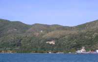 We spent a couple of days on a mooring at Grahams Place on Josh's Cay. This was a true Caribbean dream island. Better still, it's owned by an American whose hobby seems to be running a hotel without guests. It was great for cruisers; we had free water, free moorings, free ice. And since we were there for Thanksgiving he even supplied us cruisers with a free Thanksgiving dinner! Definitely a "must visit" place for anyone in the area. Unfortunately, the weatherman on the 8am cruisers net on 8188 said that now was the time to head east as the tradewinds would only be 15 knots. So we motored back to Bonacca Town for some last minute shopping. The vast majority of Guanaja residents live on this offshore cay. Even so, it's a tiny town with no cars or roads, just walkways and canals, like a mini Venice. Clearing out was as easy as clearing in and at only 2USD was the cheapest we've found so far. Honduras certainly knows how to make cruisers welcome! 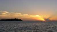 I guess the weatherman was right, as we never saw wind over 25 knots as we beat for 44 hours to the corner. But it was not a nice sail! Still we did better than Columbus, who took 4 weeks to sail along this coast. Not surprisingly he named the final headland Capo Gracias a Dios (Thank Christ!) once he'd rounded it. We didn't go as close inshore as he did, instead we headed for the Vivorillo Cays, 35 miles off the mainland. Two little deserted coconut palm treed islands inside a protecting reef and a favourite resting place for cruisers and shrimpboats. 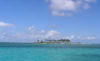 Next stop, 190 miles south of here, is the Columbian island of Providencia. Moderate NE trades were forecast for the next few days so we were hoping for a nice beam reach. But of course that's not what we had...
It all started off well enough, maybe even a bit too slowly to ensure a
daytime arrival
in Providencia. However, by late afternoon we were sailing in a big
cross sea towards
an unmarked, barely awash, coral reef which on the chart had the
ominous words
"position uncertain". We would be rounding it in the dark, and with no
moon,
we made very sure we kept well away!
All went well for Jetti's night watch but by dawn it was clear that the
weather had changed.
Big black cloud banks stretched from horizon to horizon and the wind was
beginning to
gust strongly. As the day wore on the clouds got more menacing and from
time to time
big squalls came racing towards us. In one the rain was as heavy as we've
ever seen it,
the whole sea flattening and turning white. We even saw a waterspout,
fortunately a
couple of miles away.
 In the next squall the anemometer high wind alarm (set at 30 knots)
went off repeatedly,
despite the fact that we were sailing downwind at 8 knots. Reefs in,
reefs out all day
and then about 2pm we saw the high hill of Providencia appeared dead
ahead (these days
gps landfalls are always dead ahead - a nice change from days of
old!). Nearly there we thought!
But we had one last squall to contend with, which was the worst of the lot.
One big wave hit us
broadside and everything went flying. Even a cup broke, the first
time that had happened since
leaving the UK. Fortunately, as often happens, after the squall passed to
wind dropped to nothing
and we motored the last 5 miles into Catalina Harbour at the north end of
Providencia.
 This has an easy entrance with lighted buoys (that makes a change!) and is
very protected from the
prevailing winds. We anchored in 8ft next to 3 other yachts, determined to
have at least a week's
rest before sailing on to Panama.
The map below shows the route from the Rio Dulce to Providencia
 |