FW: Blog Post 47 Cruising the West Coast of Panama – Punta Balsa to Panama City
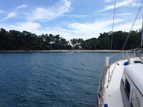
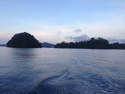
From: jirig nersesyan [mailto:jnersesyan {CHANGE TO AT} gmail {DOT} com] Blog Post 47 – Cruising the West Coast of Panama – Punta Balsa to Panama City 8:54.80N – 79:31.29W 09/10/16 – 10/01/16 Goodbye Costa Rica, hello Panama! Boy, were we glad to leave Costa Rica behind us! We had decided to buddy boat thru Panama with our friends from SV Gaia, SV Sirena and SV Mabruka. Our first stop was a 9-hour sail to Punta Balsa. The coastline of the west coast of Panama is jagged and rough and it has several large bays or gulfs along the west coast. There are large peninsulas jutting out into the sea. We had to round the first one, Punta Burica to get to Punta Balsa. Large peninsula’s that jut out into the sea make for strange bedfellows. They always affect the weather and the currents and upset the status quo. We got lucky and aside from a very strong counter current, we rounded safely. Punta Balsa is one of those anchorages where you just to stop to rest, it is protected from the wind and the swells, and has good holding for the anchor. There are no services ashore. In this case, there was not even a shack or a sign. You are basically there only because it is safe and comfortable and the crew needs rest. The only remarkable thing we saw there were plenty of Humpback whales. When we first started cruising if we saw a whale it was a big deal. We would yell and scream and everyone onboard would go up on the bow to watch. Now, they have become so common that we mention it lightly. Someone will holler “whales” and their location in reference to the boat “off of the port bow”. They are still spectacular to watch, especially when they come close with their babies. I have read that humpbacks are very common in Panama. They like the shallow warm water and calm bays to birth their calf’s and raise them in the early months of life. We got up early the next day and all three boats headed for the Isla Parida and the smaller islands surrounding it. It has been over a year, since we were in the Sea of Cortez, that we have seen uninhabited islands. One of our favorite things to do is to drop anchor off of an uninhabited island and go ashore and explore. There is a great sense of freedom in that for us. If there are no trails, we make our own. The islands were only 30 miles away so it only took a few hours. We wanted to make sure we got there with plenty of light so we could navigate our way in safely. We were leading the way in, with the other boats following in our path. I spent the time reading our new guidebook, ‘The Panama Cruising Guide’ by Eric Bauhaus. I cannot stress enough how important these guidebooks are for cruisers. There are guidebooks for almost everywhere that boat would want to go. We use them as if they are the bible. They are written by cruisers that have actually been to these anchorages and taken the navigational way points. They provide accurate maps that show hazards like reefs and rocks. They also give advice on things to do when going ashore and what services there are for cruisers i.e.: fuel, water, food, alcohol. Etc. So, I am now exploring a whole new guide to try and figure out which island we want to go to. The way we handle our cruise planning on the boat is that I read and do all the research about where we are generally headed (and where I would like to go!) and Jirig makes the ultimate decision on where we go regarding safe approach, anchoring and swell exposure. We decided we would stop at Isla Gamez, a tiny little island off the coast of the much larger, Isla Parida.
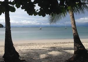
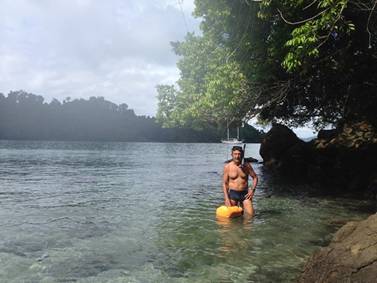
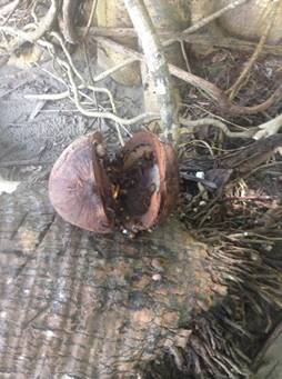
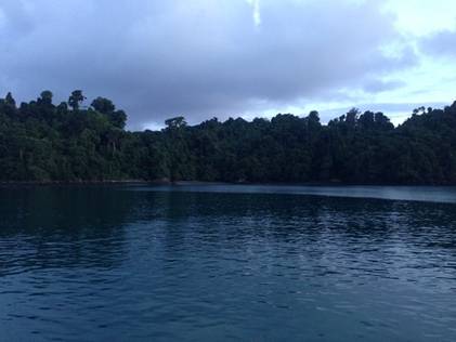
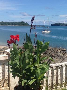
As we approached the island we were stunned. The water was aqua marine and you could see the sea floor at 100 feet. There was a pristine white sand beach with the lush jungle canopy beyond. It was just perfect. Down with the dinghy out with the snorkeling gear! There were reefs surrounding the island and tons of places to explore. We breathed a sigh of relief. It was great to be here. It was places like this that drew us to cruising. To be able to island hop down the coast, visit pristine uninhabited islands and stay as long as you want. We had no schedule. We had no deadlines. We could do whatever we wanted. We spent the rest of the day and the next morning snorkeling and exploring the island. There was only one drawback…. the bugs. Those pesky little “no-see-ums” tiny little black bugs that bite and leave a nasty bump that itches for days. The thing that makes them so insidious is that true to their name…you can’t see them. Therefore, it is very difficult to protect yourself from them. You do not realize until 12 or so hours after you have been bitten, when you start to itch and scratch. They are so small that they can get thru the mesh on the port holes and hatches on the boat. They say you need mesh screening that it as fine a ballet tutu to protect yourself from them. Good luck getting tutu size mesh where we are! We snorkeled ashore and then went exploring. There was only a narrow beach with 2 small hills densely packed with jungle. On the ocean side of this tiny island was a large reef. The ocean was very rough with swells and surge that made it dangerous to swim and snorkel. There were ominous clouds on the horizon so we headed back to the boat. We woke up the next morning to a glorious day. We had breakfast and another snorkel run around the island and we were ready to move on. As beautiful as this place was, we wanted to explore more. There were tons of islands ahead of us and we wanted to check them out. We packed up the boat and left around 1PM. We were headed for the Islas Secas. The Islas Secas are made up of 2 large islands, and several smaller ones. Isla Cavada was the largest island with the best anchorage. 1PM is late for us to leave, the best time to cruise around the tropics is in the morning before the heat and moisture saturated air has a chance to develop into anything. It was only a 20-mile sail from Isla Gamez to Islas Secas. The Secas islands are the northern most islands of Panama. They are a string of 16 jungle clad, volcanic islands that are 30 miles offshore from northern mainland Panama. Most are uninhabited and the few that are just have a small village.What 20 miles it turned out to be. Remember from posts past, when I talked about the gap winds coming across a narrow peninsula from the Caribbean Sea and creating havoc in the seas on the Pacific side? We experienced this phenomenon crossing the Gulf of Tuhuantepec in Mexico, experienced the Papagayo winds in southern Nicaragua on the way to Costa Rica and now, here as we are passing the narrowest spot on the Panamanian peninsula. The weather forecast we had downloaded via GRIB file the night before had winds forecast at 10-15kts, perfect sailing weather. Well that is not what we experienced. About 30 minutes into the trip as soon as we cleared the islands and entered the open sea the winds and seas started to blast us. At first we experienced winds 20-25kts coming from the east over the narrow peninsula and into the Pacific. The current and the swell were coming from the west. This makes for quite uncomfortable conditions. Sound familiar? It was like a flipping de ja vu to me! What we thought would be a leisurely afternoon sail turned into our worst trip yet. It happened very quickly. Fortunately, we have learned from prior mishaps how to secure the boat for conditions like this. This time there would not be a shit show in the cabin. Things got progressively more intense. We were now experiencing winds up to 35kts with gusts to 40. It was the waves that were killing us. The wind waves coming from the land were 6-8 feet and they were coming a 6 second intervals. The swell and the current was coming from the SE at 4-5 feet. The sea was like a washing machine on super charge. I decided I was going to ride this one out in our cabin, kicking back on the bed. All you have to do is anchor your foot on the steel bar that holds the mast to the hull and runs right through our room while lying in the bed and you are good. You get one of the big body pillows to bolster the other side and you are all set. Jirig and Nico stayed put in the pilot house. It is at times like these that you can really appreciate the pilot house. Most sailboats are open in the back with little or no protection from wind and waves. In conditions like this you would be soaked and freezing. The waves were crashing over the bow on both sides and sea water was pouring down the decks and down from the pilot house roof. Jirig had to turn off the auto pilot and hand steer, the conditions were just too rough for the auto pilot. For the first time, ever, Jirig was unable to write in his captains log every hour. He is a stickler for this. Every hour on the hour the sea conditions, latitude/longitude, engine checks and wave height, wind strength and direction and sea state must be logged in the Capitan’s Log. All of us crew have experienced his wrath when we have forgotten. Now it is habit for all of us. All it says on the Log Sheet for that day was: “Shit from Hell” “No time to log in “ “Auto Pilot Off” “Winds up to 40 kts” “Waves 6-8 ft.” “Miserable 4.5-hour ride” That kind of sums it up. As I lay downstairs in our bedroom, I thought of how far we all had come. When we started this journey my biggest fear was storms at sea. Now with 16 months of cruising behind us, dealing with all kinds of sailing conditions, storms, squalls, the lightning storms of El Salvador, the gale off of Nicaragua, hitting a reef in Costa Rica, losing the dinghy while underway in a storm, what else could there be? It was a good feeling to know that we could deal with the worst and still be ok. The conditions raging upstairs were the worst we had yet encountered but I felt safe enough to sleep. Our boat, our Captain and our crew were solid. The sea is a tempestuous place. You take what she gives, the good and the bad. What should have been a 2-hour trip took almost 4 ½. We approached Isla Secas about 6pm. It was raining and dark and gloomy. We found a good anchorage and set the hook. We settled in for the night and had a nice dinner. We could clean and wash down the deck of all the salt in the morning. Hopefully it would rain overnight and we won’t have to. One of the things we do to for entertainment is watch movies and TV series. We have binged on House of Cards, Game of Thrones, Suits, Walking Dead and tons and tons of movies. Cruisers all carry external drives full of entertainment and swap with each other. You do not need Wi-Fi all you need is power. Just like home…when you have watched everything on your drive, you share it with another cruiser and then get more from yet another cruiser. It is a great system. We get our movies, TV shows and music that way. Works great for everyone. What a difference 12 hours can make. When we woke up it was to another glorious anchorage with another island to explore. What was so stunning about these islands was first that the water was so clear, so aqua marina blue and another was that the towering jungle canopy came right down to the high tide line. There was only a beach at low tide. Isla Cavada used to be a private island but was just bought by the Smithsonian Institute for Tropical Research. Who knew that the Smithsonian had a Tropical Institute that bought islands in Panama? Makes my mind wander as it considers dooms day prepper conspiracies………. We would come across this institute many more times in our travels in Panama. The only trace of them on this island is a large sign that says that the island belongs to them. We were so close to the shore that we could just jump off the boat and swim to the island. Sounds like a simple thing, just grab your gear and go but it is not. I have to bring my Hydro Flask filled with ice water. We need the waterproof bags, towels, bug spray and sunblock and the waterproof camera and of course appropriate shoes for once we get on land. Jirig always gets frustrated with me because it takes me a long time to get ready (his perception, not mine) but I never leave the boat unprepared for most contingencies. As we went ashore the first thing we noticed is that on the island, everything on the ground seemed to be moving. Upon closer inspection, we saw that the ground was covered in hermit crabs. They were everywhere! They were crawling amongst the jungle debris, and as crabs are scavengers and will eat almost anything, we saw them eating rotten fruit, coconuts, and who knows what. We saw at least 50 of them eating one rotten coconut. It gave me the creeps.
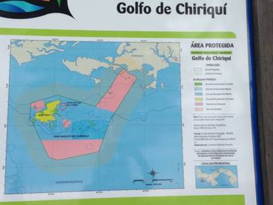
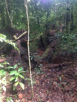
There was just too many of them. I wanted to get off the beach so I went looking for a trail or some clear path through the dense jungle. I found a trail and hollered for the guys to come. I wasn’t going into the jungle by myself. At the beginning of the trail was the Smithsonian Tropical Research Institute sign and then the trail led up about 50 yards into the jungle. We followed the trail as the jungle closed in around us. All at once we all started feeling bites. The ‘no see ums’ had lied in wait for us. We were being eaten alive by the tiny little blood suckers! My worst nightmare. We bailed out of the jungle so fast and ran across the beach to the water and jumped in. What an idiot I am. I brought the bug spray with me, but duh, it only works if you put it on. We got so caught up with the hermit crabs we forgot to put the bug spray on. On our run, back to the beach I found a coveted cowrie shell! A beauty to add to my growing collection. Despite the bugs, we liked it so much here we decided to stay another day. The next time we go ashore we will be prepared for those nasty little critters! It kind of funny when I think about it, when we told people our cruising plans included Panama everyone was shocked and warned us about mosquitos. And then while we were in transit here the whole Zika virus scare broke out in Central and South America and then spread to Miami. We have not been bitten by 1 mosquito since we have been here! You do not see TV or newspaper coverage here about the Zika virus. You don’t hear cruisers or other expats talking or being concerned about it. Once, while in El Salvador we saw a billboard on the highway that advertised a bug spray for mosquitos including the one that carries Zika, Aedes species. This is the same mosquito that carries and transmits Dengue fever to humans. That disease has been a mainstay and a scourge in Central America for a long time. Maybe the people here are used to treating that mosquito and disease and to add one more negative attribute, Zika, to that deadly mosquito’s harm, that they just take it in stride and it is no big deal. Or another, more likely, scenario is that the American press is just making too big a deal about the whole thing. If I was of child bearing age, I may be concerned, but other than that we do not fear Zika or, Dengue for that matter. We take great care to keep any bugs off of the boat and protect ourselves when we are outside (unless of course you forget to put the bug spray on!). At dinner, we talked about the route ahead of us to Panama City. We were stunned to think of how far we had come. The only thing ahead of us were the many beautiful islands of Pacific Panama. We decided we wanted to hang around a little bit, take it slow, and island hop our way to Panama City. The next island hop would be to Isla Coiba. Isla Coiba is the biggest island in the Mesoamerican Pacific. It is also a National Park and Marine Reserve. Recent studies show that it was inhabited as long ago as 500BC. The first white man to step foot on this spectacular island was Bartolome Hurtado of Spanish decent and then later it was a haven for pirates for centuries. In the early 19th century a penal colony was established here and that prevented any further development or exploitation here. (it probably saved the island!). The prison was finally closed down in the 1980’s. Isla Coiba is rich in diversity that includes many endemic species. It counts among its wildlife, Black Howler Monkeys, White-faced Monkeys, Black and Green Iguanas, the Needle Crocodile, various snake species and over 133 species of birds. It 1991 it was declared a Parque Nacional Coiba, one of the world’s largest marine parks, and has been protected ever since. Our guidebook claims that Coiba and the surrounding cays, are the most scenic islands on Panama’s Pacific coast. Well that sounded just perfect for us and so we headed for Isla Coiba. It was only a 31-mile run to Isla Coiba and it took a little less than 3 hours. Isla Coiba is huge. The entire island and the marine refuge is split up into 2 categories. One for scientific research and the other for eco-tourism. Tourists can wander into the scientific zones but the usual rules apply. Don’t leave any trash or garbage behind and do not take anything with you but photos. We had heard from other cruisers friends that had just come through this way, that if we anchored off of Isla Coiba we would almost surely be approached by the park rangers and would have to fork over the hefty park fees for anchoring and going ashore. The fees were said to be on a floating scale depending on the park ranger you encountered and could only be paid in cash. The posted rates were $20 per night per boat to anchor in the reserve and from $10-?? per person per night. That is where things got iffy. There was a beautiful little island off of the coast of the much larger Isla Coiba, called Isla Rancheria where we could anchor unnoticed. We headed there.
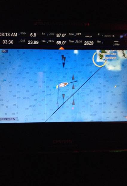
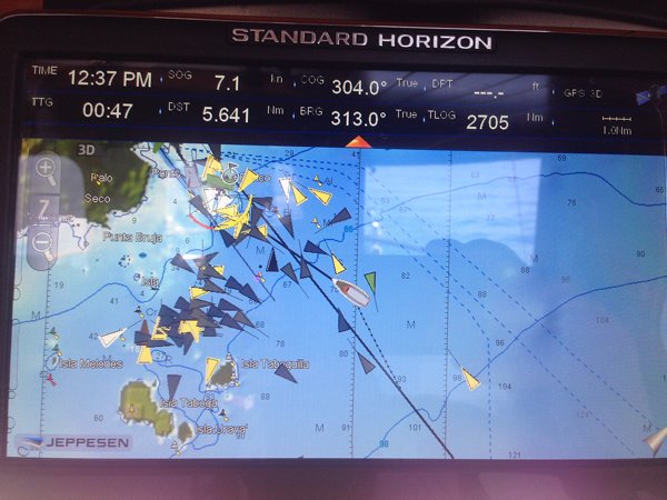
Isla Rancheria was paradise. If you painted a picture in your mind of the perfect tiny island, complete with white sandy beach, coconut palms and jungle surrounded by a spectacular coral reef, Isla Rancheria would be mine. All of the islands we have encountered so far in Panama are all just a little bit different. Some are obviously larger than others, some are just mangroves, some are dense jungle canopy and no beach. The part of the island that is exposed to the sea, or the windward side is different than the side that is not, the leeward side. The windward side usually has beaches, volcanic rock formations, rough surf and off shore hazards. The leeward side usually has calm water and mangroves, but not always. Their differences made them that much more fun to explore! What did we see as we were swimming ashore? None other than a Smithsonian Institute of Tropical Research sign stating that Isla Rancheria was no longer privately owned but was now theirs. What are they doing with all these islands? There seemed to be no signs of research going on here. We did our usual routine. Get the gear, go snorkeling the reef then swim ashore (bug spray in backpack) and check it out. Unfortunately, the one thing that all of these islands had was the proliferation of plastic trash. It is so tragic to explore this pristine, uninhabited island only to walk around the bend to the part of the island that is exposed to the sea and see all the plastic trash at the high tide line on the shore. One of the reasons that the trash gets so high up on the shore of these islands is the extreme tidal range between low and high tides on the Pacific side of Panama. The tidal range here was almost 16 feet! You would take your dinghy ashore at high tide and return at low and your dinghy could be 500 feet up the beach. And then you get to schlep the 750lb dinghy, complete with outboard down to the shore. As a result, we timed our shore sorties carefully. The fellow cruisers we had left Golfito with were now all spread out. One boat Sirena, had been moving quickly and was a day ahead of us. The 2 other boats Gaya and Mabruka were taking it slow and were a day behind us. We were all staying in touch via VHF radio. After spending the day and night at Isla Rancheria we had planned to head towards the mainland as we crept closer to the big Bay of Panama and ultimately, Panama City. We got a call over the radio from Serena. They were running out of fuel. Most sailboats have small gas tanks of 50 gallons or less. We on Savarona on the other hand have 2 diesel fuel tanks that hold a total of 1100 gallons. Instead of making them back track 50 miles we said we would rendezvous with them and give them some of our fuel. We changed our heading so that we would intercept with them at Punta Arenas. We met at the anchorage around sundown. The plan was to pump about 100 gallons of fuel from our boat into to their 5 gallon containers. When you do the math that is filling and schlepping 20 containers of fuel from our boat to theirs. After a long day of sailing that was the last thing anyone wanted to do. The engine room was a broiling 115 degrees and Jirig and Nico were down there setting up the fuel pump. To ease into this nasty task, I made cocktails for everyone (Nico got a Gatorade) and we set to the task at hand. It was a painfully slow process. We got the job done and even managed to eke out a decent dinner. This was one of those anchorages where you just spend the night and get on your way the next day. We were getting close to the Bay of Panama and needed to strategize our approach. We definitely did not want to approach Panama City at the end of a long cruise; we wanted to be fresh and to arrive during the day. As we looked into our routing, we decided that we would make an overnight stop in Banao. Banao is an anchorage near the tip of Punta Mala (Bad Point) another one of those lovely long peninsulas that makes up the northern part of the Bay of Panama. It was a 66-mile run that would take us about 10 hours. The plan was to spend the night there then head either for one of the islands in the Las Perlas Archipelago or straight to Panama City. We left the anchorage at first light and settled in for the trip. The weather report said there would be intermittent squalls throughout the day. Within the hour of our departure we hit one. It was pouring rain (my weather center literally said it was ‘raining cats & dogs’) We were getting hit with swells from the east and the west again but nothing as intense as a couple of days before. Nico and I went downstairs to watch a movie. We arrived at the anchorage around 4PM and were not impressed with what we saw. The anchorage was open to the SW swells and the anchorage waypoint were just too damn close to the rocks. Even though the guidebooks are helpful, ultimately the Captain has to make the decision based on his own judgement and the conditions he sees right in front of him. It was a bad anchorage in these conditions. Jirig said if we anchored here he would not sleep a wink and that it would be very uncomfortable and very rolly. We all agreed we should move on. We took a break, I made dinner while Jirig consulted the charts and we decided that we would head for the Las Perlas Islands. It was a good 105 miles away and would mean overnighter but it was better than staying where we were. We settled into our cruising underway routines, me reading, Jirig at the helm and Nico watching movies. The only problem with this plan was that we would be crossing the shipping lanes leading to the Panama Canal in the middle of the night. I cannot impress enough how busy those shipping lanes are. You have literally hundreds of ships, container ships, oil and chemical ships, mining ships, fishing boats and cruisers all competing for the same space. The closer you get to Panama City and the Canal the denser the traffic gets. The shipping lanes are clearly marked on electronic and paper charts. It is like a super highway for ships. We figured it would be best to do it at night with radar. The plan was for me to take the 8pm-12pm watch, then Jirig the 12-4am, then me the 4am-8am and so on, until we got there. My watch was uneventful. There was a spectacular full moon illuminating the sky and the weather was calm with winds at 10kts with 3-4 ft. swells. At the end of my watch I was exhausted. I wanted to stay up while we were crossing the shipping lanes but could not. The shipping lanes run east to west leading up to and out of the canal. The Las Perlas island chain we were headed for was on the other side of those lanes. Jirig had to plan a route across the lanes to avoid the big ships. These ships are going 10-15kts and weigh thousands of tons. They are unable to stop and cannot change course quickly. You get in their way; they will crush you. Remember, our home port was in the Los Angeles Harbor, one of the busiest ports in the world. We had to traverse the main shipping channel of the harbor every time we left the marina. We are used to big ships and traffic. That was chump change compared to this. I have attached a screen shot of our radar screen and our GPS navigation program for that night. We are lucky we are a motor sailor. We can gun our engines and do 9 knots if we have to. I cannot imagine trying to cross these lanes under sail. The attached photo of our AIS (automatic identification system that is required for any vessel over 100 tons. It identifies a ship, its name, size, equipment, destination speed and direction.) showing ship traffic that night is below.
The Las Perlas Islands are an archipelago in the Bay of Panama that consist of over 200 islands. They cover an area of 30nm north to south and 20nm east to west. The islands offer a wide variety of large and small, tall and short, jungle and mangrove, beach and reefs. You could cruise here for months and stay in a different anchorage or island every night. We were headed for a little island called Pedro Gonzales. These islands were recently made famous as the television series “Survivor” was filmed on Contadora and Saboga. It is not unusual to see Cruise ships packed with people cruising by these 2 islands so the passengers could see them. We would give those two islands a wide berth. The Las Perlas got their name when the Spanish Conquistadors Gaspar de Morales and Francisco Pizarro robbed a large amount of pearls from the indigenous King Toe. In 1515 they defeated the king and enslaved his skilled pearl divers. The 31-karat pearl “Peregrina” of Queen Mary of Tudor, came from these islands. As we headed to Pedro Gonzales we passed a private island called Isla San Jose. It is the 2nd largest in the archipelago. The owner has built, roads, a landing strip, a palatial mansion, a golf course, a fishing cabin and many out buildings. There is no traffic on the roads as the owner is the only one who drives here. How cool would that be to own your own island? He must be pretty rich. Probably a drug lord or something. Isla Pedro Gonzales is relatively small and has a village of about 500 people. There are several herb plantations that cover the interior of the island. Most of the villagers are fishermen or work on the plantations. We were the only boat in the anchorage. The water was clear and blue, just how we like. Even though we were exhausted form the overnight cruise we have learned that it is better to stay up for the day to try to maintain your regular sleep patterns.
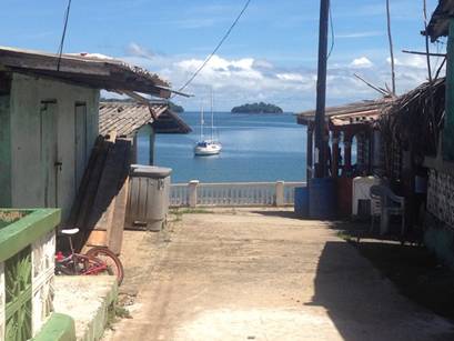
As we had been out cruising the islands, we had not provisioned since Golfito and were is desperate need of basic foodstuff, primarily beer, soda and snacks. There was supposed to be a few small tiendas ashore in the village. The village of Pedro Gonzales was small, with narrow streets, one story concrete buildings that were painted a myriad of bright pastel colors. The streets were clean and the homes were tidy. We definitely got some curious looks as we walked into town. Hey must not get a lot of boat traffic here. People were polite and helpful. We asked where we could get beer and cokes and were directed to a small house. There was no sign to indicate that it was a store. As I approached the door of a woman’s living room there was a small table at the door with some snacks and candy on it. When she looked at me as I approached, she spoke to me in Spanish. I was stunned. This woman and every person we had seen so far in the village was black. In my complete cultural stupidity and ignorance, I had never heard a black person speak Spanish before. I do not know what we expected when we got to Panama regarding the people we would encounter here, but in our ignorance, we assumed they would be like the people we had encountered so far in Mexico and Central America. As we learned more about Panama and how it evolved as a country, we found that Panama had always been a haven for immigrants.
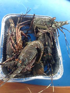
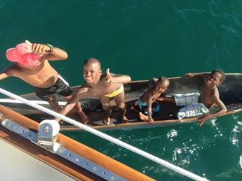
The first peoples here were the indigenous tribes of the Kuna and the Carib Indians, then there were runaway slaves from other islands in the Caribbean and the US, that came here seeking a new life for themselves. As the Canal was being built, massive amounts of labor were required and many black slaves and recently freed blacks flowed into Panama seeking work. Right alongside the canal the Panama Railway was being built that also required workers. Workers were brought in from China and India. The melting pot that is Panama, continues to this day. We felt like fools. Of course, black people here speak Spanish as that is the official language of the country and they had been here for centuries. I chatted with the ladies in the store as best I could and asked them where we could buy some beer. She directed us down the street to another house. A guy came out, greeted us warmly, and spoke perfect English and asked us to follow him. He went behind his house to a large shed with a refrigerator in it and went and grabbed us 2 six packs of the local Panamanian beer, called Balboa. They were only $1.00 per piece. With much needed provisions in hand we went back to the boat. As we were getting in the dinghy on the beach a fisherman came up and asked us if we wanted fresh lobsters. Well, hell yeah we do! And a fabulous lobster dinner was had by all. We talked about whether we wanted to see more islands in the Las Perlas or head for Panama City. Panama City won out. After spending almost 2 weeks away from any sort of civilization we wanted unlimited power, AC, and most importantly wi-fi. The resources and services for transient boats on the western side of the Panama Canal and in and around Panama City are pretty slim pickings. You would think that with all of the pleasure boats here that there would be plenty of marinas offering varying degrees of service but there are not. There is one marina at the very high end and several marinas and anchorages at the very low end. One of the challenges for marinas on the Pacific side is the extreme tidal range. With at 16-19-foot difference between high and low tide leaves many marinas with now water at low tide. Yes, that’s right, your boat sits in the mud. We are just not going to do that with our boat. The anchorages have no services whatsoever. No bath room, no showers, barely a dock to land a dinghy and a rusty old pipe provides the only water that comes from who knows where? We didn’t have much choice; we went for the high-end marina at Flamenco Island. The marina is huge, with easily a 1000 boats. 90% of the boats in the marina were Panamanian owned and 98% of them were power boats. Not little weekend sport-fishers either. These were multi-million dollar boats. You have to see what happens to a dock with a 19-foot tidal swing. The surge of water going in and out of the marina 2 times a day really tears things up. We had 8 docklines out for our boat and were still knocked around by the tidal surge. One night during a storm the main dock just 50 ft. from our boat broke apart. The next day the marina just put a wood 2X10 plank over the broken part and we all just climbed over it from there on out. The approach to Panama City was stupendous. You can see the wall of high-rise building and the bridges for miles off-shore as you approach. There was boat traffic everywhere. Tankers, cruise-ships, fishing boats, diving boats, ferries, military ships and local dugout canoes crowded the bay. It was insane. Here is a picture of our AIS showing the approach to Flamenco Marina. Most of the ships you see are anchored in the bay waiting to cross the canal. Our boat is in the middle.
The Secas islands are the northern most islands of Panama. They are a string of 16 jungle clad, volcanic islands that are 30 miles offshore from northern mainland Panama. Most are uninhabited and the few that are just have a small village. The Secas islands are the northern most islands of Panama. They are a string of 16 jungle clad, volcanic islands that are 30 miles offshore from northern mainland Panama. Most are uninhabited and the few that are just have a small village. As we got closer to the city we got very excited. Reaching the Panama Canal was a huge goal and milestone for us on this journey. We could not believe that we were so close to reaching it. We had traveled 4618 miles from Long Beach, CA to get here. We had been at sea for 16 months. Wow!
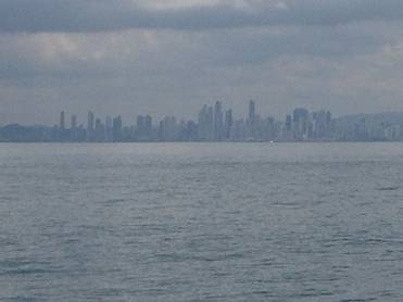
The city skyline is spectacular. It rivals the likes of the skylines of Manhattan, Hong Kong or Shanghai. We had not seen a city like this since leaving the US. As we motored into the marina a huge thunderstorm was approaching. Not 2 minutes after we got into our slip and tied down, the thunder, rain and lightning started as if welcoming us to the city. There was a huge crack and snap sound that was so loud and so close to the boat that it sent me running inside the pilot house. Never had lightening been so close to the boat. Thankfully it did not last long. We had grown accustomed to these storms. Our time in El Salvador had us well trained. We could not wait to explore the city. But first we had to check into the country. It is quite common for transient boats to sail south from Central America and not check into the country until Panama City. The only other place to check in where there is officialdom to support it is in the very north of the country in Puerto Armuelles. It is about 50 miles up a deep bay and is an industrial port with no services for cruising boats. It is also very expensive to check into Panama. It is $105 per person for a 90-day visa, that can easily be renewed for $5. It is $195 dollars for a 1 year cruising permit for the boat and other small fees to contend with. First you check in with the Port Captain. There was a port captain’s office near the marina but the Port Captain was never there during the posted hours on the door. We finally tracked him down, paid the fees and were sent to immigration. It is an $8 taxi ride to the office from the marina. We get there and the first thing they say is where are your photographs for your visa? I had extensively researched the check in procedures for Panama and nowhere did it say we needed pictures. The woman insisted and in broken Spanglish told us where we could get them. Just a 1 mile walk in the hot tropical sun, no problem. We ask the clerk in the store for 2 pictures for each of us and are told we must buy 6 because that is the only format they can print them in. Ok fine. Now back to immigration. Now the nice but uninterested and apathetic lady at immigration wants to see our cruising permit for the boat. We though you give that to us? No, she insisted you must get it from the Port Captain. Why did not Port Captain not say that when we checked in with him the day before ? We were in a marina after all, did he think we flew to Panama? After several trips to the Port Captains office only to find out he was not there, then we finally pinned him down. Oh, yes, he said you must have a cruising permit. Finally, with cruising permit in hand we took another taxi to immigration office in the city. This was getting expensive. We had been in the country for 4 days and were still not officially checked in. When we got to immigration the same lady told us that we could get arrested and fined for not having a visa. We are trying lady, we are trying! There were many things we needed to do while in Panama City for the boat. We needed 4 new house batteries, we needed a new dinghy, we were still fooling around with the generator etc. So we busied ourselves with gathering the parts and provisions we needed. You can find anything you could ever want in Panama City. There are numerous first class malls, open air markets and more restaurants serving delicious international cuisine than you could imagine. The thing that struck us most about Panama City was its diversity. All cultures are represented here. There are people of every race you can think of. Chines, Lebanese, Persian, Japanese, Americans, Europeans and South Americans. The Panamanians themselves are a diverse group. They are a blend of indigenous tribes, Spanish, Chinese, Indian and Caribbean blacks. Unlike in Costa Rica, where intermarriage among races is frowned upon, here it clearly is not. We would stick around Panama City, explore, sight see and prepare for our canal crossing over the next 2 weeks. Our son Daniel would be flying down to join us for our Panama Canal crossing. We wanted to do it as a family. |