What We Knew But Forgot When Sailing Offshore
28:49.0S 32:06.8E
What We Knew But Forgot When Sailing Offshore
We would like to believe that, since we started sailing around the world in January 2010, we have learned a lot about cruising and the challenges of a long-distance, blue water circumnavigation. This is a story about what we learned but forgot along the way.
Earlier this week, we made a short trip of only 90 miles
from Richards Bay, South Africa heading down to Durban.
I’m about to tell you how everything that could go wrong did and how it
could have easily been avoided!
To start the day out, we had to deal with Immigration, Customs, Port Authority and Police! In South Africa leaving one port and sailing to another, even if it’s within the country, requires a lot of paperwork. Both checking in and checking out entails visits to separate offices of Immigration, Customs, Port Authority and the Police Department. My travails began when I went to the wrong office of Immigration and waited for two hours for my number to be called only to find out that there was a separate office for domestic immigration! This was our first “shoulda, coulda, woulda” mistake! ALWAYS ask multiple times where you have to go and who you need to see to satisfy the “powers that be.”
You also need to bring many, many copies of all your paperwork such as vessel registration, crew lists and other documentation. It seems that none of these government agencies EVER have a working Xerox machine and everyone seems to need a copy of your paperwork for their files! Sharing this information via an interfacing computer system isn’t a common occurrence in most of the countries we visit so it’s a time consuming practice to fill out endless forms. I forgot how long the whole procedure takes…
And, don’t forget your ship’s BIG RUBBER STAMP so that when they begin whacking away at all the papers with their stamp you can join in the merriment by whacking away with your stamp. Size DOES matter! The bigger the stamp the better!
Arriving back at the boat a lot later than planned, we started rushing around getting ready to leave. Since Peregrina is not a speedster, it would be impossible to do 90 miles during daylight hours. We cruise at roughly 5-6 knots per hour on a good day so a ten-hour day trip in daylight hours would see us cover roughly 50-60 miles. Therefore, we had decided to do an overnight sail arriving in Durban the following morning. We planned on leaving an hour before nightfall to clear the Richards Bay Harbor which is a very busy industrial cargo port. I should point out that Margie had repeatedly asked if we could leave earlier so we would have more daylight to start out the passage. In retrospect, I shoulda/coulda listened…
Now, it is important to realize that Peregrina had been in the Zululand Yacht Club marina since the second week in November! We’d been enjoying the landlubber life for quite some time while our ship was temporarily “in mothballs.”
Prior to flying to the USA for Christmas in December, I had de-rigged a lot of the boat and prepared her for an extended stay in the marina.
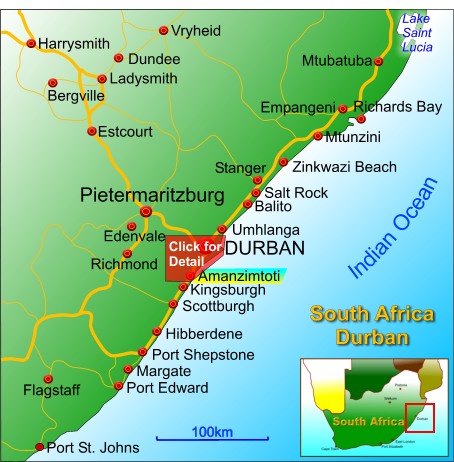
So here we were at the end of January getting ready to set sail again. Even “old salts” like Margie and me get a bit rusty after such a long time….Well, at least that’s my excuse for all the following foibles. (Say “following foibles” 3 times fast! Bet you can’t do it!)
Regardless of the distance, leaving one port for another always entails prep work both topsides and down below decks. Margie is usually in charge down below and I am in charge up on the topside and below the waterline. Busy on deck and appreciating the fast approaching night, I re-led the genoa and staysail sheets, moved the running backstays into position, brought the halyards back to the mast and stowed away the loose items. Previously, I had changed the oil, checked the steering, autopilot and engine gears and dived down with my scuba gear to clean the bottom while also changing the zincs on the shaft and propeller. I thought my job was done.
Below decks Margie quickly had the boat ready for sea. When I asked why she did not remove the books from the shelves she said that it “was just a short trip” down the coast. And, after all, hadn’t I told her that the weather charts and “grib files” that I consulted looked fine?
“Grib Files” are graphic weather files we download that show wind direction and strength. I had downloaded a file early that morning (or was it the night before?) and the wind velocity was predicted to be about 20 knots and on our port aft quarter. Thus, the wind and waves would be pushing us along in the right direction. Looks good right?
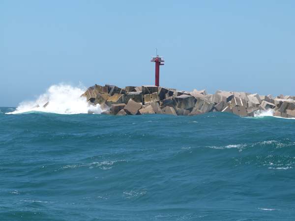
We left the dock well after sunset and about 45 minutes before dark. We called Port Control on VHF, Channel 9, to announce our intention to enter the main shipping channel that passes through a long breakwater to seaward. However, instead of being told to proceed, we were instructed to wait until an incoming cargo ship entered the port. We drove in circles for 45 minutes (Yes, it became very dark) until the ship had passed. We shoulda called BEFORE we left the dock!
Once given the “go ahead,” we proceeded down the marina inlet to the main shipping channel. Along the way, Margie noted that…“The tide looks really low.” She could see that the channel sand banks and rock ledges we were running parallel with were “high and dry” above the low water mark!
Opps! We had forgotten to check the tide which was at a monthly low. We had also forgotten that when we entered the marina, a fellow cruiser advised us to do so only at half-tide or higher. Now it was dark with rocks on both sides and the depth meter was going down, down, down!
We ended up with almost no water under the keel. At one point, the depth meter actually read 0.0 but somehow we did not hit bottom and we clawed our way out into the main shipping channel. Yikes!!! I woulda preferred not to start out our trip that way! As you can imagine, I was getting the old “evil eye” from Margie!
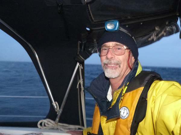
Once in the main shipping channel, we proceeded down between the long rock breakwaters on either side which lead out to sea. The wind had increased to 35 knots which was sending big waves coursing down the channel right into our bow. Peregrina was hobby-horsing up and down in the very steep rollers. So much for the 20 knot wind prediction! I guess I shoulda looked at the “grib files” once more before we left our protected marina which had almost no wind blowing!
Next, I looked towards the boat’s bow and the blue canvas cover over the dinghy, which sits on the foredeck when we are at sea, was flapping all over the place indicating that the tie down straps were not tight. I put on my PFD (personal flotation device) with my safety harness and prepared to go on deck. Whoops!!! I had forgotten to put on the “jacklines” which are long webbed straps that go from the bow of the boat to the stern. These are the safety lines that I clip my harness tether into to keep me from falling off the boat. Nevertheless, off I must go, holding on tight and clipping to the port shroud wires after I had made my way to the dinghy. This time it was more than the old “evil eye” I got from Margie. I got a full-blown “piece of her mind!”
However, I had no choice…the dingy cover was inflating with the wind because the tie-down straps weren’t tight. The tie-down straps weren’t tight because I had deflated the dinghy before we left for Christmas so that it would not overinflate in the heat while we were gone. I had forgotten to re-inflate it. While I was figuring all this out, the bow was rising and falling into the waves and water was bursting all around and over me. Working for about ten minutes I was able to tighten up the straps and I returned to the cockpit totally wet and a bit tired.
We then noticed that the starboard running light, used to alert other vessels of our course, was not working. I had forgotten to check that also. Good God, what more could go wrong?
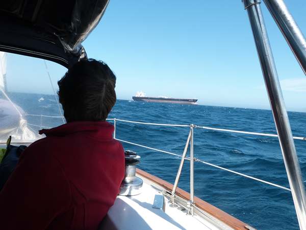
Exiting the channel, we spent the next hour dodging around the many huge cargo ships (up to a thousand feet long) that were peacefully riding at anchor in the same wind and sea that was throwing Peregrina around like a cork.
The wind turned out to be almost on our stern - known as a following wind - instead of on our port quarter which would have been a much more pleasant angle known as a “reach”. The following wind made Peregrina roll terribly and caused the one sail we had up - a reefed jib – to collapse repeatedly. On top of that, we had entered the mighty southbound Agulhas Current which follows the continental shelf down to the Roaring 40’s or 40 degrees South Latitude – an area known for its high winds and rough seas. This current is almost 100 miles wide and travels up to 5 knots in places so we were flying - 7-8 knots with just a sliver of the jib out - straight into huge troughs of waves.
Still above deck, I had forgotten to re-rig the boom preventer line which keeps the boom centered and not swinging wildly when the mainsail is not being used. In these windy conditions, it was flying back and forth and crashing down on the canvas top over the cockpit and threatening to break the aluminum support bars. Ok, back onto the deck – again with no “jacklines” for safety. Again, Margie is NOT amused!
But, down below, Margie’s area was not doing so well either! Dozens of books had cascaded off the shelves and were scattered around the floor. Unsecured items in the galley had launched themselves into trajectories that ended up both in the aft stateroom as well as the forward dining area. Soap bars abandoned their dishes and broke into pieces on the floor. Margie was slipping and sliding every which way and NOT a happy camper!
Once she got that mess cleaned up, Margie went “off watch” around 10pm but was back up in about a half hour saying she could not sleep. I asked her why and she just said “Why don’t you go down and give it a go?” Well, I did and found out why she had trouble sleeping. The seas were lifting the stern of the boat (where we sleep) and dropping it off sharply as the top of the wave passed by with a huge crash that reverberated right under our bed.
In addition to the vertical drop, there was also a twisting motion as our bodies levitated into the air and came down in a completely different place on the mattress. For a moment, it seemed like we were defying gravity and then we’d be tossed and turned from one side of Peregrina to another! I don’t think either one of us got more than an hour of sleep that night!
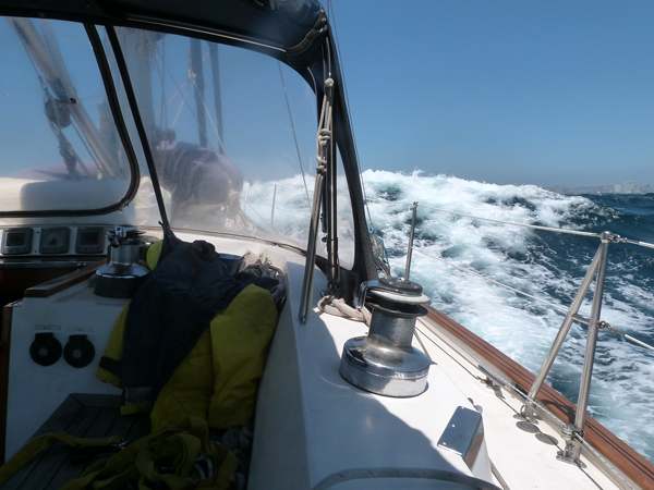
About 3am in the morning, Margie was fiddling around with the Raymarine chart plotter which we use for navigation and to transmit our position to other vessels in the vicinity as well as to identify other vessels that might pose a problem to us if our courses were to intersect. It’s a vital part of our electronic navigation system and, without it, we’re back in the Dark Ages of seamanship. All of a sudden, Margie, who is down below, shrieks! She comes up on deck saying that she’s not sure what button she hit but everything went black! Ohhhh…not good! Margie shoulda NEVER been “fiddling with the machinery” as she described it!
I go down to try to re-start the chart plotter and after repeated attempts a chart from Miami, Florida comes on the screen. Now this is really hard to understand since the chart plotter reads maps based on a little chip that is inserted into the chart chip slot. I have the South Africa chip inserted so where in God’s name did a chart of Miami come from? At this point, I’m thinking…”Maybe this is an omen telling me I shoulda never left home”!
So, I’ve got no electronics. What can I do? I get out our little Acer notebook computer, with a remote cord GPS antenna, which serves as our back up navigation. Gee, what a surprise! I forgot to check the battery status prior to leaving and it is dead. I bought it in Malaysia so I have to look for the adapter to connect the Malaysian plug to our US style receptors. Now where the heck is that plug?
After a while, I get the computer going and, luckily, find we have not closed on the shallow water and reefs to starboard too, too much! I establish a new course and return to work on the main Raymarine Chart Plotter which has AIS.
Now, AIS stands for Automatic Identification System and it is a transponder and a receiver. It transmits signals about Peregrina’s course to vessels approaching and receives information about vessels that may be headed towards us. And there are some very big vessels going up and down the west coast of Africa…some maybe right on our nose!
After about a half hour, I get our Raymarine charting back up on the screen with the correct map for South Africa displayed. But, there is no AIS and, every once in a while, the screen flutters and a warning box appears that says the GPS navigational fix is lost. Needless to say, this is disheartening!
So, for the next three hours until daylight, Margie and I have to depend on our radar system to dodge several large commercial vessels coming up the coast. Radar is much less sophisticated than a GPS based AIS system and while I can make out objects that may or may not be vessels, based on what I can see on my radar screen, I don’t know if they see me!
Later, at the dock, I called Raymarine in the UK who informed me that Margie, when she was trying to re-set the time, had somehow pressed the button for a Total System Reset! Thus, the programming information for the addition of the external AIS and the external GPS antenna had been lost. This was an easy fix if you know what to look for and I will next time. But, the learning is not to make programming changes to sophisticated electronics at 2pm at night, with heavy seas and dangerous shores to starboard. Margie coulda waited until we were safely in the marina to “fiddle” with the machinery!
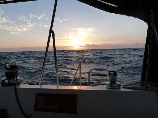
About 5am the sun came up which always is a reassuring sign and the warmth provided both physical and emotional support.
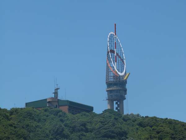
As we approached Durban harbor, we got in contact with the Port Control Tower located on the mountain top. They gave us permission to enter through the breakwater after dodging some incoming vessels. They have very exotic headquarters! Durban is the 9th largest harbor in the world with 15.5 kilometers of quays handing more than 18 million tons of cargo and 3000 ships annually.
So, our long night’s journey into day was over…PHEW!!!!!
Were we in danger ever…probably not. Were we dumb and did we forget to prepare the boat properly for sea as we had done a thousand times before. The answer is definitely YES.
We shoulda had a written “check list” of things to do before putting out to sea. We coulda kept it in the blue plastic binder labeled “Peregrina Procedures”. Oh yeah, I forgot…We DO have one there!
We woulda been smart to consult it before leaving. Next time, NO shoulda, coulda, woulda’s!!!
--