Peros Banhos to Ile Takamaka in the Salomon Islands
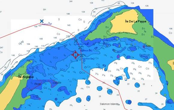
Position 05:19.985 S 072:15.869 E Date 1410 (UTC+5) Sunday 24 April 2016 Distance run 32.9nm over the ground We delayed our departure until after 0900 to get good enough light to see any hazards but not too late so that we would not have good light for negotiating the somewhat tricky looking pass into the Salomon Islands Atoll. The first part of this master plan was OK but the second was somewhat upset by the steady bank of squalls and rain that appeared mid-morning. Fortunately, a break in the weather, some waypoints taken from Google Earth KAP file overlays and some reference to the up to date electronic charts, C-Map and Navionics, meant that we found our way safely into the Atoll. The least depth encountered over the bar was 4.0m under the keel (a total of 6m). We entered at one hour before high water when there was a rise of about 1m.
Our chosen path over the bar into the Salomon Islands Atoll The poor light meant that we were unwilling to try and find our way into the Ile Boddam anchorage which looks to be somewhat tricky. The only alternative that is BIOT designated was on the eastern side of the lagoon off Ile Takamaka (also spelt Yakamaka on the current C-Map). This was a lee shore but with generally light winds it would do overnight and there was an open access to deeper water if necessary. We initially dropped the anchor in 20m on a flat bottom and we assume sand to allow a bank of rain to pass through. When the light improved we moved onto large bank of sand where we were able to anchor in 4m, 2m under the keel. Diving to check the anchor was no problem and it was well dug in in firm sand.
The Takamaka anchorage area is to the south east of the line joining the two black crosses |