Lovina to Kumai Day 2 - What did we avoid today
Position 04:30.15 S 112.29.45 E Date 1200 (UTC+8) Wednesday 11 November 2015 Distance run In 24hrs 153nm over the ground, 152nm though the water Trip total 278m over the ground, 280m through the water This was definitely a day of no wind and we motored the whole 24 hours in a calm sea, occasionally getting some benefit from setting sails to use our diesel originated wind. The major interest of the day was collecting a variety of new and different hazards of the course. There were of course fishing boats in all shapes and sizes, non with AIS and with varying radar images, and a significant amount of commercial shipping. The Java Sea has some major shipping routes with Singapore as the focus at the western end.
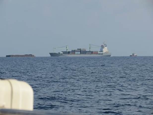
Something new - We snuck in ahead of this crossing traffic To explain the photograph. The tug on the right is towing the barge on the left joined together by a 400 meter tow line. The ship travelling right to left is between us and the tug and tow. The ship had AIS but the tug did not. It did give a good radar picture. This was not a one off and we saw a further two tug and tows in the 24 hours all travelling towards Java. A wildlife visit livened up the late afternoon when a swift not only flew round the boat but through a number of times. The agility of these small birds in confined spaces is absolutely amazing. It seemed unfazed by my presence and having checked things out and had a meaningful chirrup it went on its happy way. I was rather hoping that we might have picked up a hitchhiker. The first thing that the Mate noticed when she came up at 0730 was a row of small fishing floats. These extended a good 500m side to side of our path with the ends being marked by a float and flag. They were impossible to see at much more than 300 meters. We certainly would not wish to have trawled that lot. |