Noumea to Kupang Day 12 - Sailing down a marine highway
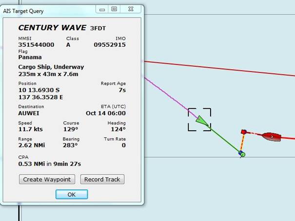
Position 10:10.39 S 136:54.66 E Date 1200 (UTC+10) Tuesday 13 October 2015 Distance run in 24hrs 157nm over the ground, 145nm through the water Trip total 1967nm over the ground, 1907nm through the water To go to Kupang Indonesia 838nm The wind she keeps a blowin’ and the current she keeps a flowin’, all of it is favourable – and we are not complaining. The current forecast says that this will all come to an end when we are 200nm from our destination as we appear to be moving forward in a trade wind bubble so we should have another four days of this. Our course seems to be very popular with the merchant shipping lot. I have referred to AIS (Automatic Identification System) and I thought that for those non sailors reading this it might be useful to show one of this morning’s near misses. AIS has to be fitted to all craft over 150 in length, usually of a type known as Class A. Effectively this means all commercial vessels that you are likely to encounter on the high seas, with the exception of far eastern fishing vessels, China, Korea etc., who are a law into themselves. An increasing number of cruising yachts, ourselves included, have AIS fitted but of Class B which is less expensive but perfectly adequate for our use. AIS basically transmits data about course and speed, the name and radio call signs and the size and nature of the vessel. In addition Class A transmits information about the current destination and other information not displayed by our system.
Incoming hostile? Century Wave on its way to Weipa in Northern Queensland, Australia We run two AIS systems on board, both fed from a common AIS transmitter/receiver. One is part of our Raymarine chart plotter and the other is part of a PC based chart plotter system called OpenCPN. Both effectively plot the position of the AIS target on the chart screen and make a calculation using our own speed and course to give a projected CPA (closest point of approach) and TCPA, the time to the CPA. The screen shot above is taken from OpenCPN and shows an approaching vessel, the Century Wave at a range of 2.62nm that will get to within 0.53nm of us in 9min 27s. OpenCPN also gives a useful graphical overlay that displays both our projected courses. Our current version of the Raymarine software provides this information but in not so easy to use display. There is a new release of the software that is supposed to remedy shortcomings. We will install this when we have a good enough internet connection to download he 850Mb file.
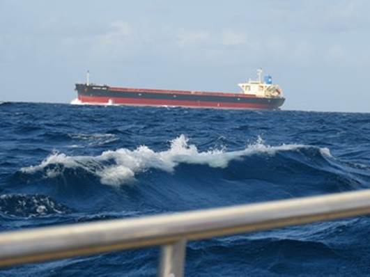
And that is close enough at about a half a mile We have an alarm set that sounds of an AIS target gets to within 3 minutes of a 2nm safety zone, just in case all else fails. There are many cruising yachts out there without AIS, their choice but in our opinion a stress relieving life saver if there ever was one. We would not sail without it. It is of interest to note that Singapore insists that all yachts travelling in its territorial waters has an AIS transmitter, no doubt the primary reason for this is plotting craft in those very busy waters. |